中国沙漠 ›› 2021, Vol. 41 ›› Issue (1): 183-194.DOI: 10.7522/j.issn.1000-694X.2020.00089
王旭洋( ), 李玉霖(), 连杰, 段育龙, 王立龙
收稿日期:2020-06-10
修回日期:2020-09-03
出版日期:2021-01-29
发布日期:2021-01-29
通讯作者:
李玉霖
作者简介:李玉霖(E-mail: liyl@lzb.ac.cn基金资助:
Xuyang Wang(), Yulin Li(), Jie Lian, Yulong Duan, Lilong Wang
Received:2020-06-10
Revised:2020-09-03
Online:2021-01-29
Published:2021-01-29
Contact:
Yulin Li
摘要:
中国北方四大沙地(毛乌素沙地、浑善达克沙地、科尔沁沙地、呼伦贝尔沙地)是半干旱地区荒漠化发展的典型地区和荒漠化防治的重点区域。分析四大沙地植被覆盖度的时空演变规律及其对气候要素的响应机制,对保护北方生态脆弱区的生物多样性与生态安全具有重要意义。基于1998—2018年SPOT-VEGETATION的植被覆盖度指数(NDVI)数据,结合相应气候资料数据分析发现:四大沙地NDVI年际波动较大,毛乌素沙地和科尔沁沙地植被覆盖度总体趋于好转态势,分别有75.22%和42.06%的面积植被得到改善,而浑善达克沙地和呼伦贝尔沙地植被覆盖度呈非显著下降趋势,其发生植被退化的面积比例分别为60.04%和51.4%。结合极端气候指数分析表明,呼伦贝尔沙地NDVI与持续湿润指数(CWD)的正相关系数最高(r=0.429),而浑善达克沙地NDVI与持续干旱指数(CDD)的负相关系数最大(r=-0.264),表明呼伦贝尔沙地和浑善达克沙地植被分别对持续湿润和持续干旱事件响应最为敏感。基于不同沙地的植被变化驱动分区,建议在毛乌素沙地非气候驱动区域继续实施禁牧封育和飞播造林技术,而在气候驱动区域主要采取封育措施;在浑善达克沙地实施生态移民和“以地养地”模式;对科尔沁沙地的疏林草原应采取严格的封育措施;在呼伦贝尔沙地要坚持生物措施与工程措施相结合,形成“外围封禁、边缘治理、内部发展”的生态发展格局。
中图分类号:
王旭洋, 李玉霖, 连杰, 段育龙, 王立龙. 半干旱典型风沙区植被覆盖度演变与气候变化的关系及其对生态建设的意义[J]. 中国沙漠, 2021, 41(1): 183-194.
Xuyang Wang, Yulin Li, Jie Lian, Yulong Duan, Lilong Wang. Relationship between vegetation coverage and climate change in semi-arid sandy land and the significance to ecological construction[J]. Journal of Desert Research, 2021, 41(1): 183-194.
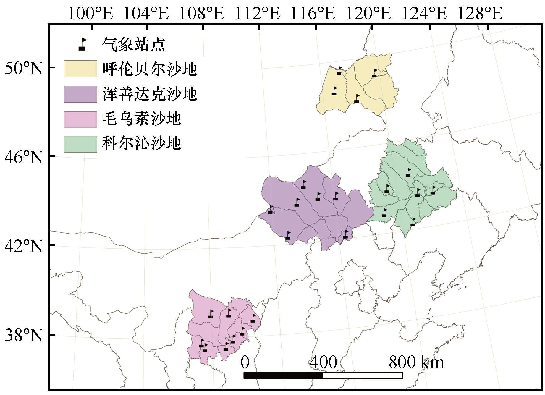
图1 研究区位置
Fig.1 Location of the study area
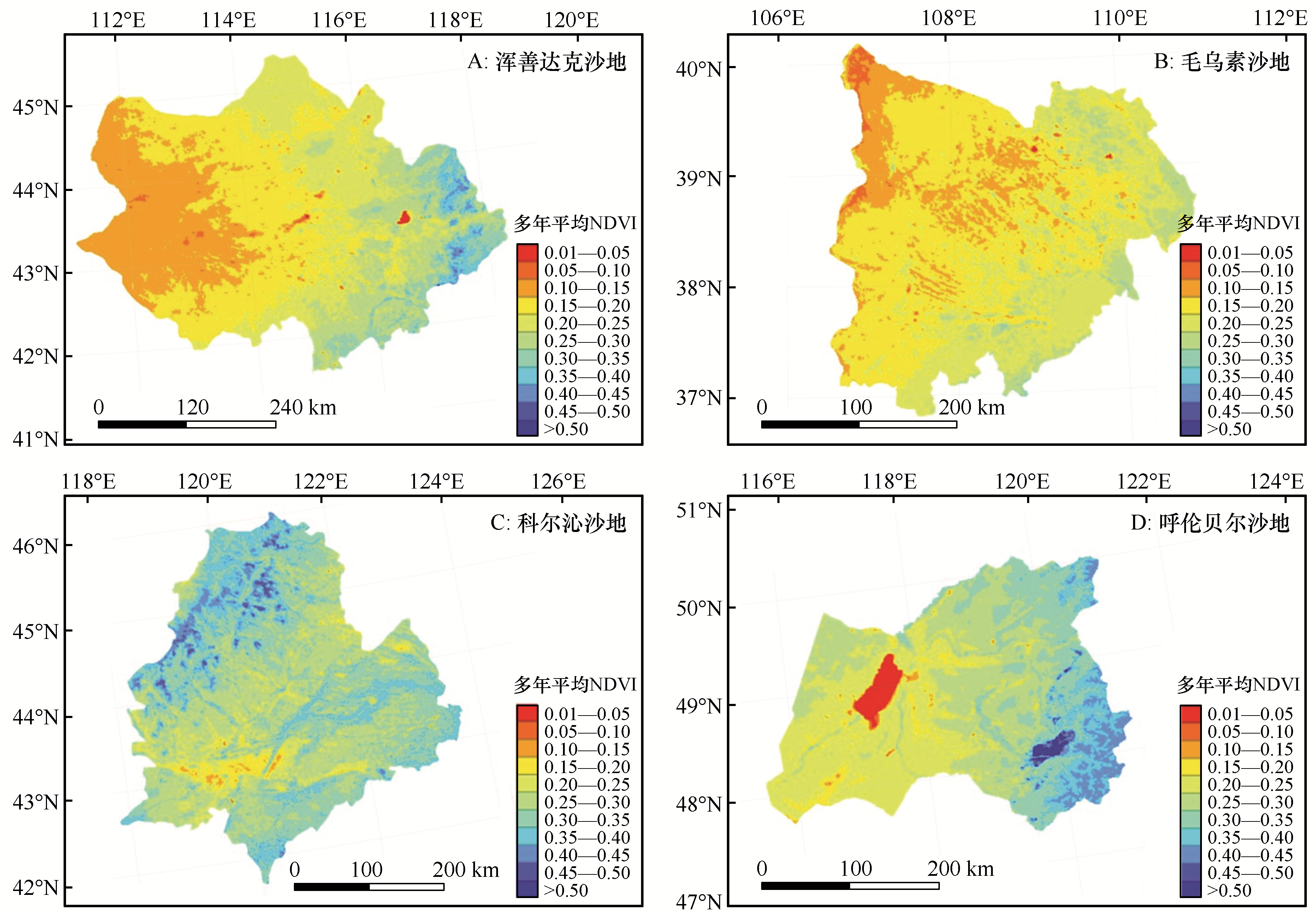
图2 中国半干旱典型风沙区1998—2018年平均NDVI空间分布特征
Fig.2 Spatial distribution of the multi-year mean normalized-difference vegetation index (NDVI) in semi-arid sandy land of China from 1998 to 2018
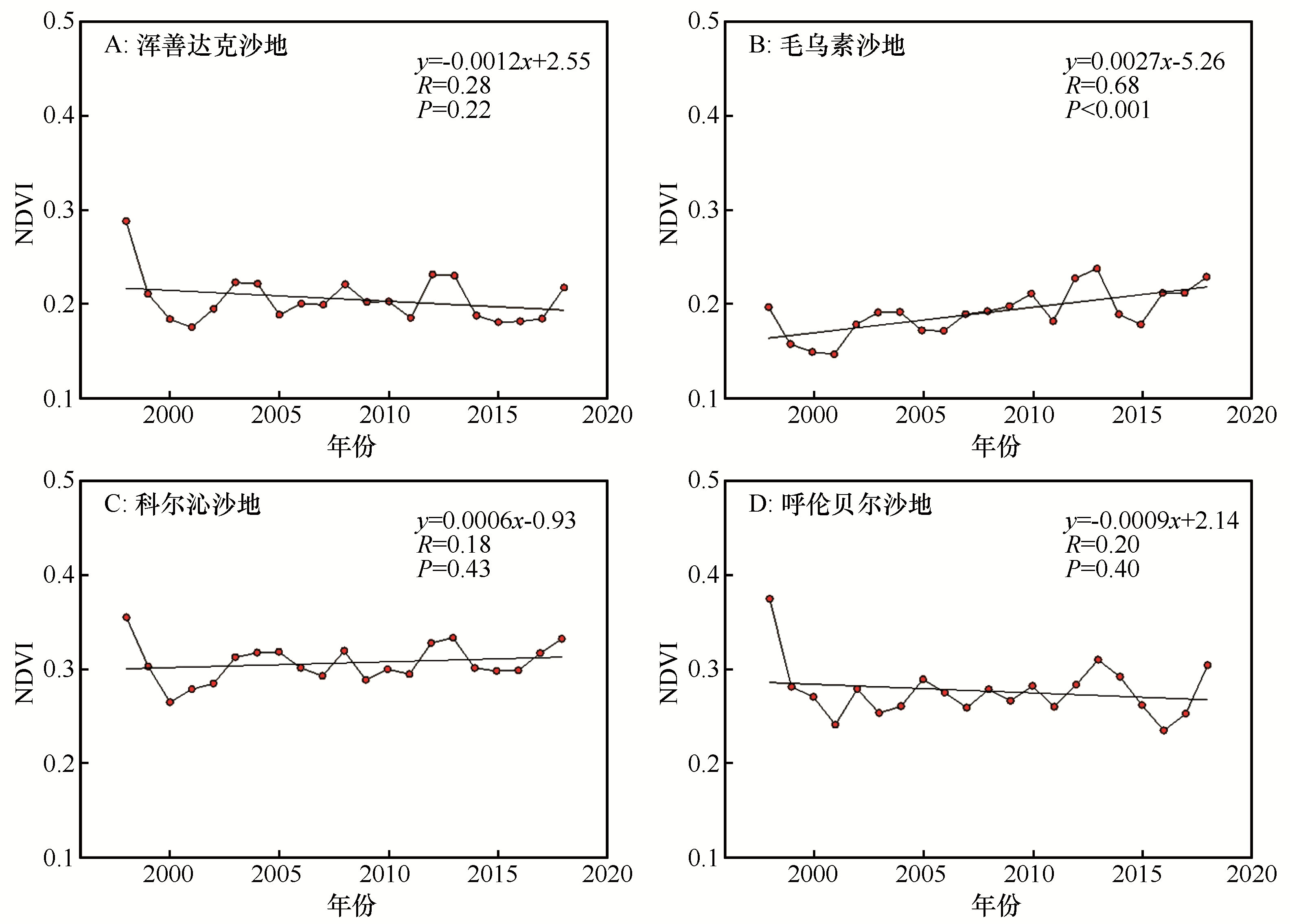
图3 中国半干旱典型风沙区1998—2018年NDVI年际变化
Fig.3 The inter-annual variations of the normalized-difference vegetation index (NDVI) in semi-arid sandy land of China from 1998 to 2018

图4 中国半干旱典型风沙区1998—2018年NDVI空间格局变化
Fig.4 Spatial pattern change of the normalized-difference vegetation index (NDVI) in semi-arid sandy land of China from 1998 to 2018
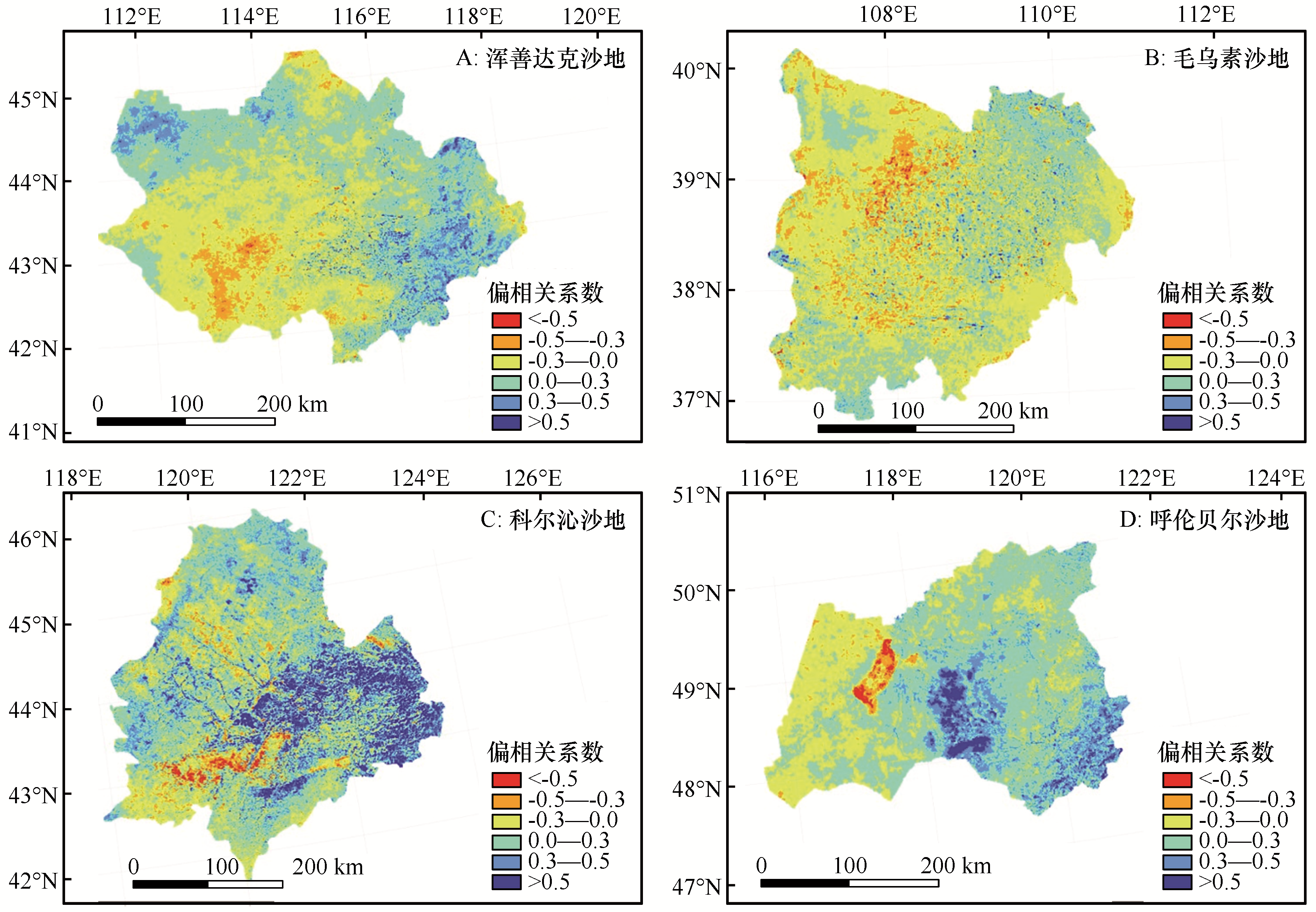
图5 中国半干旱典型风沙区1998—2018年NDVI与气温的偏相关系数空间分布
Fig.5 Spatial distribution of partial correlations between the multi-year mean normalized-difference vegetation index (NDVI) and the mean annual temperature in semi-arid sandy land of China from 1998 to 2018
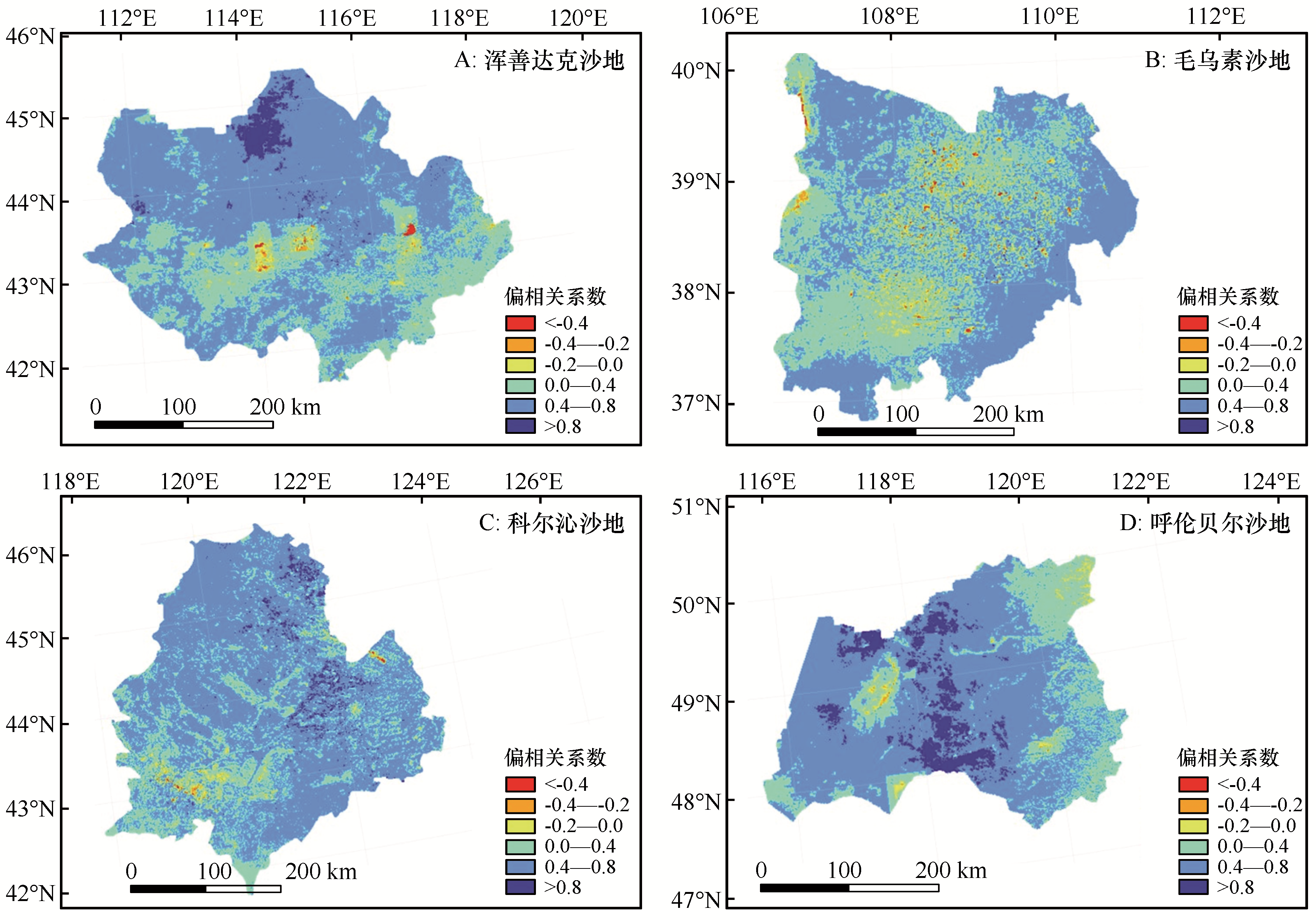
图6 中国半干旱典型风沙区1998—2018年NDVI与降水的偏相关系数空间分布
Fig.6 Spatial distribution of partial correlations between the multi-year mean normalized-difference vegetation index (NDVI) and the mean total annual precipitation in semi-arid sandy land of China from 1998 to 2018

图7 中国半干旱典型风沙区1998—2018年NDVI与气温-降水的复相关系数空间分布
Fig.7 Spatial distribution of the multiple-correlation coefficient between the multi-year mean normalized-difference vegetation index (NDVI) and the two climate drivers (temperature and precipitation) in semi-arid sandy land of China from 1998 to 2018
| NDVI变化驱动因子 | C1 | C2 | C3 | |
|---|---|---|---|---|
| 气候因子 | [T+P]+ | P < 0.01 | P < 0.01 | P < 0.05 |
| T | P < 0.01 | P ≥ 0.01 | P < 0.05 | |
| P | P ≥ 0.01 | P < 0.01 | P < 0.05 | |
| [T+P] | P ≥ 0.01 | P ≥ 0.01 | P < 0.05 | |
| 非气候因子 | NC | P ≥ 0.01 | P ≥ 0.01 | P ≥ 0.05 |
表1 NDVI变化驱动力分区准则
Table 1 The criteria used for classification of the driving factors for dynamic changes of the normalized-difference vegetation index (NDVI).
| NDVI变化驱动因子 | C1 | C2 | C3 | |
|---|---|---|---|---|
| 气候因子 | [T+P]+ | P < 0.01 | P < 0.01 | P < 0.05 |
| T | P < 0.01 | P ≥ 0.01 | P < 0.05 | |
| P | P ≥ 0.01 | P < 0.01 | P < 0.05 | |
| [T+P] | P ≥ 0.01 | P ≥ 0.01 | P < 0.05 | |
| 非气候因子 | NC | P ≥ 0.01 | P ≥ 0.01 | P ≥ 0.05 |

图8 中国半干旱典型风沙区1998—2018年NDVI变化驱动力分区
Fig.8 Spatial distribution of the effects of the driving factors on changes in the multi-year normalized-difference vegetation index (NDVI) in semi-arid sandy land of China from 1998 to 2018
| 指数 | 呼伦贝尔沙地 | 浑善达克沙地 | 科尔沁沙地 | 毛乌素沙地 |
|---|---|---|---|---|
| CWD | 0.429** | 0.362** | 0.068 | 0.138 |
| CDD | -0.225 | -0.264** | -0.004 | -0.189* |
表2 NDVI与极端降水指数的相关关系
Table 2 Correlation between normalized-difference vegetation index (NDVI) and extreme precipitation index
| 指数 | 呼伦贝尔沙地 | 浑善达克沙地 | 科尔沁沙地 | 毛乌素沙地 |
|---|---|---|---|---|
| CWD | 0.429** | 0.362** | 0.068 | 0.138 |
| CDD | -0.225 | -0.264** | -0.004 | -0.189* |
| 1 | 李广清.人类面对荒漠化的问题应采取的对策[J].中国环境管理干部学院学报,2004(3):65-67. |
| 2 | 王涛,吴薇,薛娴,等.近50年来中国北方沙漠化土地的时空变化[J].地理学报,2004(2):203-212. |
| 3 | 尚可政,董光荣,王式功,等.我国北方沙区气候变化对全球变暖的响应[J].中国沙漠,2001,21(4):72-77. |
| 4 | 朱芳莹,鹿化煜,弋双文,等.基于NDVI指数的浑善达克沙地植被时空变化规律分析[J].中国水土保持,2017(3):31-34,69. |
| 5 | 赵哈林,赵学勇,张铜会.我国北方农牧交错带沙漠化的成因、过程和防治对策[J].中国沙漠,2000,20():23-29. |
| 6 | 薛娴,王涛,吴薇,等.中国北方农牧交错区沙漠化发展过程及其成因分析[J].中国沙漠,2005,25(3):320-328. |
| 7 | 蒋卫国,陈云浩,李京,等.中国北方农牧交错带生态环境的空间格局演变[J].自然资源学报,2005(6):77-84. |
| 8 | Wang X Y,Li Y Q,Gong X W,et al.Storage,pattern and driving factors of soil organic carbon in an ecologically fragile zone of northern China[J].Geoderma,2019,343:155-165. |
| 9 | Sun W,Song X,Mu X,et al.Spatiotemporal vegetation cover variations associated with climate change and ecological restoration in the loess plateau[J].Agricultural and Forest Meteorology,2015,209(1):87-99. |
| 10 | Liu X,Zhou W,Bai Z.Vegetation coverage change and stability in large open-pit coal mine dumps in China during 1990-2015[J].Ecological Engineering,2016,95:447-451. |
| 11 | Fung T,Siu W.Environmental quality and its changes,an analysis using NDVI[J].International Journal of Remote Sensing,2000,21:1011-1024. |
| 12 | Pettorelli N,Vik J O,Mysterud A,et al.Using the satellite-derived NDVI to assess ecological responses to environmental change[J].Trends in Ecology & Evolution,2005,20:503-510. |
| 13 | Clerici N,Weissteiner C J,Gerard F.Exploring the use of MODIS NDVI-based phenology indicators for classifying forest general habitat categories[J].Remote Sensing,2012,4(6):1781-1803. |
| 14 | Feng L,Guo S,Zhu L,et al.Urban vegetation phenology analysis using high spatio-temporal NDVI time series[J].Urban Forestry & Urban Greening,2017,25:43-57. |
| 15 | Wardlow B D,Egbert S L.Large-area crop mapping using time-series MODIS 250 m NDVI data:an assessment for the U.S.Central Great Plains[J].Remote Sensing of Environment,2008,112:1096-1116. |
| 16 | Magney T S,Eitel J U H,Huggins D R,et al.Proximal NDVI derived phenology improves in-season predictions of wheat quantity and quality[J].Agricultural & Forest Meteorology,2016,217:46-60. |
| 17 | Pei H,Zhang S Y,Ao Y Q.Research on climate and climatic changes in Hunshandake Sandy Land[J].Land Meteorological Science and Technology,2005,33(1):63-67. |
| 18 | 张广才,于卫平,刘伟泽,等.毛乌素沙地不同治理措施植被恢复效果分析[J].林业科学研究,2004(B12):1-9. |
| 19 | Piao S L,Mohammat A,Fang J Y,et al.NDVI-based increase in growth of temperate grasslands and its responses to climate changes in China[J].Global Environmental Change,2006,16:340-348. |
| 20 | Schucknecht A,Erasmi S,Niemeyer I,et al.Assessing vegetation variability and trends in north-eastern Brazil using AVHRR and MODIS NDVI time series[J].European Journal of Remote Sensing,2013,46(1):40-59. |
| 21 | An Y,Gao W,Gao Z,et al.Assessment of desertification in the agro-pastoral transitional zone in Northern China (1982-2006) using GIMMS NDVI data[J].Remote Sensing and Modeling of Ecosystems for Sustainability,2015,8869:886913. |
| 22 | Miao L J,Ye P L,He B,et al.Future climate impact on the desertification in the dry land Asia using AVHRR GIMMS NDVI3g data[J].Remote Sensing,2015,7:3863-3877. |
| 23 | Gezahagn N S.Spatial assessment of NDVI as an Indicator of Desertification in Ethiopia Using Remote Sensing and GIS[D].Master degree thesis,30/credits in Master in Geographical Information Science Department of Physical Geography and Ecosystem Science, Lund University,2016. |
| 24 | Fathizad H,Ardakani M A H,Mehrjardi R T,et al.Evaluating desertification using remote sensing technique and object-oriented classification algorithm in the Iranian central desert[J].Journal of African Earth Sciences,2018,145(SEP):115-130. |
| 25 | 王涛.中国沙漠与沙漠化[M].石家庄:河北科学技术出版社,2003:525-574. |
| 26 | 闫峰,吴波.近40 a毛乌素沙地荒漠化过程研究[J].干旱区地理,2013,36(6):987-996. |
| 27 | 张宝珠,金维林,葛士林,等.呼伦贝尔沙地治理布局及治理模式[J].中国沙漠,2013,33(5):1310-1313. |
| 28 | 李春兰,朝鲁门,包玉海,等.21世纪初期气候波动下浑善达克沙地荒漠化动态变化分析[J].干旱区地理,2015,38(3):556. |
| 29 | 王旭洋,李玉强,罗永清,等.科尔沁沙地不同生境植被凋落物年际及年内动态[J].应用生态学报,2018,29(5):124-132. |
| 30 | 于娜,赵媛媛,丁国栋,等.基于生态足迹的中国四大沙地地区可持续评价[J].干旱区地理,2018,41(6):170-180. |
| 31 | Purevdorj T,Tateishi R,Ishiyama T,et al.Relationships between percent vegetation cover and vegetation indices[J].International Journal of Remote Sensing,1998,19:3519-3535. |
| 32 | Stow D,Petersen A,Hope A,et al.Greenness trends of Arctic tundra vegetation in the 1990s:comparison of two NDVI data sets from NOAA AVHRR systems[J].International Journal of Remote Sensing,2007,28:4807-4822. |
| 33 | 方精云,朴世龙,贺金生,等.近20年来中国植被活动在增强[J].中国科学(C辑),2003,33(6):554-565. |
| 34 | 李月臣,宫鹏,刘春霞,等.北方13省1982-1999年植被变化及其与气候因子的关系[J].资源科学,2006,28(2):109-117. |
| 35 | 高志强,刘纪远,曹明奎,等.土地利用和气候变化对区域净初级生产力的影响[J].地理学报,2004,59(4):581-591. |
| 36 | 刘军会,高吉喜.气候和土地利用变化对北方农牧交错带植被NPP变化的影响[J].资源科学,2009,31(3):493-500. |
| 37 | Mohamed M A A,Babiker I S,Chen Z M,et al.The role of climate variability in the inter-annual variation of terrestrial net primary production (NPP)[J].Science of the Total Environment,2004,332(1/3):123-137. |
| 38 | 陈云浩,李晓兵,史培军.1983-1992年中国陆地NDVI变化的气候因子驱动分析[J].植物生态学报,2001,25(6):716-720. |
| 39 | Nemani R R,Keeling C D,Hashimot H,et al.Climate-driven increased in global terrestrial net primary production from 1982 to 1999[J].Science,2003,300:1560-1563. |
| 40 | Zhao X,Tan K,Zhao S,et al.Changing climate affects vegetation growth in the arid region of the northwest China[J].Journal of Arid Environments,2011,75:946-952. |
| 41 | 王涛,杨梅焕.榆林地区植被指数动态变化及其对气候和人类活动的响应[J].干旱区研究,2017,34(5):1133-1140. |
| 42 | 张戈丽,徐兴良,周才平,等.近30年来呼伦贝尔地区草地植被变化对气候变化的响应[J].地理学报,2011,66(1):47-58. |
| 43 | 邵艳莹.中国四大沙地植被动态变化及其对气候变化的响应[D].北京:北京林业大学,2018. |
| 44 | 杜加强,贾尔恒·阿哈提,赵晨曦,等.1982-2012年新疆NDVI的动态变化及其对气候变化和人类活动的响应[J].应用生态学报,2015,26(12):3567-3578. |
| 45 | De Jong R,Verbesselt J,Schaepman M E,et al.Trend changes in global greening and browning:contribution of short-term trends to longer-term change[J].Global Chang Biology,2012,18:642-655. |
| 46 | Wessels K J,van den Bergh F,Scholes R J.Limits to detectability of land degradation by trend analysis of vegetation index data[J].Remote Sensing of Environment,2012,125:10-22. |
| 47 | Yang X,Ding Z,Fan X,et al.Processes and mechanisms of desertification in northern China during the last 30 years,with a special reference to the Hunshandake Sandy Land,eastern Inner Mongolia[J].Catena,2007,71(1):2-12. |
| 48 | 李震,阎福礼,范湘涛.中国西北地区NDVI变化及其温度和降水的关系[J].遥感学报,2005,9(3):308-313. |
| 49 | Li X R,Zhang Z S,Huang L,et al.Review of the ecohydrological processes and feedback mechanisms controlling sand-binding vegetation systems in sandy desert regions of China[J].Chinese Science Bulletin,2013,58(13):1483-1496. |
| 50 | Feng X,Fu B,Piao S,et al.Revegetation in China's Loess Plateau is approaching sustainable water resource limits[J].Nature Climate Change,2016,6(11):1019-1022. |
| 51 | Menz M H M,Dixon K W,Hobbs R J.Hurdles and opportunities for landscape-scale restoration[J].Science,2013,339(6119):526-527. |
| 52 | 安云.毛乌素沙地4种典型植被恢复模式生态效益分析[D].北京:北京林业大学,2013. |
| 53 | 边振,张克斌,李瑞,等.封育措施对宁夏盐池半干旱沙地草场植被恢复的影响研究[J].水土保持研究,2008,15(5):68-70. |
| 54 | 李维向,闫伟,刘朝霞,等.毛乌素沙区腹地提高飞播成效的技术措施研究[J].中国沙漠,2009,29(1):114-117. |
| 55 | 包雪原.浑善达克沙地植被恢复与重建途径研究[J].干旱区资源与环境,2004,18(8):128-132. |
| 56 | 彭羽.浑善达克沙地退化生态系统生态恢复的自然保护区途径[D].北京:中国科学院研究生院(植物研究所),2005. |
| 57 | 唐毅,蒋德明,陈雪峰,等.疏林草原榆树天然更新研究进展[J].中国沙漠,2011,31(5):1226-1230. |
| 58 | 李钢铁,姚云峰,张德英,等.科尔沁沙地疏林草原植被恢复技术体系[J].内蒙古农业大学学报(自然科学版),2005,26(3):1-6. |
| 59 | 郑翠玲,曹子龙,王贤,等.围栏封育在呼伦贝尔沙化草地植被恢复中的作用[J].中国水土保持科学,2005,3(3):78-81. |
| 60 | 吴锈钢,宋小东,王恩利,等.沙地樟子松人工林结构调整及更新改造技术措施[J].防护林科技,2002,53(4):82-83. |
| 61 | 刘康,王效科,杨帆,等.红花尔基地区沙地樟子松群落及其与环境关系研究[J].生态学杂志,2005,24(8):858-862. |
| 62 | 吕世海,卢欣石.呼伦贝尔草地风蚀沙化植被生物多样性研究[J].中国草地学报,2006,28(4):6-10. |
| 63 | 闫德仁,张宝珠.呼伦贝尔沙地研究综述[J].内蒙古林业科技,2008,34(3):34-39. |
| [1] | 陈银萍, 曹雯婕, 余沛东, 杨欢, 王旭洋, 李玉强. 土壤含水率对风沙流结构及风蚀量的影响[J]. 中国沙漠, 2021, 41(2): 173-180. |
| [2] | 李向洁, 李志文, 詹江振, 孙丽, 杜兰, 侯楚. 南昌厚田沙地沉积物的粒度特征及其影响因素[J]. 中国沙漠, 2021, 41(2): 92-99. |
| [3] | 田敏, 钱广强, 杨转玲, 罗万银, 逯军峰. 柴达木盆地东北部哈勒腾河流域风况特征及其对风沙地貌发育的影响[J]. 中国沙漠, 2021, 41(1): 1-9. |
| [4] | 朱宾宾, 孙双红, 李艳红, 张红蕾, 景璐, 王立军, 曹伟. 呼伦贝尔沙地紫外辐射和太阳总辐射特征[J]. 中国沙漠, 2021, 41(1): 111-118. |
| [5] | 曹永香, 毛东雷, 蔡富艳, 王雪梅, 开买尔古丽·阿不来提null, 苏松领. 新疆策勒绿洲化进程中典型下垫面的小气候空间差异[J]. 中国沙漠, 2020, 40(6): 180-189. |
| [6] | 孙一梅, 田青, 郭爱霞, 左小安, 吕朋, 张森溪. 水、氮施用量对科尔沁沙地植被特征和叶性状的影响[J]. 中国沙漠, 2020, 40(6): 223-232. |
| [7] | 常亚斌, 朱睿, 肖生春, 李雅培. 1980-2015年阿拉善盟沙地面积变化及其驱动因子[J]. 中国沙漠, 2020, 40(6): 82-90. |
| [8] | 赵媛媛, 武海岩, 丁国栋, 高广磊, 屠文竹. 浑善达克沙地土地沙漠化研究进展[J]. 中国沙漠, 2020, 40(5): 101-111. |
| [9] | 王姣月, 秦树高, 张宇清. 毛乌素沙地植被水分利用效率的时空格局[J]. 中国沙漠, 2020, 40(5): 120-129. |
| [10] | 周虹, 吴波, 高莹, 成龙, 贾晓红, 庞营军, 赵河聚. 毛乌素沙地臭柏(Sabina vulgaris)群落生物土壤结皮细菌群落组成及其影响因素[J]. 中国沙漠, 2020, 40(5): 130-141. |
| [11] | 詹瑾, 李玉霖, 韩丹, 杨红玲. 半干旱沙区3种优势固沙灌木生物量分配及其生态学意义[J]. 中国沙漠, 2020, 40(5): 149-157. |
| [12] | 刘任涛, 张安宁. 固沙灌丛林营造初期地面节肢动物群落结构特征[J]. 中国沙漠, 2020, 40(5): 190-199. |
| [13] | 许明静, 吕萍, 肖南, 杨军怀, 刘铮瑶, 冯淼彦, 梁准. 毛乌素沙地西北部植被覆盖对沙丘移动的影响[J]. 中国沙漠, 2020, 40(4): 71-80. |
| [14] | 苏郎嘎, 田桂泉, 红霞. 浑善达克沙地苔藓物种多样性[J]. 中国沙漠, 2020, 40(3): 51-59. |
| [15] | 邵梅, 罗万银, 车雪华. COSI-Corr技术在风沙地貌研究中的初步应用及精度检验[J]. 中国沙漠, 2020, 40(3): 151-158. |
| 阅读次数 | ||||||
|
全文 |
|
|||||
|
摘要 |
|
|||||
©2018中国沙漠 编辑部
地址: 兰州市天水中路8号 (730000)
电话:0931-8267545
Email:caiedit@lzb.ac.cn;desert@lzb.ac.cn

 甘公网安备 62010202000688号