中国沙漠 ›› 2022, Vol. 42 ›› Issue (4): 163-171.DOI: 10.7522/j.issn.1000-694X.2022.00011
• • 上一篇
吴盈盈1,3( ), 王振亭1,2
收稿日期:2021-10-09
修回日期:2022-01-19
出版日期:2022-07-20
发布日期:2022-08-29
作者简介:吴盈盈(1997—),女,陕西安康人,硕士研究生,主要从事风沙物理与治沙工程研究。E-mail: wuyingying20@mails.ucas.ac.cn
基金资助:
Yingying Wu1,3(), Zhenting Wang1,2
Received:2021-10-09
Revised:2022-01-19
Online:2022-07-20
Published:2022-08-29
摘要:
土地荒漠化是疏勒河流域面临的关键环境问题,加强该区域的荒漠化敏感性评估对有效控制荒漠化至关重要。通过集成多源GIS与遥感数据,构建土壤、植被、气候和管理定量评估指标,利用地中海荒漠化与土地利用模型(MEDALUS)计算环境敏感性指数,识别荒漠化敏感区,在此基础上分析荒漠化敏感性的成因,并引入变异系数法确定荒漠化敏感性的主要影响因素。结果表明:目前疏勒河中下游荒漠化态势严峻,17.70%的区域属于极高敏感区,54.34%属于较高敏感区。荒漠化敏感性的空间格局是中部高、北部低,主要由与人类活动有关的管理质量指数决定。从绿洲内至绿洲外荒漠化敏感性逐渐升高,大致呈层状分布,表明人类活动对荒漠化影响显著,建议加强和巩固绿洲外围的防护体系建设。
中图分类号:
吴盈盈, 王振亭. 疏勒河中下游土地荒漠化敏感性评估[J]. 中国沙漠, 2022, 42(4): 163-171.
Yingying Wu, Zhenting Wang. Desertification sensitivity assessment in the middle and lower reaches of the Shule River Basin[J]. Journal of Desert Research, 2022, 42(4): 163-171.
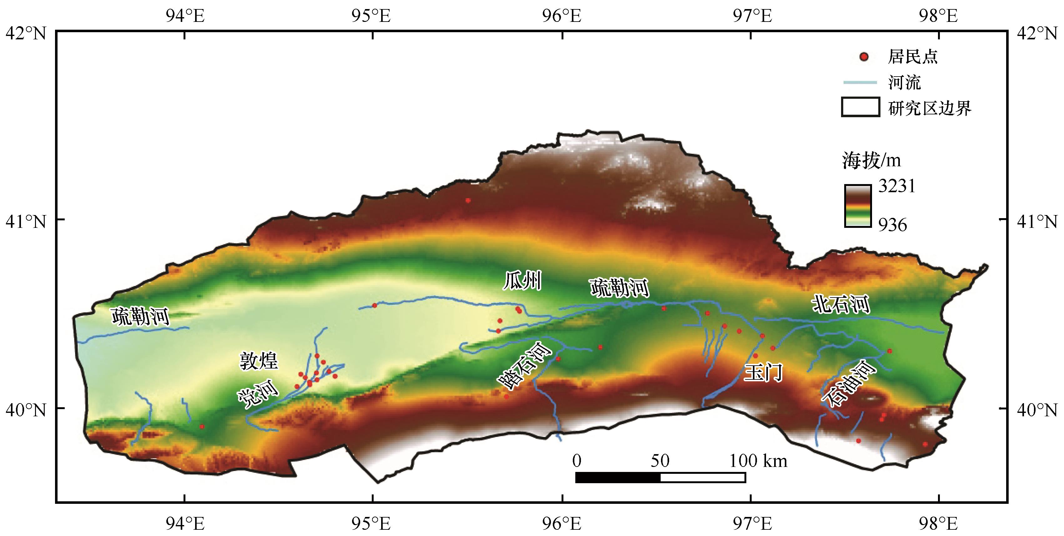
图1 研究区概况
Fig.1 Overview of the studied area
| 指标 | 类别 | 描述 | 权重 | 参考文献 |
|---|---|---|---|---|
土壤 含砂量/% | 1 | 含砂量低:<30 | 1.0 | [ |
| 2 | 含砂量较低:40—50 | 1.2 | ||
| 3 | 含砂量较高:50—60 | 1.6 | ||
| 4 | 含砂量高:>60 | 2.0 | ||
| 坡度 /(°) | 1 | 非常平缓:<6 | 1.0 | [ |
| 2 | 较平缓:6—18 | 1.2 | ||
| 3 | 较陡峭:18—35 | 1.5 | ||
| 4 | 非常陡峭:>35 | 2.0 | ||
有机质 含量/% | 1 | 有机质含量较高:>3 | 1.0 | [ |
| 2 | 有机质含量较好:2—3 | 1.3 | ||
| 3 | 有机质含量较低:1—2 | 1.6 | ||
| 4 | 有机质含量极低:<1 | 2.0 |
表1 土壤指标的类别及权重
Table 1 Classes and assigned weights for soil indices
| 指标 | 类别 | 描述 | 权重 | 参考文献 |
|---|---|---|---|---|
土壤 含砂量/% | 1 | 含砂量低:<30 | 1.0 | [ |
| 2 | 含砂量较低:40—50 | 1.2 | ||
| 3 | 含砂量较高:50—60 | 1.6 | ||
| 4 | 含砂量高:>60 | 2.0 | ||
| 坡度 /(°) | 1 | 非常平缓:<6 | 1.0 | [ |
| 2 | 较平缓:6—18 | 1.2 | ||
| 3 | 较陡峭:18—35 | 1.5 | ||
| 4 | 非常陡峭:>35 | 2.0 | ||
有机质 含量/% | 1 | 有机质含量较高:>3 | 1.0 | [ |
| 2 | 有机质含量较好:2—3 | 1.3 | ||
| 3 | 有机质含量较低:1—2 | 1.6 | ||
| 4 | 有机质含量极低:<1 | 2.0 |
| 类别 | 植被盖度/% | 权重 |
|---|---|---|
| 1 | 高:>20 | 1.0 |
| 2 | 中:10—20 | 1.5 |
| 3 | 低:<10 | 2.0 |
表2 植被指标的类别及权重[22,28]
Table 2 Classes and assigned weights for vegetation index[22,28]
| 类别 | 植被盖度/% | 权重 |
|---|---|---|
| 1 | 高:>20 | 1.0 |
| 2 | 中:10—20 | 1.5 |
| 3 | 低:<10 | 2.0 |
| 指标 | 类别 | 描述 | 权重 | 参考文献 |
|---|---|---|---|---|
| 降水量/mm | 1 | 较多:>100 | 1.0 | [ |
| 2 | 中:50—100 | 1.5 | ||
| 3 | 少:<50 | 2.0 | ||
| 地表温度/℃ | 1 | 低:<10 | 1.0 | — |
| 2 | 中:10—15 | 1.3 | ||
| 3 | 高:15—20 | 1.6 | ||
| 4 | 极高:>20 | 2.0 | ||
| 蒸散发量/mm | 1 | 低:<300 | 1.0 | [ |
| 2 | 中:300—500 | 1.5 | ||
| 3 | 高:>500 | 2.0 |
表3 气候指标的类别及权重
Table 3 Classes and assigned weights for climate indices
| 指标 | 类别 | 描述 | 权重 | 参考文献 |
|---|---|---|---|---|
| 降水量/mm | 1 | 较多:>100 | 1.0 | [ |
| 2 | 中:50—100 | 1.5 | ||
| 3 | 少:<50 | 2.0 | ||
| 地表温度/℃ | 1 | 低:<10 | 1.0 | — |
| 2 | 中:10—15 | 1.3 | ||
| 3 | 高:15—20 | 1.6 | ||
| 4 | 极高:>20 | 2.0 | ||
| 蒸散发量/mm | 1 | 低:<300 | 1.0 | [ |
| 2 | 中:300—500 | 1.5 | ||
| 3 | 高:>500 | 2.0 |
| 土地利用类别 | 土地利用描述 | 权重 | 参考文献 |
|---|---|---|---|
| 1 | 居民地、水域、沼泽地、林地、裸岩 | 1.0 | [ |
| 2 | 耕地、滩地、工矿用地、戈壁 | 1.2 | |
| 3 | 草地、盐碱地、裸土 | 1.6 | |
| 4 | 沙地 | 2.0 |
表4 管理指标的类别及权重
Table 4 Classes and assigned weights for management index
| 土地利用类别 | 土地利用描述 | 权重 | 参考文献 |
|---|---|---|---|
| 1 | 居民地、水域、沼泽地、林地、裸岩 | 1.0 | [ |
| 2 | 耕地、滩地、工矿用地、戈壁 | 1.2 | |
| 3 | 草地、盐碱地、裸土 | 1.6 | |
| 4 | 沙地 | 2.0 |
| 敏感性等级 | 土地荒漠化敏感性指数DSI |
|---|---|
| 极低 | <1.391 |
| 较低 | 1.391—1.515 |
| 较高 | 1.515—1.656 |
| 极高 | >1.656 |
表5 荒漠化敏感性分级
Table 5 Classes and ranges of desertification sensitivity index
| 敏感性等级 | 土地荒漠化敏感性指数DSI |
|---|---|
| 极低 | <1.391 |
| 较低 | 1.391—1.515 |
| 较高 | 1.515—1.656 |
| 极高 | >1.656 |
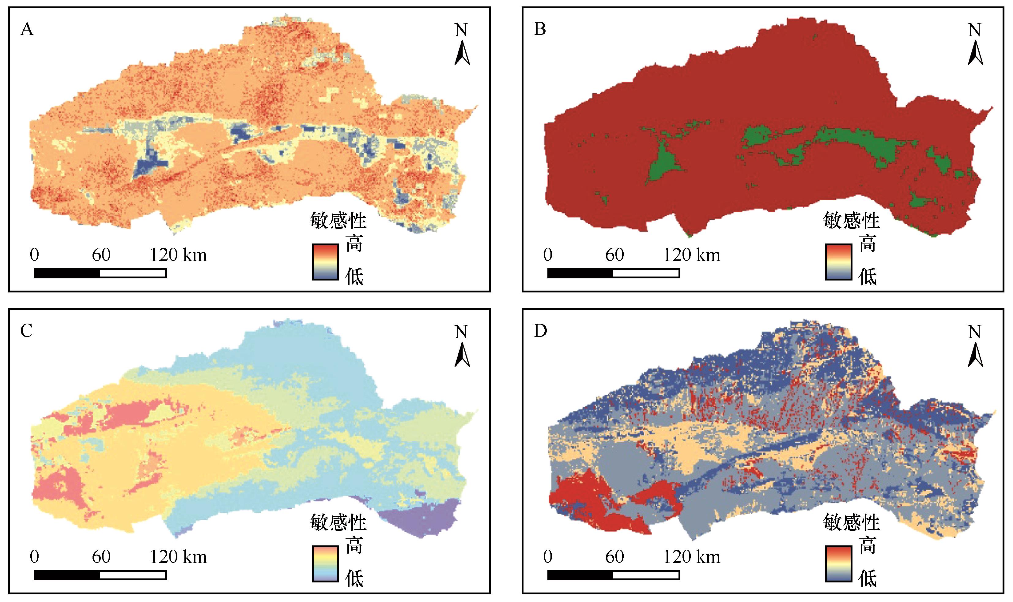
图2 土壤质量指数(A)、植被质量指数(B)、气候质量指数(C)和管理质量指数(D)
Fig.2 Soil quality index (A), vegetation quality index (B), climate quality index (C) and management quality index (D)
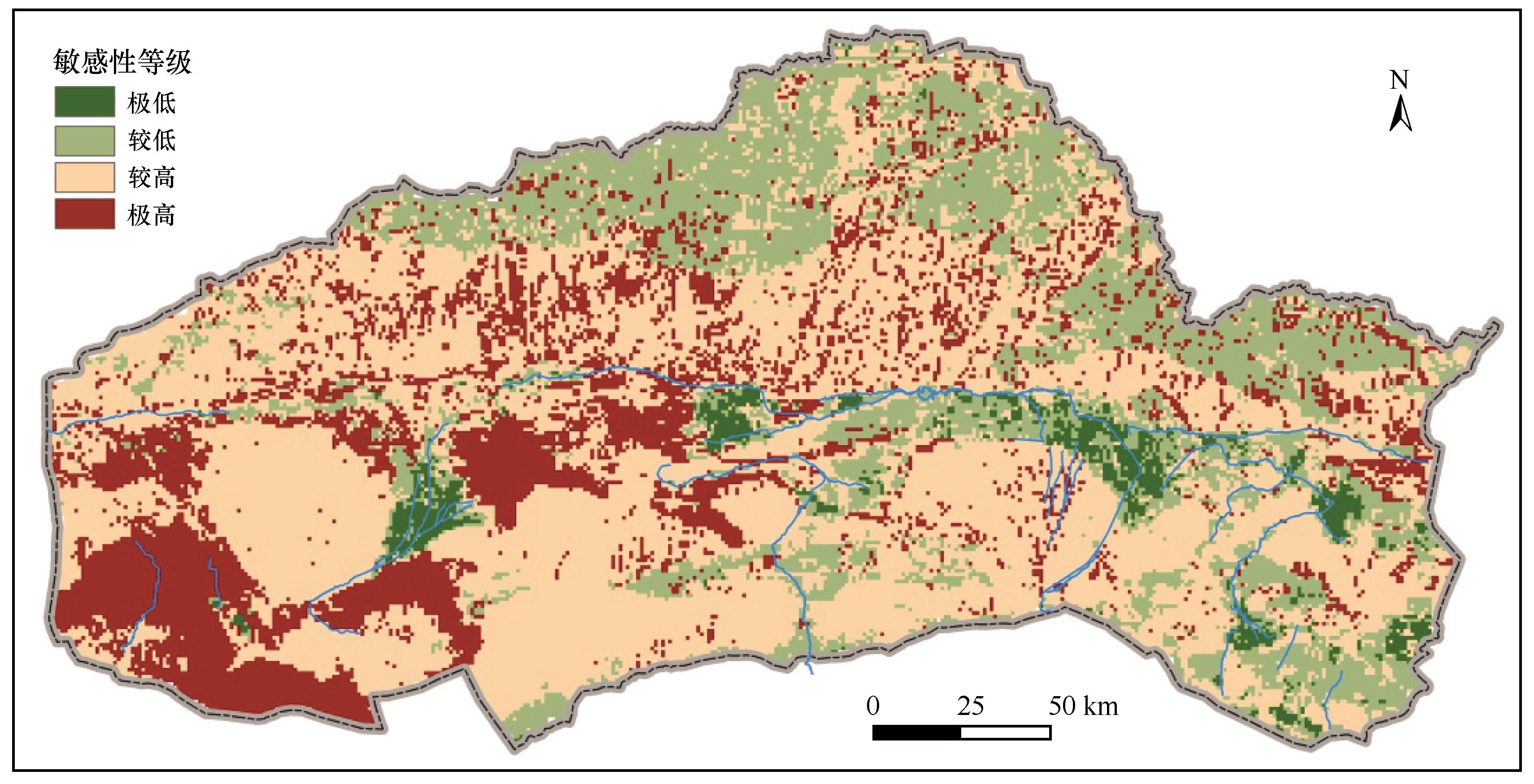
图3 土地荒漠化敏感性空间分布
Fig.3 Spatial distribution of land desertification sensitivity
| 指标 | 土壤质量指数SQI | 气候质量指数CQI | 植被质量指数VQI | 管理质量指数MQI |
|---|---|---|---|---|
| 变异系数 | 0.062 | 0.087 | 0.080 | 0.237 |
| 权重 | 0.133 | 0.187 | 0.172 | 0.508 |
表6 各指标因子的变异系数与权重
Table 6 The variation coefficient and weights of each index
| 指标 | 土壤质量指数SQI | 气候质量指数CQI | 植被质量指数VQI | 管理质量指数MQI |
|---|---|---|---|---|
| 变异系数 | 0.062 | 0.087 | 0.080 | 0.237 |
| 权重 | 0.133 | 0.187 | 0.172 | 0.508 |
| 1 | 董光荣,申建友,金炯,等.关于“荒漠化”与“沙漠化”的概念[J].干旱区地理,1988,11(1):58-61. |
| 2 | 王涛,朱震达.我国沙漠化研究的若干问题:1.沙漠化的概念及其内涵[J].中国沙漠,2003,23(3):3-8. |
| 3 | 董玉祥.沙漠化灾害现状与损失评估[J].灾害学,1993,8(1):13-18. |
| 4 | 屠志方,李梦先,孙涛.第五次全国荒漠化和沙化监测结果及分析[J].林业资源管理,2016,45(1):1-5,13. |
| 5 | 董光荣,高尚玉,金炯,等.青海共和盆地土地沙漠化及其防治[J].中国沙漠,1989,9(1):64-78. |
| 6 | 石建忠,陈翔舜,张龙生,等.甘肃省土地荒漠化状况及分析[J].环境科学学报,2006,26(9):1539-1544. |
| 7 | 王建宏,张龙生,尚立照.甘肃省沙漠化监测结果[J].中国沙漠,2005,25(5):775-779. |
| 8 | 刘爱霞,王长耀,王静,等.基于MODIS和NOAA/AVHRR的荒漠化遥感监测方法[J].农业工程学报,2007,23(10):145-150,293. |
| 9 | 陈丽红.1987-2017年疏勒河中下游土地沙化时空演化特征及其驱动因素研究[D].兰州:西北师范大学,2020. |
| 10 | 胡光印,董治宝,逯军峰,等.近30 a来长江源区沙漠化时空演变过程及成因分析[J].干旱区地理,2011,34(2):300-308. |
| 11 | 高尚武,王葆芳,朱灵益,等.中国沙质荒漠化土地监测评价指标体系[J].林业科学,1998,34(2):3-12. |
| 12 | 韩兰英,万信,方峰,等.甘肃河西地区沙漠化遥感监测评估[J].干旱区地理,2013,36(1):131-138. |
| 13 | 赵明月,赵文武,靳婷,等.青海湖流域土地沙漠化敏感性评价[J].中国农学通报,2012,28(32):237-242. |
| 14 | 刘康,徐卫华,欧阳志云,等.基于GIS的甘肃省土地沙漠化敏感性评价[J].水土保持通报,2002,22(5):29-31,35. |
| 15 | 田璐,邱思静,彭建,等.基于PSR框架的内蒙古自治区沙漠化敏感性评估[J].地理科学进展,2018,37(12):1682-1692. |
| 16 | 潘玉豪,陈云皓,张旭晨,等.宁夏土地荒漠化敏感度时空变化分析[J].北京师范大学学报(自然科学版),2020,56(4):582-590. |
| 17 | 魏婷婷.荒漠化评价研究综述[J].安徽农业科学,2011,39(25):15597-15599. |
| 18 | 郭瑞霞,管晓丹,张艳婷.我国荒漠化主要研究进展[J].干旱气象,2015,33(3):505-513. |
| 19 | 谢徽,郭浩.荒漠化监测与评估指标体系研究进展[J].世界林业研究,2015,28(1):7-11. |
| 20 | Ladisa G, Todorovic M, Liuzzi G T.A GIS-based approach for desertification risk assessment in Apulia region,SE Italy[J].Physics and Chemistry of the Earth,Parts A/B/C,2012,49:103-113. |
| 21 | Sepehr A, Hassanli A M, Ekhtesasi M R,et al.Quantitative assessment of desertification in south of Iran using MEDALUS method[J].Environmental Monitoring and Assessment,2007,134(1):243-254. |
| 22 | Farajzadeh M, Egbal M N.Evaluation of MEDALUS model for desertification hazard zonation using GIS; study area:Iyzad Khast Plain,Iran[J].Pakistan Journal of Biological Sciences,2007,10(16):2622-2630. |
| 23 | Plaiklang S, Sutthivanich I, Sritarapipat T,et al.Desertification assessment using MEDALUS model in upper Lamchiengkrai Watershed,Thailand[J].ISPRS-International Archives of the Photogrammetry,Remote Sensing and Spatial Information Sciences,2020,XLIII-B3-2020:1257-1262. |
| 24 | 沈亚楠,仇梦梦,岳耀杰.中国北方土地沙漠化灾害危险性评价[J].干旱区研究,2017,34(1):174-184. |
| 25 | 张建香,张多勇,刘万锋,等.基于ESAI的黄土高原荒漠化风险评估[J].水土保持通报,2017,37(2):339-344,353. |
| 26 | 齐敬辉.疏勒河流域绿洲生态演变研究[D].兰州:兰州大学,2017. |
| 27 | 丁宏伟,尹政,李爱军,等.疏勒河流域水资源特征及开发利用存在的问题[J].干旱区资源与环境,2002,16(1):48-54. |
| 28 | Lahlaoi H, Rhinane H, Hilali A,et al.Desertification assessment using MEDALUS Model in Watershed Oued El Maleh,Morocco[J].Geosciences,2017,7(3):1-16. |
| 29 | Lamqadem A A, Pradhan B, Saber H,et al.Desertification sensitivity analysis using MEDALUS Model and GIS:a case study of the Oases of Middle Draa Valley,Morocco[J].Sensors,2018,18(7):1-19. |
| 30 | Ferrara A, Kosmas C, Salvati L,et al.Updating the MEDALUS-ESA framework for worldwide land degradation and desertification assessment[J].Land Degradation & Development,2020,31(12):1593-1607. |
| 31 | 曹晓仪,董治宝,李静,等.基于GIS的榆林市土壤风蚀危险度评价[J].水土保持通报,2013,33(1):206-210. |
| 32 | 董光荣,靳鹤龄,王贵勇,等.中国沙漠形成演化与气候变化研究[J].中国科学院院刊,1999,14(4):276-280. |
| 33 | 王葆芳,贾宝全,杨晓晖,等.干旱区土地利用方式对沙漠化土地恢复能力的评价[J].生态学报,2002,22(12):2030-2035. |
| 34 | 董玉祥.土地沙漠化影响因子的定量分析[J].干旱区研究,1989,6(4):34-42. |
| 35 | 高尚玉,史培军,哈斯,等.我国北方风沙灾害加剧的成因及其发展趋势[J].自然灾害学报,2000,9(3):31-37. |
| 36 | 赵微,林健,王树芳,等.变异系数法评价人类活动对地下水环境的影响[J].环境科学,2013,34(4):1277-1283. |
| 37 | 刘轩,岳德鹏,马梦超.基于变异系数法的北京市山区小流域生态环境质量评价[J].西北林学院学报,2016,31(2):66-71,294. |
| 38 | 宁亚洲,张福平,冯起,等.基于SEBAL模型的疏勒河流域蒸散发估算与灌溉效率评价[J].干旱区地理,2020,43(4):928-938. |
| 39 | 马仲武,王新源,王小军,等.甘肃省酒泉市土地沙漠化现状及动态分析[J].中国农业资源与区划,2018,39(3):141-147. |
| 40 | 李晓婧,白艳萍,李萌,等.河西走廊水资源变化与生态环境时空关联分析[J].水土保持通报,2019,39(2):275-280,287. |
| 41 | 杨雪梅.气候变暖背景下河西地区荒漠植被变化研究(1982-2013)[D].兰州:兰州大学,2015. |
| [1] | 姜吴彬, 张德国, 杨小平. 沙丘形态及表沙粒度特征对风况和地表植被变化的响应[J]. 中国沙漠, 2022, 42(4): 120-129. |
| [2] | 张克存, 安志山, 何明珠, 肖建华, 张宏雪. 中国沙区公路风沙危害及防治研究进展[J]. 中国沙漠, 2022, 42(3): 222-232. |
| [3] | 解锡豪, 李志忠, 靳建辉, 刘瑞, 邹晓君, 马运强. 古尔班通古特沙漠东南部植被线形沙丘内部构造及发育模式[J]. 中国沙漠, 2022, 42(3): 74-84. |
| [4] | 高冲, 董治宝, 南维鸽, 刘铮瑶, 朱春鸣, 王晓枝, 肖南, 张欣. 古尔班通古特沙漠蜂窝状沙丘沉积物理化特征及沉积环境[J]. 中国沙漠, 2022, 42(2): 14-24. |
| [5] | 董苗, 严平, 王晓旭, 张国明, 孟小楠, 纪欣然, 王勇. 雅鲁藏布江山南宽谷段爬坡沙丘表层沉积物特征[J]. 中国沙漠, 2022, 42(2): 153-163. |
| [6] | 落桑曲加, 张焱, 马鹏飞, 扎多, 格多, 张正偲. 雅鲁藏布江中游不同地表输沙量特征[J]. 中国沙漠, 2022, 42(2): 6-13. |
| [7] | 颜明, 张应华, 贺莉, 程维明, 王随继, 许炯心. 无定河上游河道对沙漠化的阻截效应[J]. 中国沙漠, 2022, 42(2): 62-68. |
| [8] | 王涛. 中国防沙治沙实践与沙漠科学发展的70年——Ⅰ.初创篇[J]. 中国沙漠, 2022, 42(1): 1-4. |
| [9] | 杨林. 海岸沙丘形态对季风/台风的协同响应研究现状与展望[J]. 中国沙漠, 2022, 42(1): 108-113. |
| [10] | 董玉祥, 李志忠. 近40年中国海岸风沙地貌研究回顾[J]. 中国沙漠, 2022, 42(1): 12-22. |
| [11] | 殷婕, 哈斯额尔敦null, 安晶, 周炎广, 胡日娜, 武子丰. 鄂尔多斯高原油蒿(Artemisia ordosica)灌丛沙堆风沙气流结构及其地貌学意义[J]. 中国沙漠, 2022, 42(1): 184-195. |
| [12] | 李志忠, 靳建辉, 刘瑞, 解锡豪, 邹晓君, 马运强, 谭典佳. 古尔班通古特沙漠风沙地貌研究进展评述[J]. 中国沙漠, 2022, 42(1): 41-47. |
| [13] | 赵晖, 杨宏宇, 王兴繁, 汪克奇. 巴丹吉林沙漠典型沉积物年代学研究评述[J]. 中国沙漠, 2022, 42(1): 57-65. |
| [14] | 杨旭艳, 董治宝, 杨勤科, 李超. 基于DEM的地球与火星格状沙丘对比分析[J]. 中国沙漠, 2021, 41(6): 88-98. |
| [15] | 潘美慧, 郝泽文, 齐宇涵, 杨安娜, 陈有桂, 李晨露. 西藏朋曲流域不同地貌部位流动沙丘粒度特征[J]. 中国沙漠, 2021, 41(6): 138-147. |
| 阅读次数 | ||||||
|
全文 |
|
|||||
|
摘要 |
|
|||||
©2018中国沙漠 编辑部
地址: 兰州市天水中路8号 (730000)
电话:0931-8267545
Email:caiedit@lzb.ac.cn;desert@lzb.ac.cn

 甘公网安备 62010202000688号