| 1 |
Page K J.Riverine source bordering sand dune[J].Australian Geographer,1971,11(6):603-605.
|
| 2 |
李森,王跃,哈斯,等.雅鲁藏布江河谷风沙地貌分类与发育问题[J].中国沙漠,1997,17(4):342-350.
|
| 3 |
Bullard J E, Livingstone I.Interactions between aeolian and fluvial systems in dryland environments[J].Area,2002,34(1):8-16.
|
| 4 |
Yan P, Li X M, Ma Y F,et al.Morphological characteristics of interactions between deserts and rivers in northern China[J].Aeolian Research,2015,19:225-233.
|
| 5 |
刘宇慧,韩广,朱孟娜,等.科尔沁沙地西部响水河河水与其河岸相互作用的初步研究[J].干旱区地理,2017,40(1):94-101.
|
| 6 |
董治宝.青藏高原风沙地貌图集[M].西安:地图出版社,2017:14-15.
|
| 7 |
Mckee E D, Bigarella J J.Deformational structures in Brazilian coastal dunes[J].Journal of Sedimentary Research,1972,42(3):670-681.
|
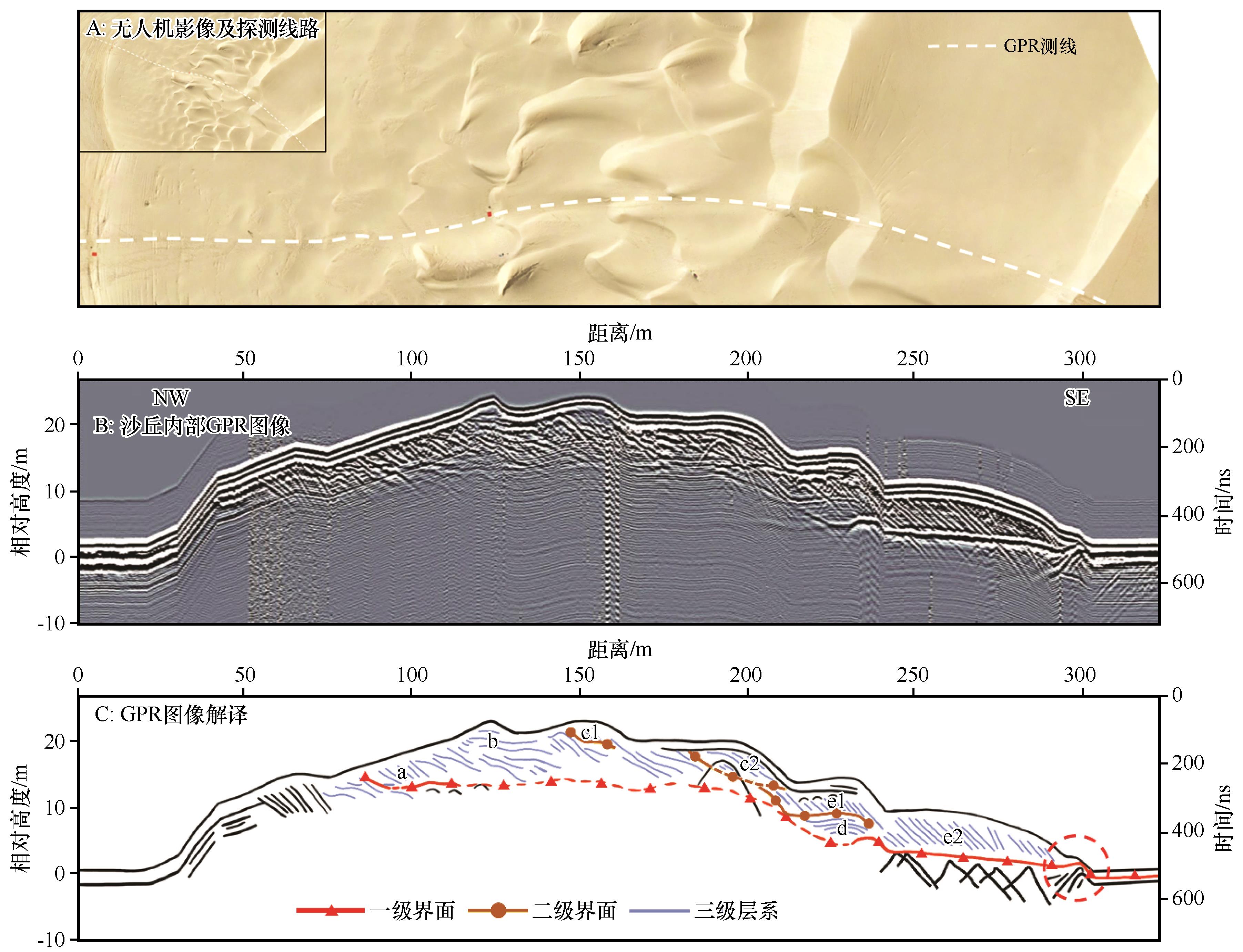
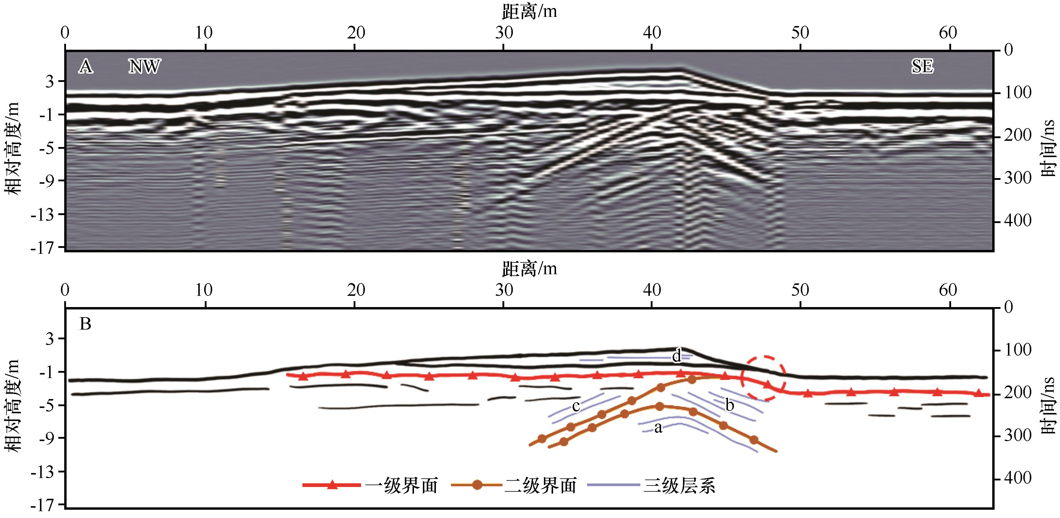
| 8 |
Bristow C S, Jol H M.An introduction to ground penetrating radar (GPR) in sediments[J].Geological Society London Special Publications,2003,211(1):1-7.
|
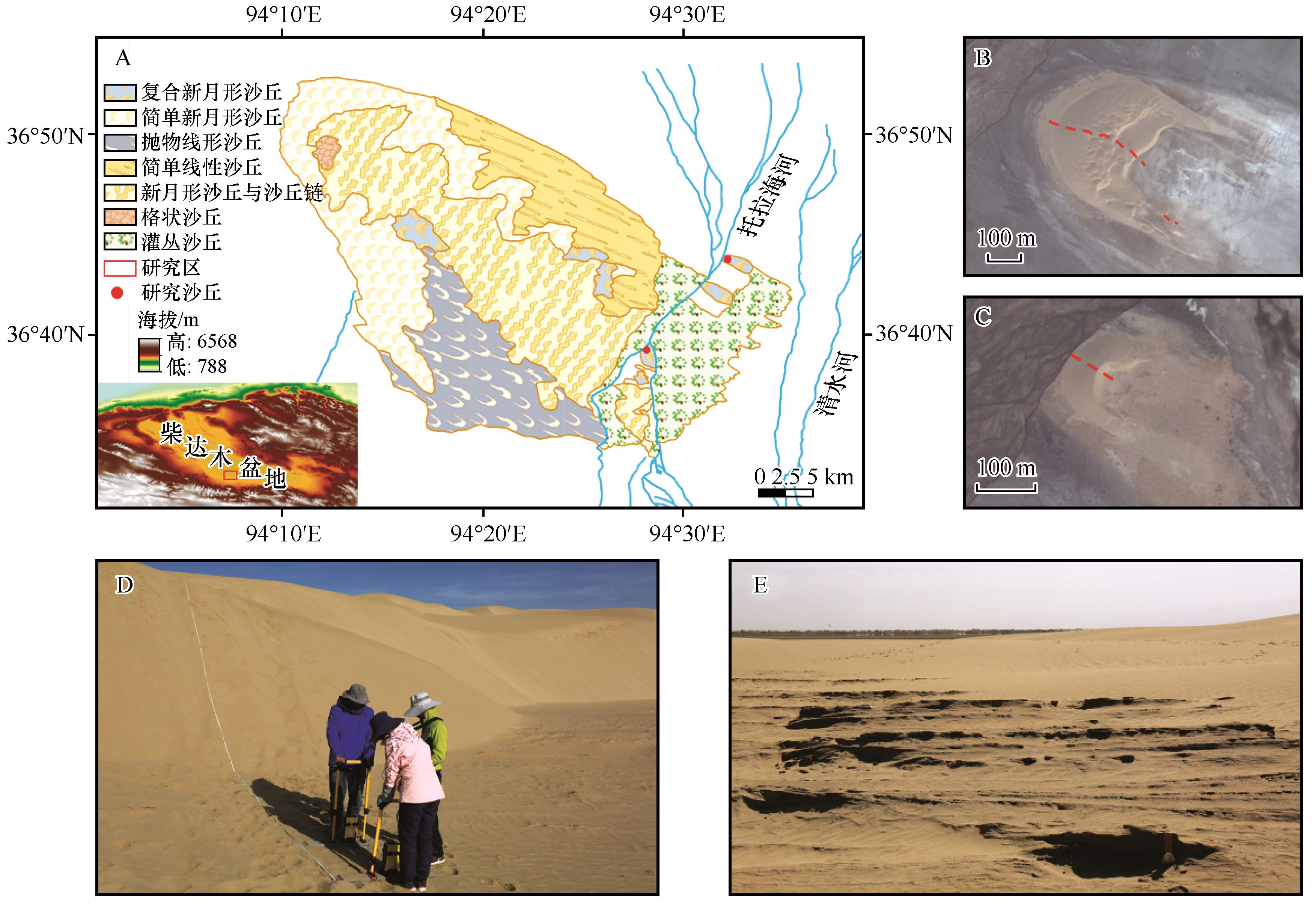
| 9 |
Davis J L, Annan A P.Ground penetrating radar for high resolution mapping of soil and rock stratigraphy[J].Geophysical Prospecting,1989,37(5):531-551.
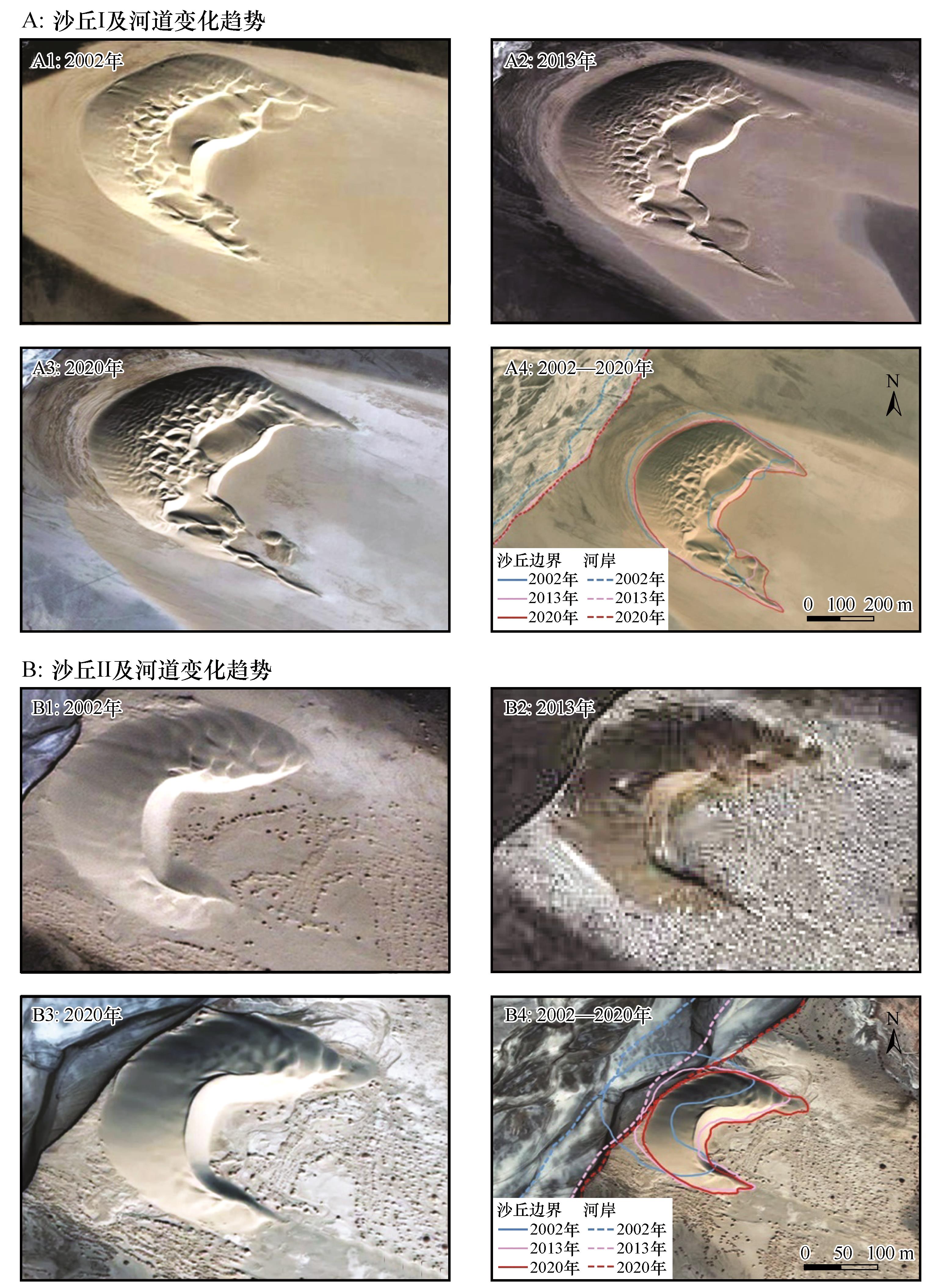
|
| 10 |
Harari Z.Ground-penetrating radar (GPR) for imaging stratigraphic features and groundwater in sand dunes[J].Journal of Applied Geophysics,1996,36(1):43-52.
|
| 11 |
Bristow C S, Chroston P N, Bailey S D.The structure and development of foredunes on a locally prograding coast:insights from ground-penetrating radar surveys,Norfolk,UK[J].Sedimentology,2000,47(5):923-944.
|
| 12 |
Jol H M, Bristow C S.GPR in sediments:advice on data collection,basic processing and interpretation,a good practice guide[J].Geological Society London Special Publications,2003,211(1):9-27.
|
| 13 |
Ribolini A, Bertoni D, Bini M,et al.Ground-penetrating radar prospections to image the inner structure of coastal dunes at sites characterized by erosion and accretion (Northern Tuscany,Italy)[J].Applied Sciences,2021,11(23):11260.
|
| 14 |
Dadalto T P, Carvalho B C, Guerra J V,et al.Holocene morpho-sedimentary evolution of Marambaia Barrier Island (SE Brazil)[J].Quaternary Research,2022,105:182-200.
|
| 15 |
唐文武,朱大奎,葛晨东,等.探地雷达(GPR)在海岸环境勘测中的应用[J].海洋地质与第四纪地质,2001,21(2):99-105.
|
| 16 |
俞祁浩,屈建军,郑本兴,等.探地雷达在沙漠研究中的应用[J].中国沙漠,2004,24(3):371-375.
|
| 17 |
傅天阳,李孝泽.探地雷达在沙漠研究中的应用综述[J].中国沙漠,2014,34(1):49-55.
|
| 18 |
姜锋,李志忠,靳建辉,等.基于GPR图像的河北昌黎海岸横向沙脊北段沉积构造及其成因[J].地理研究,2015,34(8):1559-1568.
|
| 19 |
靳建辉,李志忠,胡凡根,等.全新世中晚期福建海岸沙丘记录的海岸环境与人类活动[J].地理学报,2015,70(5):751-765.
|
| 20 |
洪东铭,邓涛,李志忠,等.福建长乐海岸沙丘沉积序列记录的海岸环境演变[J].河北师范大学学报(自然科学版),2017,41(2):172-179.
|
| 21 |
李孝泽,王振亭,陈发虎,等.巴丹吉林沙漠横向沙山沉积GPR雷达探测研究[J].第四纪研究,2009,29(4):797-805.
|
| 22 |
刘瑞,李志忠,靳建辉,等.古尔班通古特沙漠西南缘新月形沙丘内部沉积构造特征研究[J].干旱区地理,2022,45(3):802-813.
|
| 23 |
解锡豪,李志忠,靳建辉,等.古尔班通古特沙漠东南部植被线形沙丘内部构造及发育模式[J].中国沙漠,2022,42(3):74-84.
|
| 24 |
Li C, Dong Z B, Cui X J,et al.Pattern analysis of simple transverse dunes in China's Qaidam Basin,north of the Kunlun Mountains[J].Environmental Earth Sciences,2016,75(9):729.
|
| 25 |
裼纫章.柴达木盆地托拉海河西地区的自然景观[J].地理学报,1959,25(6):422-434.
|
| 26 |
董苗,严平,孟小楠,等.青藏高原爬坡沙丘地表沉积物特征分析:以柴达木盆地托拉海河为例[J].水土保持学报,2018,32(4):101-108.
|
| 27 |
段水强.1976-2015年柴达木盆地湖泊演变及其对气候变化和人类活动的响应[J].湖泊科学,2018,30(1):256-265.
|
| 28 |
时兴合,赵燕宁,戴升,等.柴达木盆地40多年来的气候变化研究[J].中国沙漠,2005,25(1):123-128.
|
| 29 |
Woodward J, Ashworth P J, Best J L,et al.The use and application of GPR in sandy fluvial environments:methodological considerations[J].Geological Society London Special Publications,2003,211(1):127-142.
|
| 30 |
Mccann D M, Jackson P D, Fenning P J.Comparison of the seismic and ground probing radar methods in geological surveying[J].IEE Proceedings-F Radar and Signal Processing,1988,135(4):380-390.
|
| 31 |
Medina P Z, Limarino C, Bonomo N,et al.Using Ground Penetrating Radar and attribute analysis for identifying depositional units in a fluvial-aeolian interaction environment:the Guandacol Valley,northwest Argentina[J].Journal of South American Earth Sciences,2020,98:102467.
|
| 32 |
祁兴芬,刘副刚,袁小兰.海岸沙丘的沉积构造及其形成原因的探讨:以秦皇岛市海岸风成沙丘为例[J].海洋地质动态,2008,24(1):9-11.
|
| 33 |
董治宝,李超,吕萍,等.侵蚀型沙丘:来自火星的启示[J].地球科学进展,2021,36(2):125-138.
|
 ), 严平1(


 甘公网安备 62010202000688号