中国沙漠 ›› 2026, Vol. 46 ›› Issue (3): 330-340.DOI: 10.7522/j.issn.1000-694X.2025.00237
王学林( ), 陈江波, 刘昊, 宫航, 王瀚卓, 丁国栋(), 赵媛媛
收稿日期:2025-07-22
修回日期:2025-09-22
出版日期:2026-05-20
发布日期:2026-06-11
通讯作者:
丁国栋
作者简介:王学林(1996—),男,河北邢台人,博士研究生,主要研究方向为荒漠化防治。E-mail: Wangxuelin@bjfu.edu.cn
基金资助:
Xuelin Wang(), Jiangbo Chen, Hao Liu, Hang Gong, Hanzhuo Wang, Guodong Ding(), Yuanyuan Zhao
Received:2025-07-22
Revised:2025-09-22
Online:2026-05-20
Published:2026-06-11
Contact:
Guodong Ding
摘要:
雅鲁藏布江中下游河谷地带广泛发育沙尘沉积地貌,其分布与形成机制具有显著的区域特征。为探究其河谷区不同空间格局的风蚀下垫面沙尘潜在释放能力,选取西藏米林区段的河谷地带,采集林地、草地、耕地、河滩地、固定沙地、流动沙地6种下垫面土壤,通过土壤粒度分析(Particle Size Distribution,PSD)、抗风蚀能力指数(Anti-Erosion Rating Index,AERI)等方法,为该地沙尘环境变化研究和生态恢复管理提供数据支撑。主要结果:(1)河谷区土壤基质的黏粒含量极低(<1%),细砂粒占比最大(39.9%),主要由砂质壤土、壤质砂土和砂土组成,且土壤粒径随土层加深呈现粗化趋势。(2)单重分形维数表现为林地(2.315)>耕地(2.289)>河滩地(2.261)>草地(2.171)>固定沙地(2.165)>流动沙地(2.084),远低于同类型平均数值水平;单重分形维数与土壤有机碳含量极其显著正相关(P<0.001),与全磷、速效磷、全氮含量极显著正相关(P<0.01),体现了细颗粒(黏粒、粉粒)通过物理化学作用形成的养分富集效应。(3)土壤AERI存在显著空间差异(P<0.05),林地(1.086)>耕地(1.012)>草地(0.955)>固定沙地(0.856)>河滩地(0.711)>流动沙地(0.675),植被和农业改善了土壤性状,而砂质裸露地表(砂粒含量>85%)抗蚀能力最弱。综上,利用分形理论可表征不同类型的下垫面土壤质量水平与演变规律,有助于为雅江中下游流域河谷地带的沙尘释放研究和土壤质地改善提供数据支撑。
中图分类号:
王学林, 陈江波, 刘昊, 宫航, 王瀚卓, 丁国栋, 赵媛媛. 雅鲁藏布江中下游宽谷地带土壤粒径分形维数及抗风蚀能力[J]. 中国沙漠, 2026, 46(3): 330-340.
Xuelin Wang, Jiangbo Chen, Hao Liu, Hang Gong, Hanzhuo Wang, Guodong Ding, Yuanyuan Zhao. Fractal dimension characteristics of soil particle size distribution and wind erosion resistance in the middle-lower reaches of the Yarlung Zangbo River wide valley[J]. Journal of Desert Research, 2026, 46(3): 330-340.
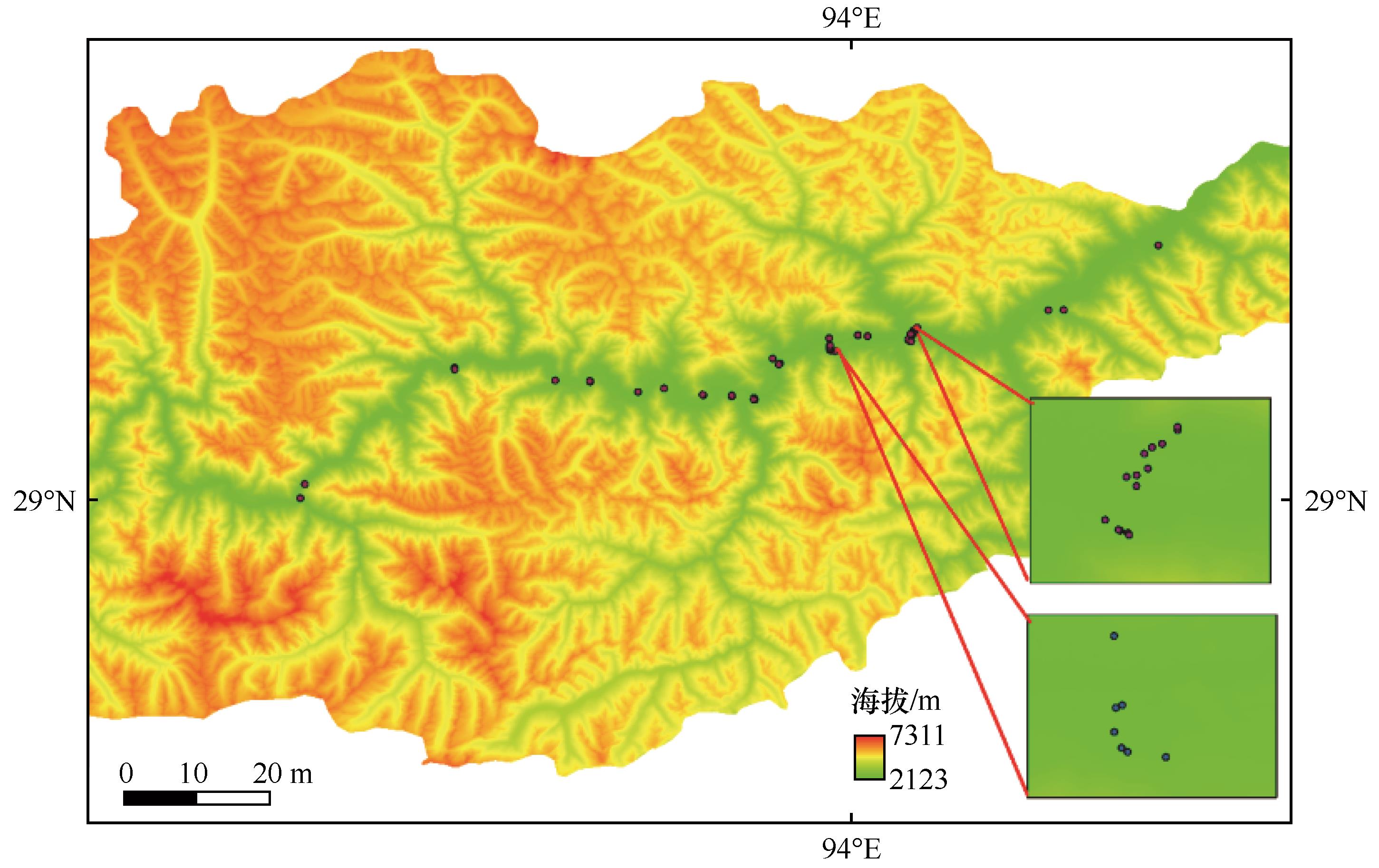
图1 研究区采样点分布
Fig.1 Sampling distribution map of the study area
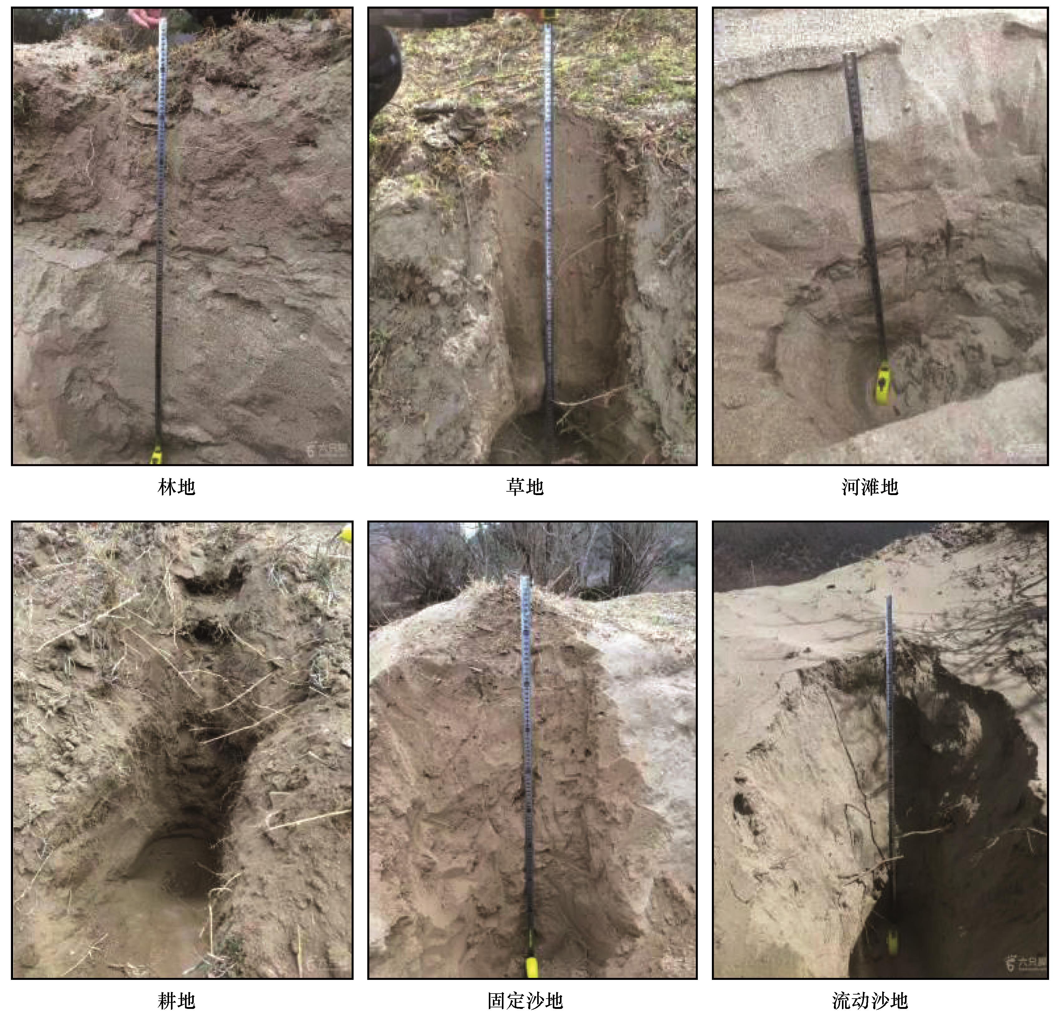
图2 采样点剖面示意图
Fig.2 Schematic diagram of sampling point profile
| 下垫面类型 | 土壤深度/cm | 土壤颗粒组成/% | ||||||
|---|---|---|---|---|---|---|---|---|
| 黏粒 | 粉粒 | 极细砂 | 细砂粒 | 中砂粒 | 粗砂粒 | 极粗砂粒 | ||
| <0.002 mm | 0.002~0.05 mm | 0.05~0.10 mm | 0.10~0.25 mm | 0.25~0.5 mm | 0.5~1 mm | 1~2 mm | ||
| 草地 | 0~20 | 0.62±0.6ab | 22.82±16.1ab | 24.1±7.13a | 34.34±13.75a | 14.27±9.57ab | 3.5±3.13a | 0.24±0.37a |
| 20~40 | 0.56±0.6a | 20.19±13.6a | 21.81±9.27a | 31.18±10.23a | 12.32±3.6a | 9.4±12.24a | 4.59±9.75a | |
| 40~60 | 0.21±0.3a | 12.19±9.88a | 19.12±12.29a | 37.68±15.29ab | 22.11±16.7a | 7.82±10.91a | 0.87±1.92a | |
| 60~80 | 0.19±0.27ab | 12.1±12.24a | 18.02±13.38a | 42.84±18a | 19.6±14.36a | 5.91±11.37a | 1.28±2.82a | |
| 80~100 | 0.14±0.2a | 11.04±8.82a | 17.98±13.62a | 39.48±22.3a | 18.06±10.13a | 8.76±16.9a | 3.77±8.41a | |
| 林地 | 0~20 | 1.29±1.38a | 32.06±25.69a | 22.78±8.14a | 31.61±20.57a | 10.11±9.37b | 1.92±2.21a | 0.22±0.21a |
| 20~40 | 1.07±1.5a | 28.1±25.94a | 20.24±8.28a | 35.79±24.12a | 11.85±11.5a | 2.23±3.73a | 0.64±1.11a | |
| 40~60 | 0.86±1.23a | 25.27±23.55a | 19.63±11.33a | 33.61±18.89ab | 16.74±17.42a | 3.41±6.09a | 0.42±1.15a | |
| 60~80 | 0.64±0.6a | 24.15±20.4a | 21.79±13.46a | 30.3±17.59a | 14.91±14.93a | 6.68±13.45a | 1.47±3.33a | |
| 80~100 | 0.63±0.68a | 25.16±24.25a | 23.09±14.8a | 30.48±19.23a | 13.85±17.95a | 4.61±8.15a | 1.78±4.96a | |
| 耕地 | 0~20 | 0.5±0.3ab | 26.16±6.36ab | 28.43±11.5a | 30.14±7.5a | 10.87±7.94ab | 3.27±2.78a | 0.59±0.68a |
| 20~40 | 0.49±0.53a | 27.35±10.97a | 25.48±8.89a | 27.99±7.46a | 12.94±8.31a | 4.44±4.08a | 0.59±0.68a | |
| 40~60 | 0.59±0.55a | 29.85±11.16a | 25.87±6.73a | 28.12±9.14b | 12.62±8.33a | 2.88±2.18a | 0.59±0.68a | |
| 60~80 | 0.65±0.38a | 27.8±9.96a | 23.73±7.53a | 29.25±5.1a | 14.88±9.77a | 3.66±3.12a | 0.59±0.68a | |
| 80~100 | 0.59±0.43a | 22.78±8.66a | 24.39±8.14a | 32.82±4.47a | 15.07±11.14a | 3.24±2.35a | 0.59±0.68a | |
| 河滩地 | 0~20 | 0±0b | 6.16±3.7b | 18.7±16.95a | 43.27±13.92a | 25.15±25.1a | 6.61±9.32a | 0.11±0.15a |
| 20~40 | 0±0a | 6.15±1.99a | 18.82±14.28a | 48.73±8.73a | 22.86±20.17a | 3.43±4.8a | 0.02±0.03a | |
| 40~60 | 0.28±0.4a | 13.71±9.74a | 27.79±19.98a | 39.61±8.02ab | 15.33±18.26a | 3.18±3.68a | 0.1±0.14a | |
| 60~80 | 0±0b | 11±3.9a | 29.23±0.14a | 51.69±7.11a | 7.37±2.32a | 0.56±0.79a | 0.14±0.2a | |
| 80~100 | 0.14±0a | 9.05±0a | 35.5±0a | 52.34±0a | 2.98±0a | 0±0a | 0±0a | |
| 固定沙地 | 0~20 | 0.61±0.57ab | 20.08±12.17ab | 28.43±5.7a | 40.55±15.49a | 8.84±5.34b | 1.44±2.06a | 0.03±0.06a |
| 20~40 | 0.36±0.35a | 15.17±8.78a | 26.94±7.41a | 43.29±14.68a | 11.79±9.15a | 2.39±4.42a | 0.06±0.13a | |
| 40~60 | 0.19±0.26a | 12.47±9.75a | 23.82±10.31a | 43.89±14.86ab | 16.07±14.43a | 3.45±6.41a | 0.11±0.25a | |
| 60~80 | 0.19±0.3ab | 11.36±11.09a | 21.42±12.46a | 40.31±17.64a | 18.4±12.46a | 6.66±10.75a | 1.44±4.18a | |
| 80~100 | 0.22±0.34a | 14.36±14.66a | 20.41±14.61a | 37.12±16.77a | 19.17±18.17a | 6.21±10.32a | 2.05±5.2a | |
| 流动沙地 | 0~20 | 0.12±0.26ab | 6.82±8.34ab | 14.83±15.7a | 52.47±22.93a | 17.9±11.37ab | 4.78±9.81a | 2.65±5.93a |
| 20~40 | 0.22±0.4a | 10.08±12.28a | 15.21±16.85a | 52.95±19.37a | 19.77±14.65a | 1.41±2.01a | 0.32±0.72a | |
| 40~60 | 0.16±0.23a | 10.22±11.99a | 15.8±15.72a | 53.63±19.46a | 18.08±13.08a | 1.84±3.04a | 0.29±0.64a | |
| 60~80 | 0.1±0.18ab | 7.71±9.06a | 14.17±17.58a | 51.76±20.88a | 20.46±15.57a | 3.03±4.9a | 2.11±4.73a | |
| 80~100 | 0.2±0.27a | 10.12±12.37a | 16.97±15.4a | 50.44±23.95a | 17.03±10.07a | 3.96±7.33a | 1.28±2.86a | |
表1 6种下垫面的土壤颗粒组成
Table 1 Soil particle composition for six underlying surfaces
| 下垫面类型 | 土壤深度/cm | 土壤颗粒组成/% | ||||||
|---|---|---|---|---|---|---|---|---|
| 黏粒 | 粉粒 | 极细砂 | 细砂粒 | 中砂粒 | 粗砂粒 | 极粗砂粒 | ||
| <0.002 mm | 0.002~0.05 mm | 0.05~0.10 mm | 0.10~0.25 mm | 0.25~0.5 mm | 0.5~1 mm | 1~2 mm | ||
| 草地 | 0~20 | 0.62±0.6ab | 22.82±16.1ab | 24.1±7.13a | 34.34±13.75a | 14.27±9.57ab | 3.5±3.13a | 0.24±0.37a |
| 20~40 | 0.56±0.6a | 20.19±13.6a | 21.81±9.27a | 31.18±10.23a | 12.32±3.6a | 9.4±12.24a | 4.59±9.75a | |
| 40~60 | 0.21±0.3a | 12.19±9.88a | 19.12±12.29a | 37.68±15.29ab | 22.11±16.7a | 7.82±10.91a | 0.87±1.92a | |
| 60~80 | 0.19±0.27ab | 12.1±12.24a | 18.02±13.38a | 42.84±18a | 19.6±14.36a | 5.91±11.37a | 1.28±2.82a | |
| 80~100 | 0.14±0.2a | 11.04±8.82a | 17.98±13.62a | 39.48±22.3a | 18.06±10.13a | 8.76±16.9a | 3.77±8.41a | |
| 林地 | 0~20 | 1.29±1.38a | 32.06±25.69a | 22.78±8.14a | 31.61±20.57a | 10.11±9.37b | 1.92±2.21a | 0.22±0.21a |
| 20~40 | 1.07±1.5a | 28.1±25.94a | 20.24±8.28a | 35.79±24.12a | 11.85±11.5a | 2.23±3.73a | 0.64±1.11a | |
| 40~60 | 0.86±1.23a | 25.27±23.55a | 19.63±11.33a | 33.61±18.89ab | 16.74±17.42a | 3.41±6.09a | 0.42±1.15a | |
| 60~80 | 0.64±0.6a | 24.15±20.4a | 21.79±13.46a | 30.3±17.59a | 14.91±14.93a | 6.68±13.45a | 1.47±3.33a | |
| 80~100 | 0.63±0.68a | 25.16±24.25a | 23.09±14.8a | 30.48±19.23a | 13.85±17.95a | 4.61±8.15a | 1.78±4.96a | |
| 耕地 | 0~20 | 0.5±0.3ab | 26.16±6.36ab | 28.43±11.5a | 30.14±7.5a | 10.87±7.94ab | 3.27±2.78a | 0.59±0.68a |
| 20~40 | 0.49±0.53a | 27.35±10.97a | 25.48±8.89a | 27.99±7.46a | 12.94±8.31a | 4.44±4.08a | 0.59±0.68a | |
| 40~60 | 0.59±0.55a | 29.85±11.16a | 25.87±6.73a | 28.12±9.14b | 12.62±8.33a | 2.88±2.18a | 0.59±0.68a | |
| 60~80 | 0.65±0.38a | 27.8±9.96a | 23.73±7.53a | 29.25±5.1a | 14.88±9.77a | 3.66±3.12a | 0.59±0.68a | |
| 80~100 | 0.59±0.43a | 22.78±8.66a | 24.39±8.14a | 32.82±4.47a | 15.07±11.14a | 3.24±2.35a | 0.59±0.68a | |
| 河滩地 | 0~20 | 0±0b | 6.16±3.7b | 18.7±16.95a | 43.27±13.92a | 25.15±25.1a | 6.61±9.32a | 0.11±0.15a |
| 20~40 | 0±0a | 6.15±1.99a | 18.82±14.28a | 48.73±8.73a | 22.86±20.17a | 3.43±4.8a | 0.02±0.03a | |
| 40~60 | 0.28±0.4a | 13.71±9.74a | 27.79±19.98a | 39.61±8.02ab | 15.33±18.26a | 3.18±3.68a | 0.1±0.14a | |
| 60~80 | 0±0b | 11±3.9a | 29.23±0.14a | 51.69±7.11a | 7.37±2.32a | 0.56±0.79a | 0.14±0.2a | |
| 80~100 | 0.14±0a | 9.05±0a | 35.5±0a | 52.34±0a | 2.98±0a | 0±0a | 0±0a | |
| 固定沙地 | 0~20 | 0.61±0.57ab | 20.08±12.17ab | 28.43±5.7a | 40.55±15.49a | 8.84±5.34b | 1.44±2.06a | 0.03±0.06a |
| 20~40 | 0.36±0.35a | 15.17±8.78a | 26.94±7.41a | 43.29±14.68a | 11.79±9.15a | 2.39±4.42a | 0.06±0.13a | |
| 40~60 | 0.19±0.26a | 12.47±9.75a | 23.82±10.31a | 43.89±14.86ab | 16.07±14.43a | 3.45±6.41a | 0.11±0.25a | |
| 60~80 | 0.19±0.3ab | 11.36±11.09a | 21.42±12.46a | 40.31±17.64a | 18.4±12.46a | 6.66±10.75a | 1.44±4.18a | |
| 80~100 | 0.22±0.34a | 14.36±14.66a | 20.41±14.61a | 37.12±16.77a | 19.17±18.17a | 6.21±10.32a | 2.05±5.2a | |
| 流动沙地 | 0~20 | 0.12±0.26ab | 6.82±8.34ab | 14.83±15.7a | 52.47±22.93a | 17.9±11.37ab | 4.78±9.81a | 2.65±5.93a |
| 20~40 | 0.22±0.4a | 10.08±12.28a | 15.21±16.85a | 52.95±19.37a | 19.77±14.65a | 1.41±2.01a | 0.32±0.72a | |
| 40~60 | 0.16±0.23a | 10.22±11.99a | 15.8±15.72a | 53.63±19.46a | 18.08±13.08a | 1.84±3.04a | 0.29±0.64a | |
| 60~80 | 0.1±0.18ab | 7.71±9.06a | 14.17±17.58a | 51.76±20.88a | 20.46±15.57a | 3.03±4.9a | 2.11±4.73a | |
| 80~100 | 0.2±0.27a | 10.12±12.37a | 16.97±15.4a | 50.44±23.95a | 17.03±10.07a | 3.96±7.33a | 1.28±2.86a | |
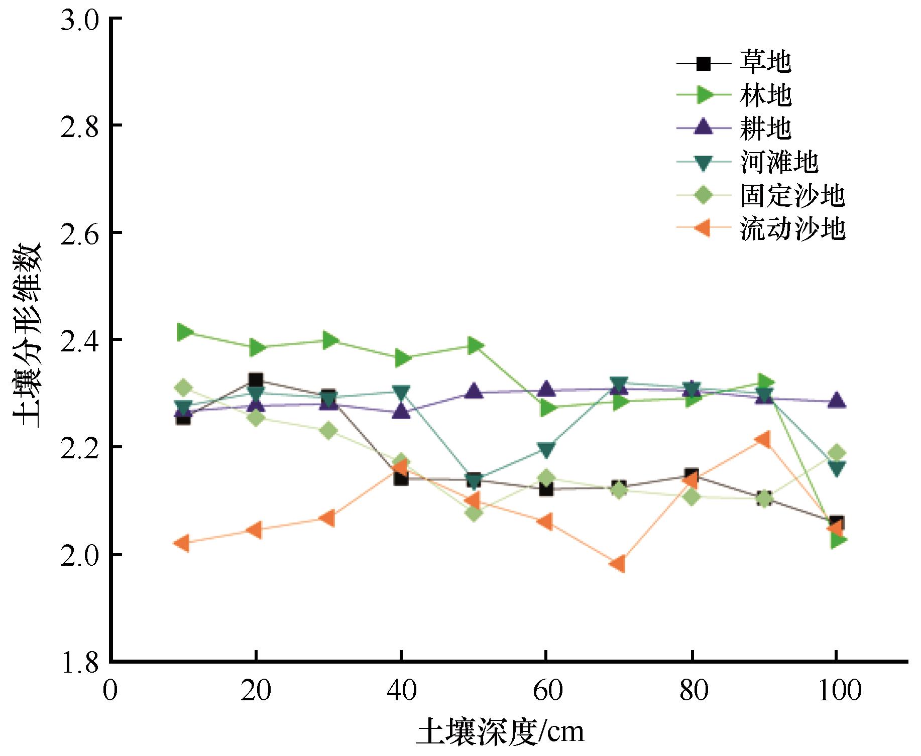
图3 6种下垫面的土壤单重分形维数
Fig.3 Soil single fractal dimension for six underlying surfaces
| 下垫面类型 | 土层深度/cm | 土壤有机质/(g·kg-1) | 速效钾/(mg·kg-1) | 全钾/(g·kg-1) | 全氮/(g·kg-1) | 全磷/(g·kg-1) | 速效磷/(mg·kg-1) | 水溶盐/(g·kg-1) |
|---|---|---|---|---|---|---|---|---|
| 草地 | 0~20 | 8.95±0.7b | 50.8±6.14a | 20.06±0.8a | 0.05±0.01b | 0.68±0.11ab | 2.42±0.62b | 0.3±0.1a |
| 20~40 | 6.28±0.65b | 48±4.95a | 19.52±0.92a | 0.05±0.01b | 0.62±0.1b | 2.11±0.29b | 0.3±0.1a | |
| 40~60 | 4.72±0.76b | 44.4±4.16a | 18.9±0.96a | 0.04±0bc | 0.59±0.1ab | 1.87±0.2b | 0.28±0.08a | |
| 60~80 | 3.33±0.66b | 42.8±4.66a | 18.32±1.01a | 0.03±0a | 0.53±0.09ab | 1.73±0.15ab | 0.24±0.09a | |
| 80~100 | 2.19±0.53bc | 40.4±3.58a | 17.64±1.15a | 0.02±0ab | 0.49±0.08ab | 1.6±0.13ab | 0.2±0.1a | |
| 林地 | 0~20 | 15.53±3.54a | 34.13±10.18b | 19.35±1.77a | 0.09±0.01a | 0.65±0.19ab | 5.62±1.88a | 0.24±0.07ab |
| 20~40 | 11.9±3.15a | 32.13±9.49b | 18.81±1.7a | 0.07±0.01a | 0.59±0.13b | 4.29±1.8a | 0.23±0.09ab | |
| 40~60 | 7.79±1.71a | 29±8.45b | 18.3±1.65a | 0.05±0.01ab | 0.55±0.1b | 3.38±1.2a | 0.19±0.08ab | |
| 60~80 | 5.87±1.87a | 26.75±7.61b | 17.65±1.66a | 0.04±0.01a | 0.53±0.1ab | 2.59±0.7a | 0.16±0.07a | |
| 80~100 | 3.89±1.6a | 23.75±6.23c | 17.29±1.61a | 0.03±0.01a | 0.47±0.08b | 1.98±0.46a | 0.15±0.05ab | |
| 耕地 | 0~20 | 13.86±4.74a | 38.5±5.8b | 16.84±5.35a | 0.09±0.02a | 0.82±0.21a | 3.64±2.33ab | 0.23±0.05ab |
| 20~40 | 9.29±3.33a | 36.5±5.07b | 16.43±5.26a | 0.07±0.02a | 0.79±0.17a | 2.68±1.59ab | 0.2±0ab | |
| 40~60 | 7.3±2.16a | 34±5.89b | 15.94±5.34a | 0.05±0.01a | 0.71±0.17a | 2.04±0.89b | 0.2±0ab | |
| 60~80 | 5.6±1.18a | 32.75±4.43b | 15.31±5.05a | 0.04±0.01a | 0.64±0.11a | 1.77±0.66ab | 0.18±0.05a | |
| 80~100 | 2.77±0.6ab | 33.75±3.95b | 14.81±5.13a | 0.03±0.01a | 0.58±0.07a | 1.4±0.47ab | 0.18±0.05ab | |
| 河滩地 | 0~20 | 2.38±0.7c | 13.5±3.54d | 18.45±0.49a | 0.02±0d | 0.56±0.08b | 1.94±0.39b | 0.15±0.07b |
| 20~40 | 1.91±0.16d | 13±2.83c | 18.05±0.49a | 0.01±0d | 0.53±0.07b | 1.43±0.25b | 0.15±0.07b | |
| 40~60 | 1.78±0.1d | 14.5±0.71c | 17.75±0.49a | 0.01±0e | 0.51±0.06b | 1.23±0.23b | 0.15±0.07b | |
| 60~80 | 1.46±0.34c | 12±2.83c | 17.2±0.28a | 0.01±0c | 0.47±0.03b | 1.15±0.14b | 0.15±0.07a | |
| 80~100 | 1.33±0.47c | 11.5±2.12d | 16.75±0.35a | 0.01±0d | 0.45±0.01b | 1.02±0.04b | 0.1±0b | |
| 固定沙地 | 0~20 | 7.06±2.15b | 30.67±6bc | 20.21±2.35a | 0.04±0.02bc | 0.62±0.1ab | 2.81±1.45b | 0.22±0.08ab |
| 20~40 | 5.48±1.29b | 29.33±5.2b | 18.8±1.49a | 0.04±0.02bc | 0.57±0.07b | 2.46±0.98b | 0.22±0.08ab | |
| 40~60 | 3.91±0.9bc | 28.78±5.95b | 18.59±2.04a | 0.03±0.01cd | 0.51±0.07b | 2.15±0.94ab | 0.22±0.08ab | |
| 60~80 | 2.67±0.32bc | 25.33±5.66b | 17.9±2.08a | 0.02±0.01b | 0.49±0.07b | 1.94±0.77ab | 0.19±0.08a | |
| 80~100 | 1.79±0.45bc | 24.22±4.84c | 17.6±2.36a | 0.02±0bc | 0.47±0.05b | 1.74±0.46a | 0.16±0.05ab | |
| 流动沙地 | 0~20 | 3.21±1.18c | 20.8±4.6cd | 20.32±1.75a | 0.03±0.01cd | 0.56±0.03b | 2.34±0.71b | 0.18±0.08ab |
| 20~40 | 2.6±1.13cd | 19.2±4.44c | 19.82±1.6a | 0.02±0.01cd | 0.52±0.03b | 2.15±0.57b | 0.16±0.05b | |
| 40~60 | 2.27±1.01cd | 18±3.81c | 19.12±1.58a | 0.02±0.01de | 0.49±0.05b | 1.89±0.58b | 0.14±0.05b | |
| 60~80 | 1.73±0.82bc | 16.6±2.7c | 18.46±1.55a | 0.02±0.01bc | 0.46±0.04b | 1.65±0.42ab | 0.14±0.09a | |
| 80~100 | 1.17±0.41c | 15±2.83d | 17.8±1.66a | 0.01±0cd | 0.44±0.04b | 1.37±0.36ab | 0.12±0.04ab |
表2 6种下垫面的土壤理化指标
Table 2 Soil physical and chemical indicators for six underlying surfaces
| 下垫面类型 | 土层深度/cm | 土壤有机质/(g·kg-1) | 速效钾/(mg·kg-1) | 全钾/(g·kg-1) | 全氮/(g·kg-1) | 全磷/(g·kg-1) | 速效磷/(mg·kg-1) | 水溶盐/(g·kg-1) |
|---|---|---|---|---|---|---|---|---|
| 草地 | 0~20 | 8.95±0.7b | 50.8±6.14a | 20.06±0.8a | 0.05±0.01b | 0.68±0.11ab | 2.42±0.62b | 0.3±0.1a |
| 20~40 | 6.28±0.65b | 48±4.95a | 19.52±0.92a | 0.05±0.01b | 0.62±0.1b | 2.11±0.29b | 0.3±0.1a | |
| 40~60 | 4.72±0.76b | 44.4±4.16a | 18.9±0.96a | 0.04±0bc | 0.59±0.1ab | 1.87±0.2b | 0.28±0.08a | |
| 60~80 | 3.33±0.66b | 42.8±4.66a | 18.32±1.01a | 0.03±0a | 0.53±0.09ab | 1.73±0.15ab | 0.24±0.09a | |
| 80~100 | 2.19±0.53bc | 40.4±3.58a | 17.64±1.15a | 0.02±0ab | 0.49±0.08ab | 1.6±0.13ab | 0.2±0.1a | |
| 林地 | 0~20 | 15.53±3.54a | 34.13±10.18b | 19.35±1.77a | 0.09±0.01a | 0.65±0.19ab | 5.62±1.88a | 0.24±0.07ab |
| 20~40 | 11.9±3.15a | 32.13±9.49b | 18.81±1.7a | 0.07±0.01a | 0.59±0.13b | 4.29±1.8a | 0.23±0.09ab | |
| 40~60 | 7.79±1.71a | 29±8.45b | 18.3±1.65a | 0.05±0.01ab | 0.55±0.1b | 3.38±1.2a | 0.19±0.08ab | |
| 60~80 | 5.87±1.87a | 26.75±7.61b | 17.65±1.66a | 0.04±0.01a | 0.53±0.1ab | 2.59±0.7a | 0.16±0.07a | |
| 80~100 | 3.89±1.6a | 23.75±6.23c | 17.29±1.61a | 0.03±0.01a | 0.47±0.08b | 1.98±0.46a | 0.15±0.05ab | |
| 耕地 | 0~20 | 13.86±4.74a | 38.5±5.8b | 16.84±5.35a | 0.09±0.02a | 0.82±0.21a | 3.64±2.33ab | 0.23±0.05ab |
| 20~40 | 9.29±3.33a | 36.5±5.07b | 16.43±5.26a | 0.07±0.02a | 0.79±0.17a | 2.68±1.59ab | 0.2±0ab | |
| 40~60 | 7.3±2.16a | 34±5.89b | 15.94±5.34a | 0.05±0.01a | 0.71±0.17a | 2.04±0.89b | 0.2±0ab | |
| 60~80 | 5.6±1.18a | 32.75±4.43b | 15.31±5.05a | 0.04±0.01a | 0.64±0.11a | 1.77±0.66ab | 0.18±0.05a | |
| 80~100 | 2.77±0.6ab | 33.75±3.95b | 14.81±5.13a | 0.03±0.01a | 0.58±0.07a | 1.4±0.47ab | 0.18±0.05ab | |
| 河滩地 | 0~20 | 2.38±0.7c | 13.5±3.54d | 18.45±0.49a | 0.02±0d | 0.56±0.08b | 1.94±0.39b | 0.15±0.07b |
| 20~40 | 1.91±0.16d | 13±2.83c | 18.05±0.49a | 0.01±0d | 0.53±0.07b | 1.43±0.25b | 0.15±0.07b | |
| 40~60 | 1.78±0.1d | 14.5±0.71c | 17.75±0.49a | 0.01±0e | 0.51±0.06b | 1.23±0.23b | 0.15±0.07b | |
| 60~80 | 1.46±0.34c | 12±2.83c | 17.2±0.28a | 0.01±0c | 0.47±0.03b | 1.15±0.14b | 0.15±0.07a | |
| 80~100 | 1.33±0.47c | 11.5±2.12d | 16.75±0.35a | 0.01±0d | 0.45±0.01b | 1.02±0.04b | 0.1±0b | |
| 固定沙地 | 0~20 | 7.06±2.15b | 30.67±6bc | 20.21±2.35a | 0.04±0.02bc | 0.62±0.1ab | 2.81±1.45b | 0.22±0.08ab |
| 20~40 | 5.48±1.29b | 29.33±5.2b | 18.8±1.49a | 0.04±0.02bc | 0.57±0.07b | 2.46±0.98b | 0.22±0.08ab | |
| 40~60 | 3.91±0.9bc | 28.78±5.95b | 18.59±2.04a | 0.03±0.01cd | 0.51±0.07b | 2.15±0.94ab | 0.22±0.08ab | |
| 60~80 | 2.67±0.32bc | 25.33±5.66b | 17.9±2.08a | 0.02±0.01b | 0.49±0.07b | 1.94±0.77ab | 0.19±0.08a | |
| 80~100 | 1.79±0.45bc | 24.22±4.84c | 17.6±2.36a | 0.02±0bc | 0.47±0.05b | 1.74±0.46a | 0.16±0.05ab | |
| 流动沙地 | 0~20 | 3.21±1.18c | 20.8±4.6cd | 20.32±1.75a | 0.03±0.01cd | 0.56±0.03b | 2.34±0.71b | 0.18±0.08ab |
| 20~40 | 2.6±1.13cd | 19.2±4.44c | 19.82±1.6a | 0.02±0.01cd | 0.52±0.03b | 2.15±0.57b | 0.16±0.05b | |
| 40~60 | 2.27±1.01cd | 18±3.81c | 19.12±1.58a | 0.02±0.01de | 0.49±0.05b | 1.89±0.58b | 0.14±0.05b | |
| 60~80 | 1.73±0.82bc | 16.6±2.7c | 18.46±1.55a | 0.02±0.01bc | 0.46±0.04b | 1.65±0.42ab | 0.14±0.09a | |
| 80~100 | 1.17±0.41c | 15±2.83d | 17.8±1.66a | 0.01±0cd | 0.44±0.04b | 1.37±0.36ab | 0.12±0.04ab |
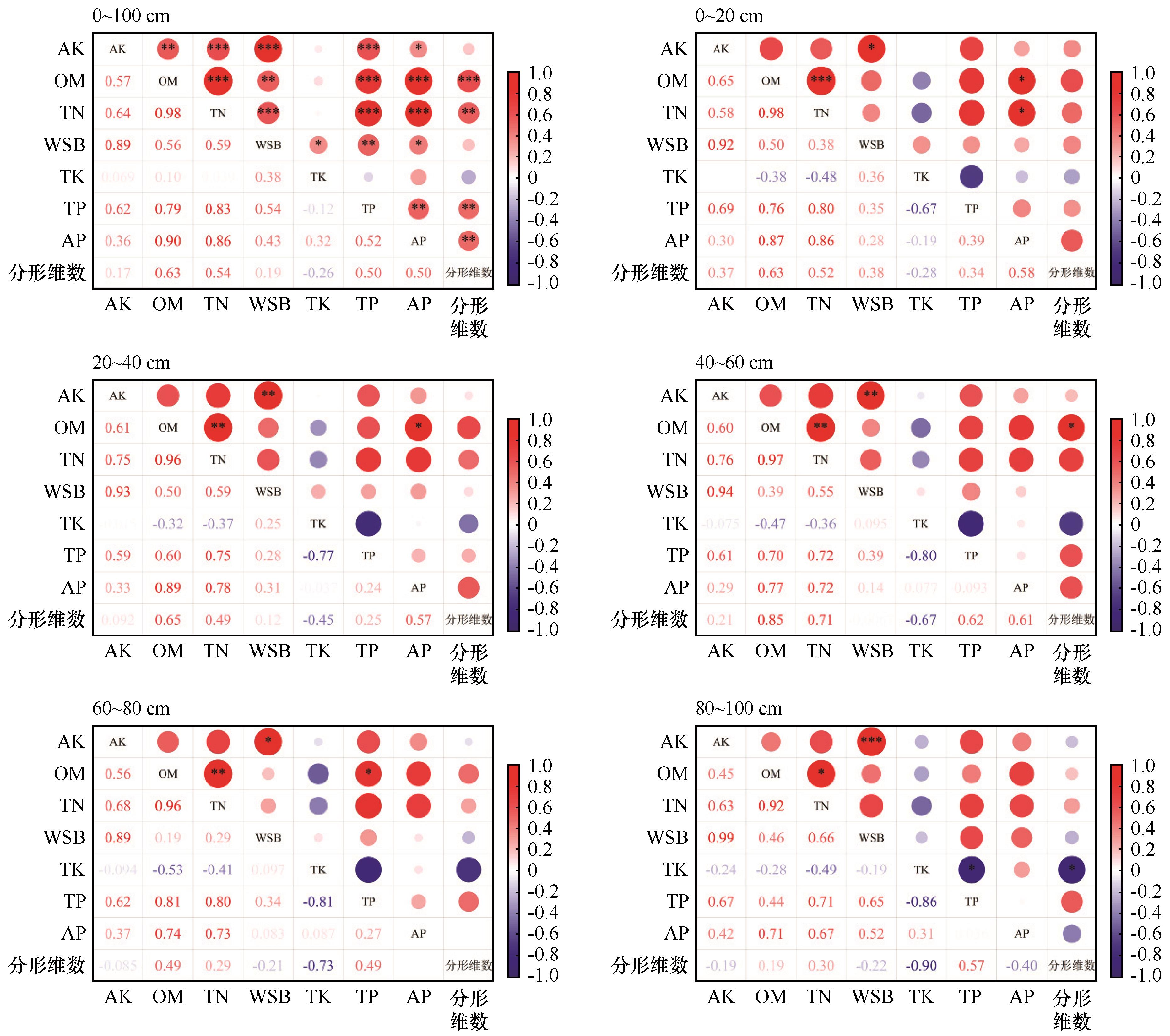
图4 土壤单重分形维数与理化指标的相关性注:*表示显著相关(P < 0.05),**表示极显著相关(P < 0.01),***表示极其显著相关(P < 0.001)。
Fig.4 Correlation between soil single fractal dimension and physical and chemical indicators
| 下垫面类型 | 土壤分形维数 | 土壤有机质/% | 养分胶结比 | 养分综合指数 | 气候修正因子 | 土壤抗风蚀能力指数 |
|---|---|---|---|---|---|---|
| 草地 | 2.290 | 0.895 | 0.015 | 0.696 | 0.915 | 0.955 |
| 林地 | 2.400 | 1.553 | 0.027 | 0.597 | 0.915 | 1.086 |
| 耕地 | 2.272 | 1.386 | 0.014 | 0.575 | 0.915 | 1.012 |
| 河滩地 | 2.289 | 0.238 | 0.005 | 0.165 | 0.915 | 0.711 |
| 固定沙地 | 2.283 | 0.706 | 0.014 | 0.423 | 0.915 | 0.856 |
| 流动沙地 | 2.033 | 0.321 | 0.007 | 0.249 | 0.915 | 0.675 |
表3 6种下垫面土壤抗风蚀能力
Table 3 Wind erosion resistance of 6 underlying soil types
| 下垫面类型 | 土壤分形维数 | 土壤有机质/% | 养分胶结比 | 养分综合指数 | 气候修正因子 | 土壤抗风蚀能力指数 |
|---|---|---|---|---|---|---|
| 草地 | 2.290 | 0.895 | 0.015 | 0.696 | 0.915 | 0.955 |
| 林地 | 2.400 | 1.553 | 0.027 | 0.597 | 0.915 | 1.086 |
| 耕地 | 2.272 | 1.386 | 0.014 | 0.575 | 0.915 | 1.012 |
| 河滩地 | 2.289 | 0.238 | 0.005 | 0.165 | 0.915 | 0.711 |
| 固定沙地 | 2.283 | 0.706 | 0.014 | 0.423 | 0.915 | 0.856 |
| 流动沙地 | 2.033 | 0.321 | 0.007 | 0.249 | 0.915 | 0.675 |
| [1] | Yang J H, Xia D S, Wang S Y,et al.Near-surface wind environment in the Yarlung Zangbo River basin,southern Tibetan Plateau[J].Journal of Arid Land,2020,12(6):917-936. |
| [2] | 董玉祥,李森,董光荣.雅鲁藏布江流域土地沙漠化现状与成因初步研究:兼论人为因素在沙漠化中的作用[J].地理科学,1999,19(1):35-41. |
| [3] | Ling Z Y, Li J S, Jin J H,et al.Geochemical character-istics and provenance of Aeolian sediments in the Yarlung Tsangpo valley,southern Tibetan Plateau[J].Environmental Earth Sciences,2021,80:623. |
| [4] | 刘慧,李晓英,夏翠珍,等.雅鲁藏布江河谷加查-米林段沙丘成因[J].中国沙漠,2020,40(3):16-26. |
| [5] | 孙明,沈渭寿,李海东,等.雅鲁藏布江源区风沙化土地演变趋势[J].自然资源学报,2010,25(7):1163-1171. |
| [6] | Samahadthai P, Vityakon P, Saenjan P.Effects of different quality plant residues on soil carbon accumulation and aggregate formation in a tropical sandy soil in Northeast Thailand as revealed by a 10‐year field experiment[J].Land Degradation & Development,2010,21(5):463-473. |
| [7] | 廖红建,刘少华,何玉琪,等.黄土孔径和持水特性的分形维数研究[J].西北大学学报(自然科学版),2022,52(3):416-422. |
| [8] | 周娜,张春来,刘永刚.雅鲁藏布江米林宽谷段爬升沙丘粒度分异特征研究[J].地理研究,2012,31(1):82-94. |
| [9] | Gao G, Ding G, Zhao Y,et al.Effects of soil particle size classification system on calculating volume-based fractal dimension[J].Journal of Basic Science and Engineering,2014,22(6):1060-1068. |
| [10] | 袁磊,沈渭寿,李海东,等.雅鲁藏布江中游河谷区域风沙化土地演变趋势及驱动因素[J].生态与农村环境学报,2010,26(4):301-305. |
| [11] | Du S S, Wu Y Q, Tan L H,et al.Geochemical charac-teristics of fine and coarse fractions of sediments in the Yarlung Zangbo River Basin(southern Tibet,China)[J].Environmental Earth Sciences,2018,77:337. |
| [12] | 张正偲,董治宝.风沙地貌形态动力学研究进展[J].地球科学进展,2014,29(6):734-747. |
| [13] | 祁迎春,王益权,刘军,等.不同土地利用方式土壤团聚体组成及几种团聚体稳定性指标的比较[J].农业工程学报,2011,27(1):340-347. |
| [14] | Wang Y Y, He Y J, Zhang J,et al.Identification of soil particle size distribution in different sedimentary environments at river basin scale by fractal dimension[J].Scientific Reports,2020,12(1):10960. |
| [15] | 潘美慧,薛雯轩,伍永秋,等.西藏定结地区爬坡沙丘粒度特征分析[J].干旱区地理,2019,42(6):1337-1345. |
| [16] | 李海东,沈渭寿,邹长新,等.雅鲁藏布江山南宽谷风沙化土地土壤养分和粒度特征[J].生态学报,2012,32(16):4981-4992. |
| [17] | 赵萌萌,张根,古明双.基于USLE和GIS对雅鲁藏布江贡嘎段流域水土流失敏感度的评价[J].长江信息通信,2023,36(4):60-62. |
| [18] | 谭杰峻,邓健,范建容,等.雅鲁藏布江中游地区小流域土壤侵蚀分级指标研究[J].中国水土保持,2019,(8):56-59+69. |
| [19] | 王薇,邬光剑,范丽行,等.2000-2020年雅鲁藏布江中部流域大气气溶胶时空变化及影响因素[J].环境科学,2024,45(12):7003-7011. |
| [20] | 张佳瑞,王金满,祝宇成,等.分形理论在土壤学应用中的研究进展[J].土壤通报,2017,48(1):221-228. |
| [21] | Zou X Y, Zhang C L, Cheng H,et al.Cogitation on developing a dynamic model of soil wind erosion[J].Science China Earth Sciences,2015,58(3):337-348. |
| [22] | Liu H, Ding G, Gong H,et al.Wind erodibility of alpine sandy soils in the Yarlung Zangbo River valley:Improved assessment based on the Chepil equation[J].Science of the Total Environment,2025,897:165432. |
| [23] | 王学林,高广磊,丁国栋,等.沙地樟子松人工林土壤酶活性研究[J].干旱区资源与环境,2021,35(1):114-120. |
| [24] | Bateman M D, Bryant R G, Foster I D L,et al.On the formation of sand ramps:A case study from the Mojave Desert[J].Geomorphology,2012,161(1):93-109. |
| [25] | 连玉珍,刘合满,曹丽花,等.西藏林芝不同土地利用方式的土壤团聚体及其有机碳分布[J].浙江农业学报,2019,31(8):1353-1360. |
| [26] | 王晓枝,董治宝,南维鸽,等.拉萨河谷爬坡沙丘沉积物特征[J].中国沙漠,2022,42(4):22-31. |
| [27] | 宛倩,王杰,王向涛,等.青藏高原不同草地利用方式对土壤粒径分形特征的影响[J].生态学报,2022,42(5):1716-1726. |
| [28] | Wang J, Zhao W W, Wang Guan,et al.Effects of long-term afforestation and natural grassland recovery on soil properties and quality in Loess Plateau (China)[J].Science of the Total Environment,2021,770:144833. |
| [29] | Ojekanmii A A, Chang S X.Soil quality assessment for peatmineral mix cover soil used in oil sands reclamation[J].Journal of Environmental Quality,2014,43(5):1566-1575. |
| [30] | 吴启堂.环境土壤学[M].北京:中国农业出版社,2011. |
| [31] | 刘志强,高吉喜,田美荣,等.生态修复区植物群落土壤粒径的分维特征[J].生态学杂志,2017,36(2):303-308. |
| [32] | 李爱敏,韩致文.新月形沙丘形态参数与移动速度的关系[J].中国沙漠,2020,40(1):29-40. |
| [33] | Wei Y J, Wu X L, Xia J W,et al.Variation of soil aggregation along the weathering gradient:comparison of grain size distribution under different disruptive forces[J].PLoS One,2016,11(8):e0160960. |
| [34] | Cheng Y T, Xu G C, Wang X K,et al.Contribution of soil aggregate particle size to organic carbon and the effect of land use on its distribution in a typical small watershed on Loess Plateau,China[J].Ecological Indicators,2023,155,110988. |
| [35] | Yang Z L, Qian G Q, Dong Z B,et al.Migration of barchan dunes and factors that influence migration in the Sanlongsha dune field of the northern Kumtagh Sand Sea,China[J].Geomorphology,2021,378:107615. |
| [36] | Sun K, Wang H, Pei Z Y,et al.Particle-size fractal dimensions and pore structure characteristics of soils of typical vegetation communities in the Kubuqi Desert[J].Frontiers in Environmental Science,2023,10,1044224. |
| [37] | Ruehlmann J, Martin K.Soil particle density as affected by soil texture and soil organic matter:2.predicting the effect of the mineral composition of particle-size fractions[J].Geoderma,2020,375:114543. |
| [38] | Liu Y Y, Gong Y M, Wang X,et al.Volume fractal dimension of soil particles and relationships with soil physical-chemical properties and plant species diversity in an alpine grassland under different disturbance degrees[J].Journal of Arid Land,2013,5(4):480-487. |
| [39] | Wang Z R, Hasi E, Han X J,et al.Fractal characterization of soil particle size distribution under different land use patterns on the north slope of Wula Mountain in China[J].Journal of Soils and Sediments,2024,24(3):1148-1164. |
| [40] | Bai Y F, Qin Y, Lu X R,et al.Fractal dimension of particle-size distribution and their relationships with alkalinity properties of soils in the western Songnen Plain,China[J].Scientific Reports,2020,10(1):20603. |
| [41] | 魏茂宏,林慧龙.江河源区高寒草甸退化序列土壤粒径分布及其分形维数[J].应用生态学报,2014,25(3):679-686. |
| [42] | C.Alfaro Stéphane.Influence of soil texture on the binding energies of fine mineral dust particles potentially released by wind erosion[J].Geomorphology,2008,93(3/4):157-167. |
| [43] | Feng X, Qu J J, Tan L H,et al.Fractal features of sandy soil particle-size distributions during the rangeland desertification process on the eastern Qinghai-Tibet Plateau[J].Journal of Soils and Sediments,2020,20,472-485. |
| [44] | 董苗,严平,王晓旭,等.共和盆地多石在沟爬坡沙丘沉积物特征及环境意义[J].干旱区资源与环境,2022,36(5):79-86. |
| [1] | 吴培浠, 赵媛媛, 陈江波, 阎水明, 丁国栋. 雅鲁藏布江中游地区典型沙地沙尘传输特征[J]. 中国沙漠, 2026, 46(3): 371-380. |
| [2] | 宫航, 刘昊, 陈松焱, 丁国栋. 雅鲁藏布江中下游流域宽谷风蚀区土壤质量[J]. 中国沙漠, 2026, 46(2): 301-311. |
| [3] | 张令光, 沈才生, 黄艳丽, 扎多, 拉珍, 张焱, 张正偲. 雅鲁藏布江流域输沙势空间特征[J]. 中国沙漠, 2025, 45(1): 304-317. |
| [4] | 褚佳琦, 严平, 苏志珠, 袁文杰, 王晓旭, 张潇, 赵华刚. 雅鲁藏布江米林段爬坡沙丘形态演变及移动规律[J]. 中国沙漠, 2024, 44(6): 220-230. |
| [5] | 刘婷, 贾晓鹏, 陈定梅, 益西拉姆, 张炎, 潘凯佳, 张正偲. 雅鲁藏布江中游平坦流沙地表空气动力学特征[J]. 中国沙漠, 2023, 43(5): 194-203. |
| [6] | 拉珍, 唐叔乙, 坚参扎西, 次珍, 马鹏飞. 雅鲁藏布江中游沙尘天气频率及传输过程[J]. 中国沙漠, 2023, 43(4): 10-16. |
| [7] | 黄韵杰, 李永刚, 尹本丰, 张元明. 齿肋赤藓( Syntrichia caninervis )氮磷计量特征对降水量的响应[J]. 中国沙漠, 2023, 43(2): 1-10. |
| [8] | 董苗, 严平, 王晓旭, 张国明, 孟小楠, 纪欣然, 王勇. 雅鲁藏布江山南宽谷段爬坡沙丘表层沉积物特征[J]. 中国沙漠, 2022, 42(2): 153-163. |
| [9] | 落桑曲加, 张焱, 马鹏飞, 扎多, 格多, 张正偲. 雅鲁藏布江中游不同地表输沙量特征[J]. 中国沙漠, 2022, 42(2): 6-13. |
| [10] | 马鹏飞, 论珠群培, 张焱, 次仁尼玛, 逯军峰, 梁爱民, 张正偲. 雅鲁藏布江中游江心洲、河漫滩面积及其指示的沙源特征[J]. 中国沙漠, 2021, 41(3): 25-33. |
| [11] | 张焱, 马鹏飞, 曾林, 梁爱民, 张正偲. 基于沉积物理化性质的雅鲁藏布江中游粉尘物源研究[J]. 中国沙漠, 2021, 41(3): 92-100. |
| [12] | 马鹏飞, 张正偲, 论珠群培, 高佳佳, 戴睿, 次旺, 潘凯佳. 雅鲁藏布江曲水-泽当段风沙活动动力条件分析与风沙灾害防治建议[J]. 中国沙漠, 2021, 41(1): 10-18. |
| [13] | 刘慧, 李晓英, 夏翠珍, 姚正毅. 雅鲁藏布江河谷加查-米林段沙丘成因[J]. 中国沙漠, 2020, 40(3): 16-26. |
| [14] | 刘慧, 李晓英, 姚正毅. 1961-2015年雅鲁藏布江流域降雨侵蚀力[J]. 中国沙漠, 2019, 39(2): 166-176. |
| [15] | 吴海锋, 鹿化煜, 张瀚之, 弋双文, 杨文斌. 雅鲁藏布江中游12 ka BP前后的黄土堆积及其气候意义[J]. 中国沙漠, 2016, 36(3): 616-622. |
| 阅读次数 | ||||||
|
全文 |
|
|||||
|
摘要 |
|
|||||
©2018中国沙漠 编辑部
地址: 兰州市天水中路8号 (730000)
电话:0931-8267545
Email:caiedit@lzb.ac.cn;desert@lzb.ac.cn

 甘公网安备 62010202000688号