
- CN 62-1070/P
- ISSN 1000-694X
- Bimonthly 1981
Journal of Desert Research ›› 2023, Vol. 43 ›› Issue (3): 127-137.DOI: 10.7522/j.issn.1000-694X.2022.00152
Hongyan Zhao1,2( ), Changzhen Yan1(), Sen Li1, Yahui Wang1,2
Received:2022-10-12
Revised:2022-11-28
Online:2023-05-20
Published:2023-05-31
Contact:
Changzhen Yan
CLC Number:
Hongyan Zhao, Changzhen Yan, Sen Li, Yahui Wang. Remote sensing monitoring of aeolian desertification and quantitative analysis of its driving force in the Yellow River Basin during 2000-2020[J]. Journal of Desert Research, 2023, 43(3): 127-137.
Add to citation manager EndNote|Ris|BibTeX
URL: http://www.desert.ac.cn/EN/10.7522/j.issn.1000-694X.2022.00152
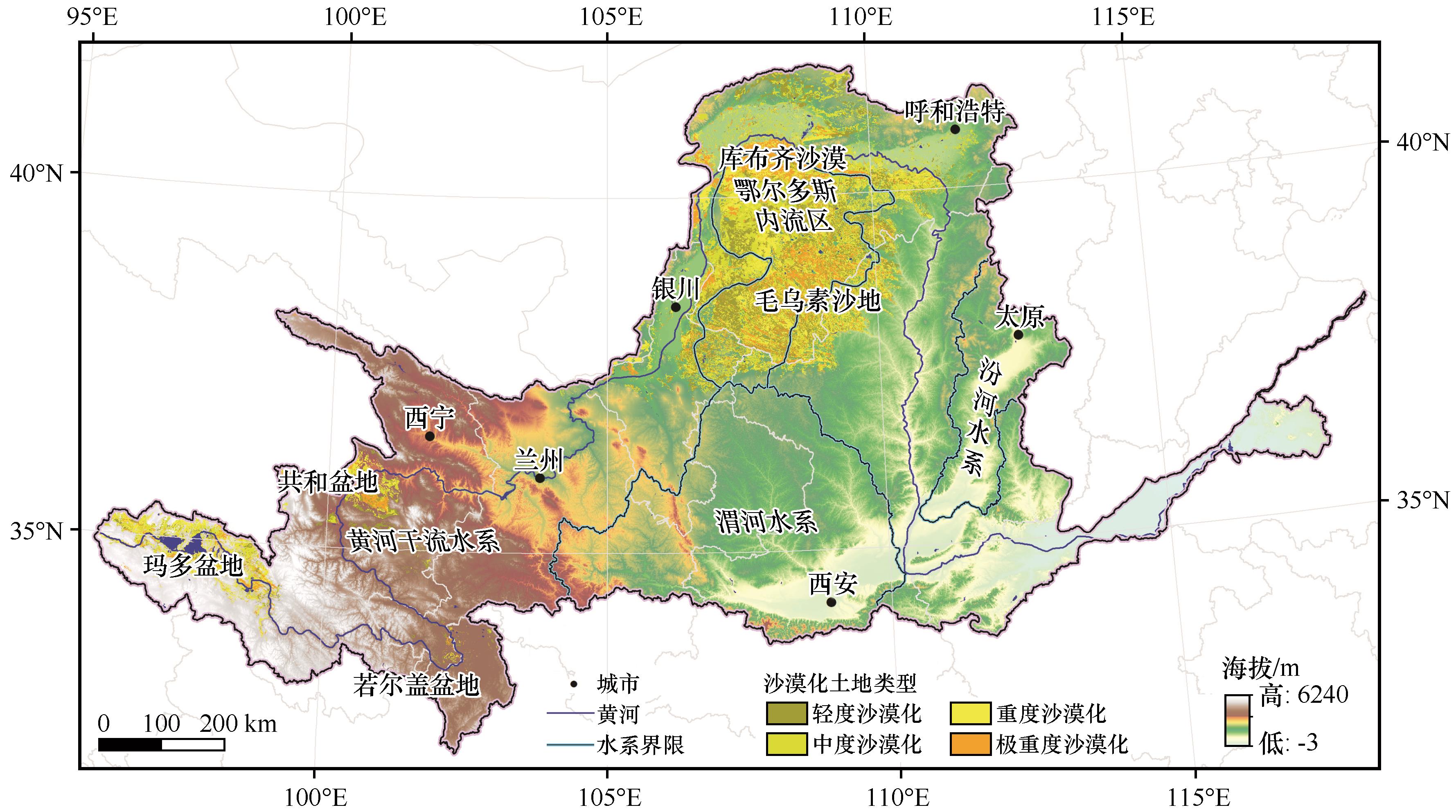
Fig.1 Geographical location of the Yellow River Basin
| 沙漠化土地类型 | 流沙面积比例/% | 植被覆盖度/% | 景观特征 |
|---|---|---|---|
| 轻度沙漠化 | <5 | >60 | 只有零星的流沙斑点,大部分地区原生植被结构未被破坏 |
| 中度沙漠化 | 5~25 | 30~60 | 片状流沙、吹扬灌丛沙堆、风蚀区 |
| 重度沙漠化 | 25~50 | 10~30 | 流沙在区域内的分布面积较大,灌丛沙堆密集,吹扬强烈 |
| 极重度沙漠化 | >50 | <10 | 流动沙丘密集分布,仅有一年生沙生植物 |
Table 1 Classification criterion of aeolian desertification
| 沙漠化土地类型 | 流沙面积比例/% | 植被覆盖度/% | 景观特征 |
|---|---|---|---|
| 轻度沙漠化 | <5 | >60 | 只有零星的流沙斑点,大部分地区原生植被结构未被破坏 |
| 中度沙漠化 | 5~25 | 30~60 | 片状流沙、吹扬灌丛沙堆、风蚀区 |
| 重度沙漠化 | 25~50 | 10~30 | 流沙在区域内的分布面积较大,灌丛沙堆密集,吹扬强烈 |
| 极重度沙漠化 | >50 | <10 | 流动沙丘密集分布,仅有一年生沙生植物 |
| 驱动因素类型 | 不同驱动因素类型划分标准 | 驱动因素相对贡献率 | |||
|---|---|---|---|---|---|
| 气候变化 | 人类活动 | ||||
| 气候变化和人类活动共同驱动 | >0 | >0 | >0 | ||
| <0 | <0 | <0 | |||
| 单独的气候变化驱动 | >0 | >0 | <0 | 100% | 0% |
| <0 | <0 | >0 | |||
| 单独的人类活动驱动 | >0 | <0 | >0 | 0% | 100% |
| <0 | >0 | <0 | |||
Table 2 Identification criterion and contribution rate calculation method of the driving factors[28]
| 驱动因素类型 | 不同驱动因素类型划分标准 | 驱动因素相对贡献率 | |||
|---|---|---|---|---|---|
| 气候变化 | 人类活动 | ||||
| 气候变化和人类活动共同驱动 | >0 | >0 | >0 | ||
| <0 | <0 | <0 | |||
| 单独的气候变化驱动 | >0 | >0 | <0 | 100% | 0% |
| <0 | <0 | >0 | |||
| 单独的人类活动驱动 | >0 | <0 | >0 | 0% | 100% |
| <0 | >0 | <0 | |||
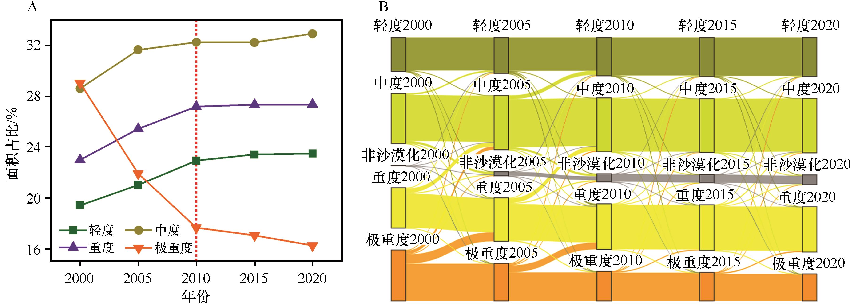
Fig.2 Temporal change (A) and flow direction (B) of different aeolian desertification land types in the Yellow River Basin from 2000 to 2020
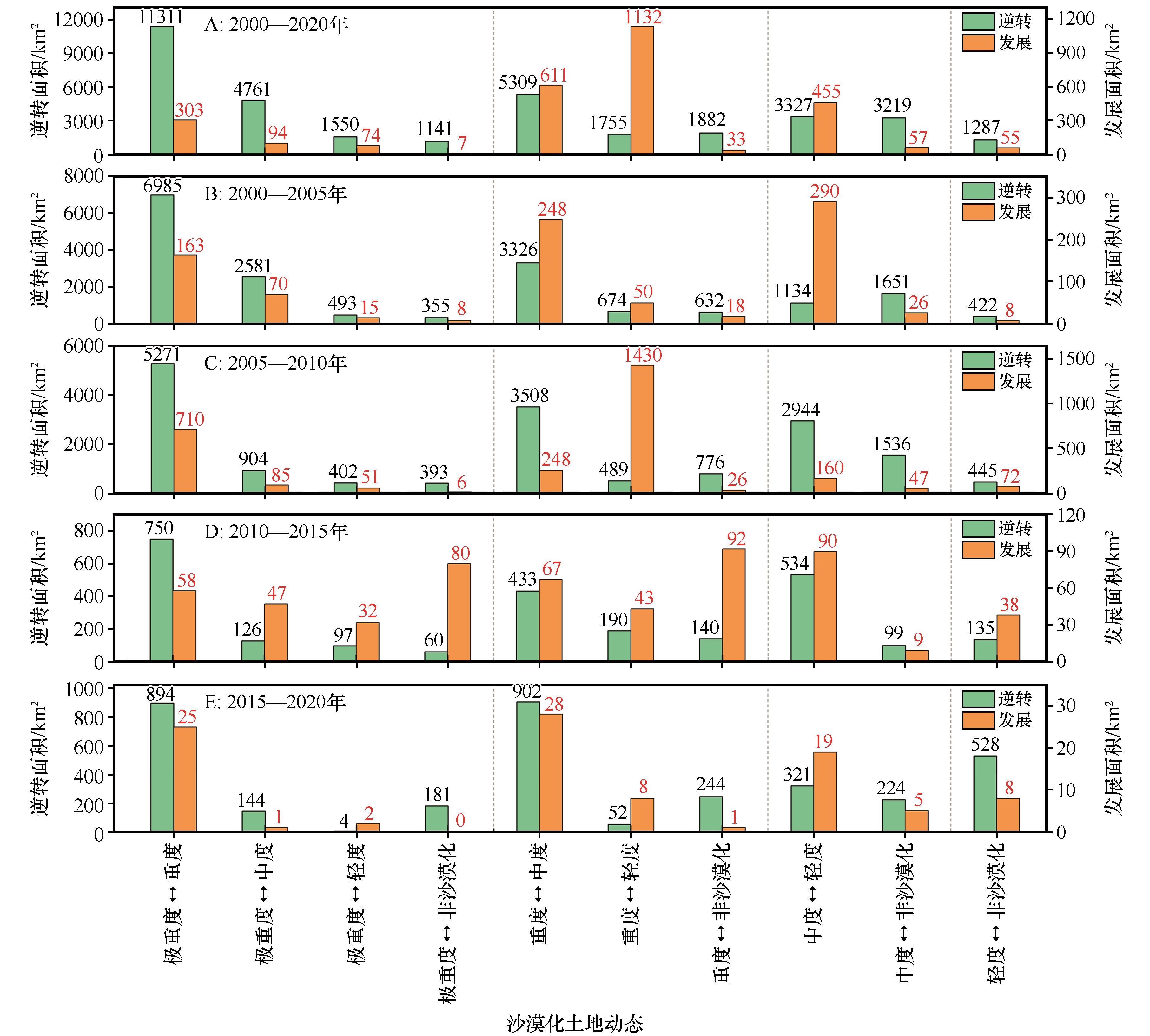
Fig.3 Dynamic change of different aeolian desertification land types in the Yellow River Basin from 2000 to 2020
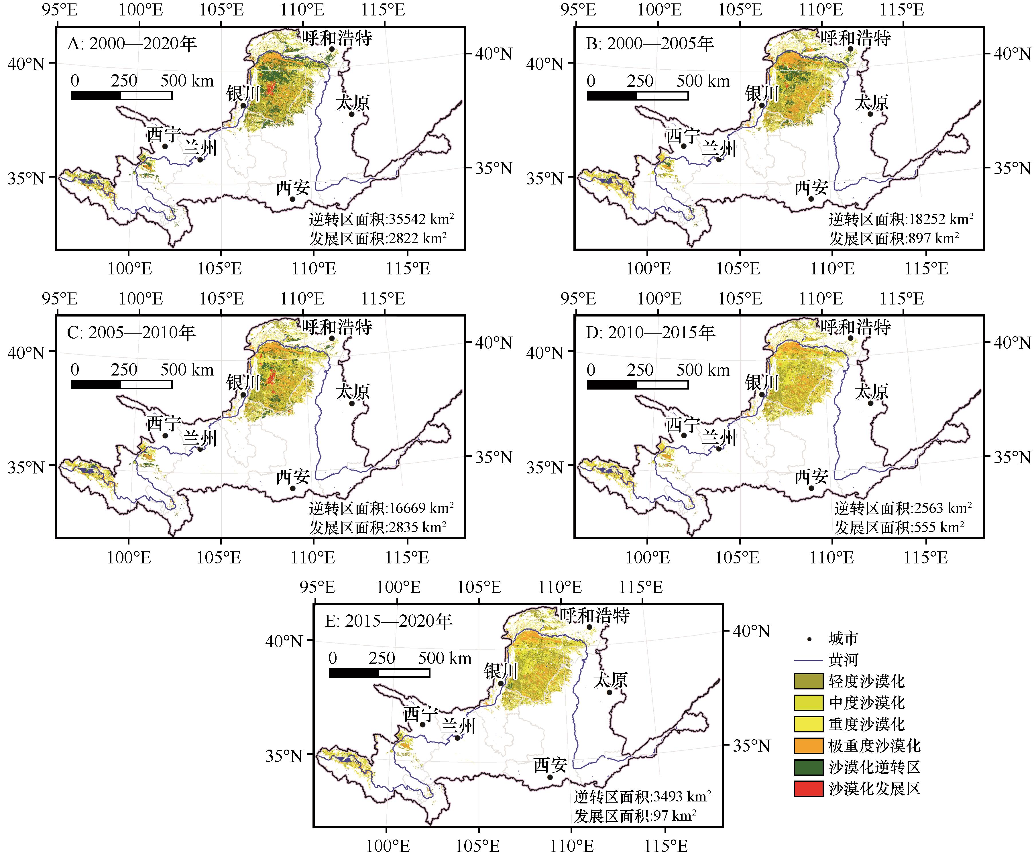
Fig.4 Spatial pattern of different aeolian desertification land types in the Yellow River Basin from 2000 to 2020
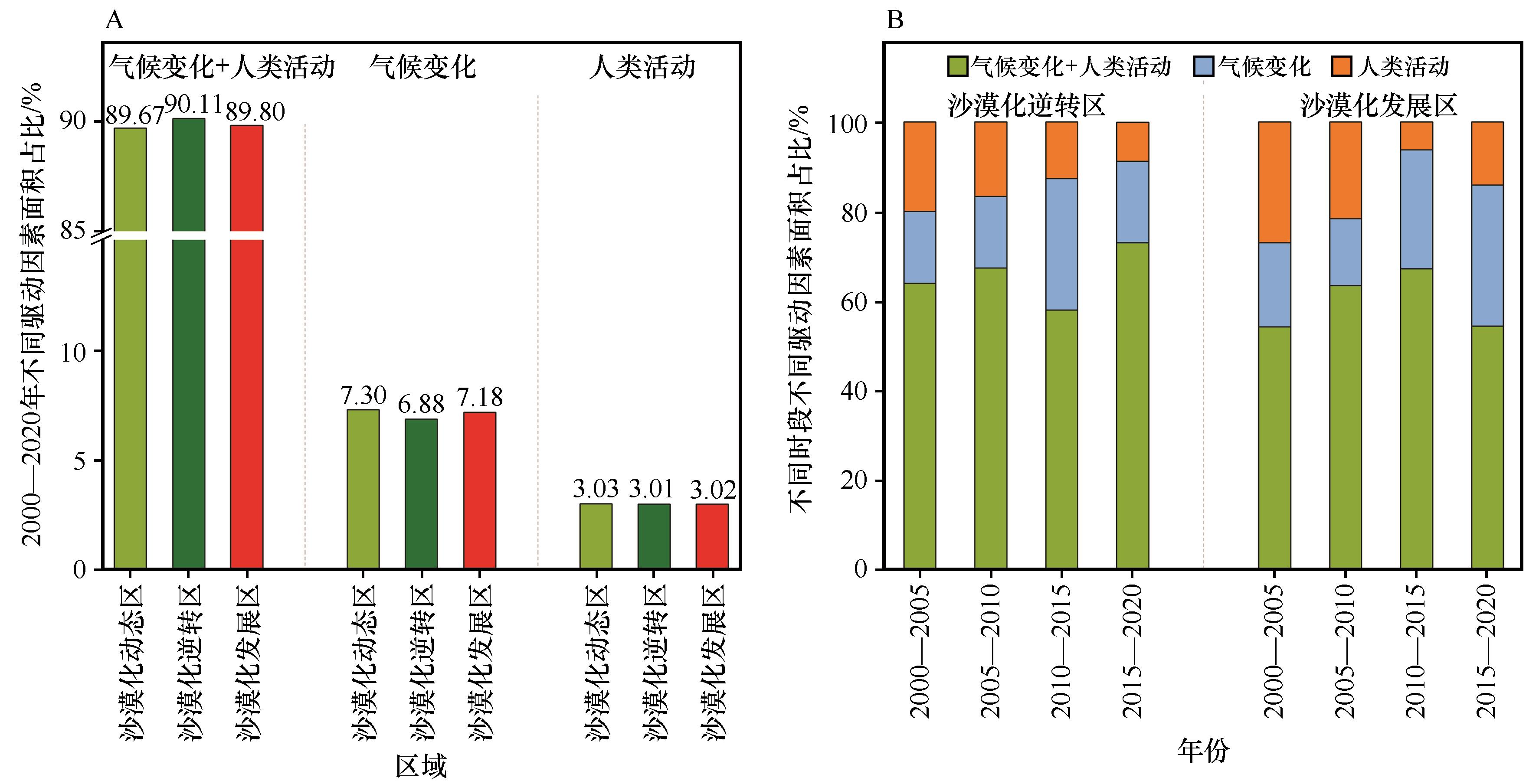
Fig.5 Area proportion (A) and its change (B) of different driving factors in the Yellow River Basin from 2000 to 2020
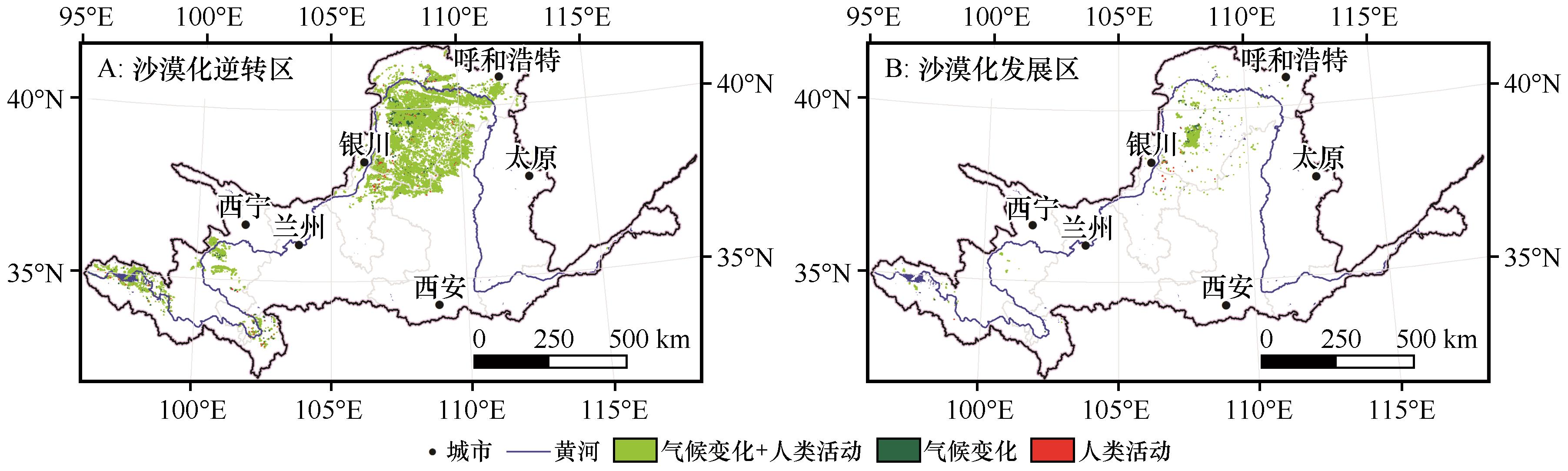
Fig.6 Spatial distribution of different driving factors in aeolian desertification reversal area (A) and aeolian desertification development area (B) in the Yellow River Basin from 2000 to 2020
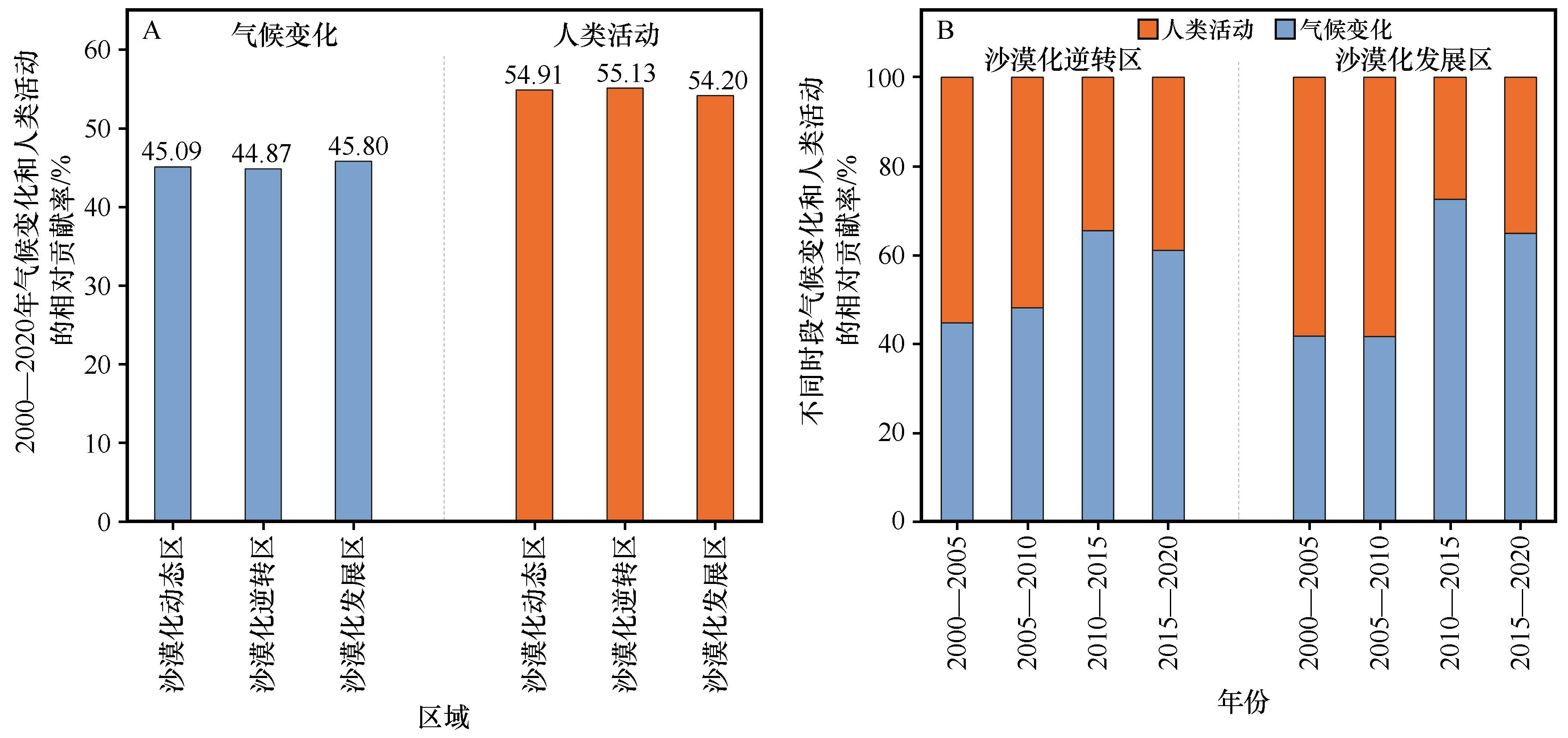
Fig.7 Relative contribution (A) and its change (B) of climate change and human activities in the Yellow River Basin from 2000 to 2020
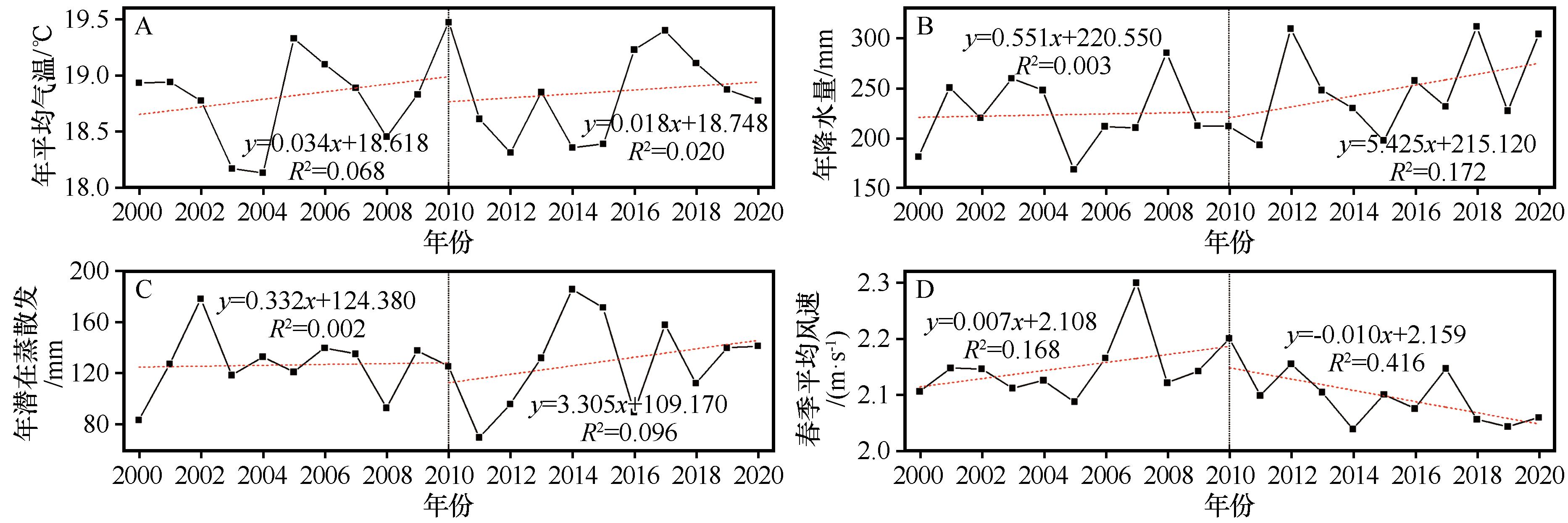
Fig.8 Variation of annual mean temperature (A), annual precipitation (B), annual average potential evapotranspiration (C) and spring average wind speed (D) in the Yellow River Basin from 2000 to 2020
| 1 | Guo B, Wei C, Yu Y,et al.The dominant influencing factors of desertification changes in the source region of Yellow River:climate change or human activity?[J].Science of the Total Environment,2022,813:152512. |
| 2 | Cheng L, Lu Q, Wu B,et al.Estimation of the costs of desertification in China:a critical review[J].Land Degradation & Development,2018,29(4):975-983. |
| 3 | 卢琦,雷加强,李晓松,等.大国治沙:中国方案与全球范式[J].中国科学院院刊,2020,35(6):656-664. |
| 4 | Meng X, Gao X, Li S,et al.Monitoring desertification in Mongolia based on Landsat images and Google Earth Engine from 1990 to 2020[J].Ecological Indicators,2021,129:107908. |
| 5 | 段娟.中国特色荒漠化防治道路的探索历程与经验启示[J].中国井冈山干部学院学报,2021,14(6):74-84. |
| 6 | 屠志方,李梦先,孙涛.第五次全国荒漠化和沙化监测结果及分析[J].林业资源管理,2016(1):1-5. |
| 7 | 范泽孟,李赛博.中蒙俄经济走廊荒漠化时空格局变化及其驱动因子[J].生态学报,2020,40(13):4252-4263. |
| 8 | 肖风劲,徐雨晴,黄大鹏,等.气候变化对黄河流域生态安全影响及适应对策[J].人民黄河,2021,43(1):10-14. |
| 9 | 黄建平,张国龙,于海鹏,等.黄河流域近40年气候变化的时空特征[J].水利学报,2020,51(9):1048-1058. |
| 10 | Han X, Jia G, Yang G,et al.Spatiotemporal dynamic evolution and driving factors of desertification in the Mu Us Sandy Land in 30 years[J].Scientific Reports,2020,10(1):21734. |
| 11 | Xu Z, Hu R, Wang K,et al.Recent greening (1981-2013) in the Mu Us dune field,north-central China,and its potential causes[J].Land Degradation & Development,2018,29(5):1509-1520. |
| 12 | Li S, Wang T, Yan C.Assessing the role of policies on land-use/cover change from 1965 to 2015 in the Mu Us Sandy Land,Northern China[J].Sustainability,2017,9(7):1164. |
| 13 | Qi Y, Chang Q, Jia K,et al.Temporal-spatial variability of desertification in an agro-pastoral transitional zone of northern Shaanxi Province,China[J].Catena,2012,88(1):37-45. |
| 14 | Guo Q, Fu B, Shi P,et al.Satellite monitoring the spatial-temporal dynamics of desertification in response to climate change and human activities across the Ordos Plateau,China[J].Remote Sensing,2017,9(6):525. |
| 15 | 樊奇.中国共产党建党百年来“山水林田湖草沙”系统治理思想的发展逻辑和启示[J].鄱阳湖学刊,2021(2):5-17. |
| 16 | You Y, Zhou N, Wang Y.Comparative study of desertification control policies and regulations in representative countries of the Belt and Road Initiative[J].Global Ecology and Conservation,2021,27:e01577. |
| 17 | 征少卿,张昊渤,许传博,等.碳中和背景下基于TODIM方法的光伏治沙项目选址决策研究[J].项目管理技术,2021,19(11):40-45. |
| 18 | Liu S, Shao Q, Ning J,et al.Remote-sensing-based assessment of the ecological restoration degree and restoration potential of ecosystems in the Upper Yellow River over the past 20 years[J].Remote Sensing,2022,14(15):3550. |
| 19 | Chen H, Sun J.Anthropogenic influence has increased climate extreme occurrence over China[J].Science Bulletin,2021,66(8):749-752. |
| 20 | 孙迎涛,岳艳鹏,成龙,等.毛乌素沙地油蒿(Artemisia ordosica)生长及生物量分配对沙漠化的响应[J].中国沙漠,2022,42(1):123-133. |
| 21 | Feng X, Fu B, Piao S,et al.Revegetation in China's Loess Plateau is approaching sustainable water resource limits[J].Nature Climate Change,2016,6(11):1019-1022. |
| 22 | 胡光印,董治宝,逯军峰,等.黄河流域沙漠化空间格局与成因[J].中国沙漠,2021,41(4):213-224. |
| 23 | Qin G, Meng Z, Fu Y.Drought and water-use efficiency are dominant environmental factors affecting greenness in the Yellow River Basin,China[J].Science of the Total Environment,2022,834:155479. |
| 24 | 董锁成,厉静文,李宇,等.黄河流域荒漠化协同防治与上、中、下游绿色发展[J].环境与可持续发展,2021(2):44-49. |
| 25 | Du H, Xue X, Wang T.Estimation of the quantity of aeolian saltation sediments blown into the Yellow River from the Ulanbuh Desert,China[J].Journal of Arid Land,2013,6(2):205-218. |
| 26 | Tian S, Yu G, Jiang E,et al.Reevaluation of the aeolian sand flux from the Ulan Buh Desert into the upper Yellow River based on in situ monitoring[J].Geomorphology,2019,327:307-318. |
| 27 | Yan C, Wang T, Song X,et al.Temporal and spatial changes in the pattern of sandy desert and sandy land in northern China from 1975 to 2010 based on an analysis of Landsat images[J].International Journal of Remote Sensing,2017,38(12):3551-3563. |
| 28 | 金凯,王飞,韩剑桥,等.1982-2015年中国气候变化和人类活动对植被NDVI变化的影响[J].地理学报,2020,75(5):961-974. |
| 29 | 冯坤,颜长珍,谢家丽,等.1975-2015年鄂尔多斯市沙漠化的时空演变过程[J].中国沙漠,2018,38(2):233-242. |
| 30 | Han J, Wang J, Chen L,et al.Driving factors of desertification in Qaidam Basin,China:an 18-year analysis using the geographic detector model[J].Ecological Indicators,2021,124:107404. |
| 31 | Becerril-Piña R, Mastachi-Loza C, González-Sosa E,et al.Assessing desertification risk in the semi-arid highlands of central Mexico[J].Journal of Arid Environments,2015,120:4-13. |
| 32 | Zhang J, Niu J, Buyantuev A,et al.A multilevel analysis of effects of land use policy on land-cover change and local land use decisions[J].Journal of Arid Environments,2014,108:19-28. |
| 33 | 胡菲,张克存,安志山.敦煌沙漠、绿洲和戈壁地表风动力环境特征同步对比[J].中国沙漠,2020,40(4):113-119. |
| 34 | 田庆久,闵祥军.植被指数研究进展[J].地球科学进展,1998,13(4):10-16. |
| 35 | Zeng Y, Hao D, Huete A,et al.Optical vegetation indices for monitoring terrestrial ecosystems globally[J].Nature Reviews Earth & Environment,2022,3(7):477-493. |
| 36 | 康雄,曹俊涛,陈成,等.不同趋势法的宁夏长时序植被变化分析[J].测绘通报,2020(11):23-27. |
| 37 | Duan H, Wang T, Xue X,et al.Dynamics of aeolian desertification and its driving forces in the Horqin Sandy Land,Northern China[J].Environmental Monitoring and Assessment,2014,186(10):6083-6096. |
| 38 | Na R, Du H, Na L,et al.Spatiotemporal changes in the aeolian desertification of Hulunbuir Grassland and its driving factors in China during 1980-2015[J].Catena,2019,182:104123. |
| 39 | Wang H, Yao F, Zhu H,et al.Spatiotemporal variation of vegetation coverage and its response to climate factors and human activities in arid and semi-arid areas:case study of the Otindag Sandy Land in China[J].Sustainability,2020,12(12):5214. |
| 40 | Liu Q, Zhang Q, Yan Y,et al.Ecological restoration is the dominant driver of the recent reversal of desertification in the Mu Us Desert (China)[J].Journal of Cleaner Production,2020,268:122241. |
| 41 | 李红玉,王京.荒漠化治理的问题与对策:以内蒙古锡林郭勒盟荒漠化治理为例[J].山东财政学院学报,2014(1):86-92. |
| 42 | 邵明安,贾小旭,王云强,等.黄土高原土壤干层研究进展与展望[J].地球科学进展,2016,31(1):14-22. |
| 43 | 周颖,杨秀春,徐斌,等.我国防沙治沙政策的演进历程与特征研究[J].干旱区资源与环境,2020,34(1):123-131. |
| 44 | 石辉,刘秀花,陈占飞,等.陕北榆林毛乌素沙地大规模土地整治开发的生态环境问题及其对策[J].生态学杂志,2019,38(7):2228-2235. |
| 45 | 王有恒,谭丹,韩兰英,等.黄河流域气候变化研究综述[J].中国沙漠,2021,41(4):235-246. |
| 46 | 苗书玲,曹艳萍,李晴晴.1951-2019年黄河流域极端气候事件时空变化规律分析[J].河南大学学报(自然科学版),2022,52(4):416-429. |
| 47 | Li X, Zhang Z, Tan H,et al.Ecological restoration and recovery in the wind-blown sand hazard areas of northern China:relationship between soil water and carrying capacity for vegetation in the Tengger Desert[J].Science China(Life Sciences),2014,57(5):539-548. |
| 48 | 岳艳鹏,孙迎涛,庞营军,等.毛乌素沙地沙丘活化过程中油蒿(Artemisia ordosica)根系特征[J].中国沙漠,2020,40(3):177-184. |
| Viewed | ||||||
|
Full text |
|
|||||
|
Abstract |
|
|||||
©2018Journal of Desert Research
Tel:0931-8267545
Email:caiedit@lzb.ac.cn;desert@lzb.ac.cn
Support:Magtech