
- CN 62-1070/P
- ISSN 1000-694X
- Bimonthly 1981
Journal of Desert Research ›› 2022, Vol. 42 ›› Issue (6): 103-115.DOI: 10.7522/j.issn.1000-694X.2022.00054
Yushuo Zhang1( ), Xuerui Shen1, Renjing Sui1, Jie Bao2, Zhonglei Yu3, Lin Zhao4, Xuebin Zhang5
Received:2022-04-06
Revised:2022-05-05
Online:2022-11-20
Published:2023-01-09
CLC Number:
Yushuo Zhang, Xuerui Shen, Renjing Sui, Jie Bao, Zhonglei Yu, Lin Zhao, Xuebin Zhang. Multi-scale analysis of spatial pattern and the influencing factors of A-grade scenic spots in the Yellow River Basin[J]. Journal of Desert Research, 2022, 42(6): 103-115.
Add to citation manager EndNote|Ris|BibTeX
URL: http://www.desert.ac.cn/EN/10.7522/j.issn.1000-694X.2022.00054
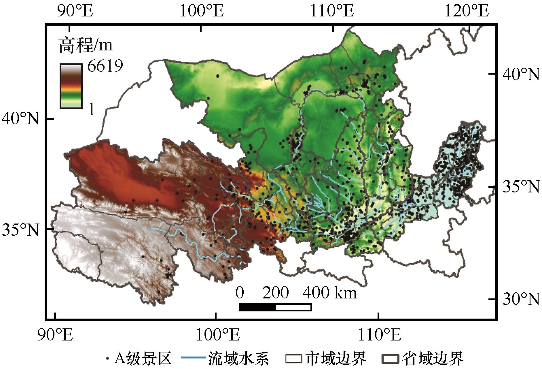
Fig.1 Location of the Yellow River Basin and spatial distribution of A-grade scenic spots
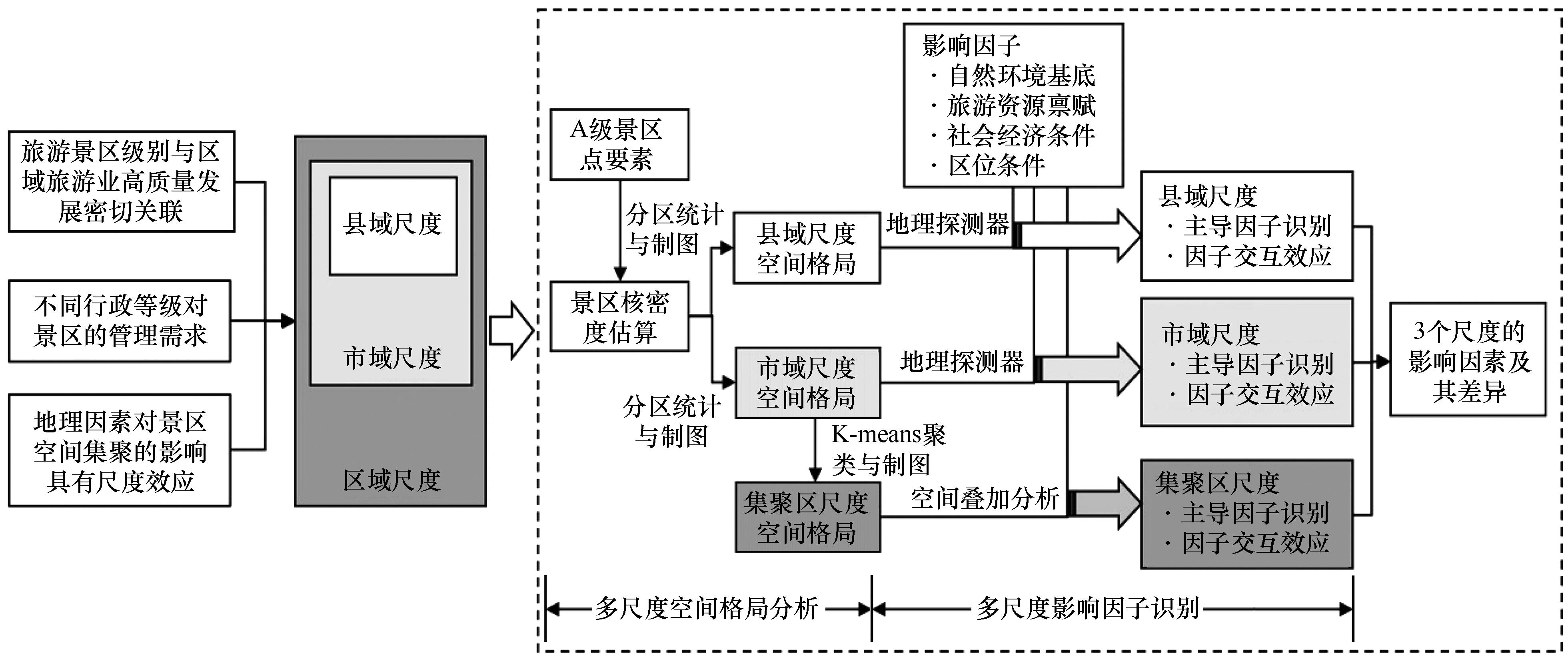
Fig.2 Multi-scale analysis framework of influencing factors of spatial pattern of the A-grade scenic spots
| 因子维度 | 因子指标 | 单位 | 因子符号 | 数据来源及计算方法 |
|---|---|---|---|---|
| 自然环境 基底 | 高程 | m | DEM | SRTM3的DEM数据 |
| 坡度 | ° | Slope | DEM数据的二次曲面拟合 | |
| 年降水量 | mm | PRE | 中国气象科学数据共享服务网 | |
| 植被覆盖度 | — | NDVI | MODIS13Q1产品的NDVI数据 | |
| 到最近河流距离 | km | River | 河流矢量数据的核密度估算 | |
| 旅游资源 禀赋 | 国家级森林公园密度 | — | Park | 国家级森林公园点的核密度估算 |
| 全国重点文物保护单位密度 | — | Heritage | 全国重点文物保护单位点的核密度估算 | |
| 中国传统村落密度 | — | Village | 中国传统村落点的核密度估算 | |
| 国家级非物质文化遗产密度 | — | Cul_Her | 国家级非物质文化遗产点的核密度估算 | |
| 国家湿地公园密度 | — | Wetland | 国家湿地公园点的核密度估算 | |
| 国家地质公园密度 | — | Geopark | 国家地质公园点的核密度估算 | |
| 国家级自然保护区密度 | — | Nat_reser | 国家级自然保护区点的核密度估算 | |
| 社会经济 条件 | 人口密度 | 万人·km-2 | POP | 国家地球系统科学数据中心1 km格网数据 |
| 人均GDP | 元·人-1 | PERGDP | 中国城市统计年鉴、各省的省级统计年鉴、部分县域统计年鉴、统计公报和政府工作报告 | |
| 第三产业占比 | % | Industry | 中国城市统计年鉴,各县国民经济和社会发展统计公报 | |
| 城镇化率 | % | Urban | 中国城市统计年鉴 | |
| 区位 条件 | 到最近铁路距离 | km | Railway | 铁路矢量数据的邻域分析 |
| 到最近公路距离 | km | Road | 公路矢量数据的邻域分析 | |
| 到最近市级行政中心距离 | km | City | 城市驻地矢量数据的邻域分析 | |
| 到最近县级行政中心距离 | km | 到最近县级行政中心距离 | 县城驻地矢量数据的邻域分析 |
Table 1 Details of potential explaining variables for the A-grade scenic spots in the Yellow River Basin
| 因子维度 | 因子指标 | 单位 | 因子符号 | 数据来源及计算方法 |
|---|---|---|---|---|
| 自然环境 基底 | 高程 | m | DEM | SRTM3的DEM数据 |
| 坡度 | ° | Slope | DEM数据的二次曲面拟合 | |
| 年降水量 | mm | PRE | 中国气象科学数据共享服务网 | |
| 植被覆盖度 | — | NDVI | MODIS13Q1产品的NDVI数据 | |
| 到最近河流距离 | km | River | 河流矢量数据的核密度估算 | |
| 旅游资源 禀赋 | 国家级森林公园密度 | — | Park | 国家级森林公园点的核密度估算 |
| 全国重点文物保护单位密度 | — | Heritage | 全国重点文物保护单位点的核密度估算 | |
| 中国传统村落密度 | — | Village | 中国传统村落点的核密度估算 | |
| 国家级非物质文化遗产密度 | — | Cul_Her | 国家级非物质文化遗产点的核密度估算 | |
| 国家湿地公园密度 | — | Wetland | 国家湿地公园点的核密度估算 | |
| 国家地质公园密度 | — | Geopark | 国家地质公园点的核密度估算 | |
| 国家级自然保护区密度 | — | Nat_reser | 国家级自然保护区点的核密度估算 | |
| 社会经济 条件 | 人口密度 | 万人·km-2 | POP | 国家地球系统科学数据中心1 km格网数据 |
| 人均GDP | 元·人-1 | PERGDP | 中国城市统计年鉴、各省的省级统计年鉴、部分县域统计年鉴、统计公报和政府工作报告 | |
| 第三产业占比 | % | Industry | 中国城市统计年鉴,各县国民经济和社会发展统计公报 | |
| 城镇化率 | % | Urban | 中国城市统计年鉴 | |
| 区位 条件 | 到最近铁路距离 | km | Railway | 铁路矢量数据的邻域分析 |
| 到最近公路距离 | km | Road | 公路矢量数据的邻域分析 | |
| 到最近市级行政中心距离 | km | City | 城市驻地矢量数据的邻域分析 | |
| 到最近县级行政中心距离 | km | 到最近县级行政中心距离 | 县城驻地矢量数据的邻域分析 |
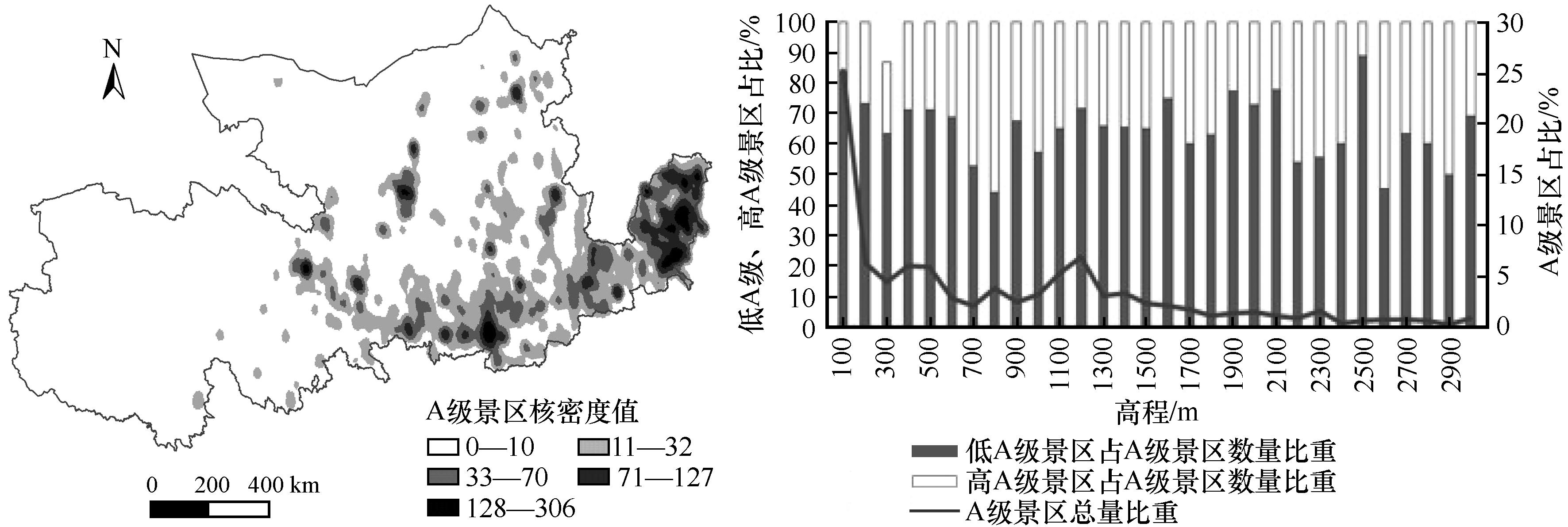
Fig.3 Kernel density and elevation distribution of A-grade scenic spots in the Yellow River Basin
| 景区级别 | 分区数/个 | 总数 /个 | 占比 /% | |||||||
|---|---|---|---|---|---|---|---|---|---|---|
| 青海 | 甘肃 | 宁夏 | 内蒙古 | 陕西 | 山西 | 河南 | 山东 | |||
| AAAAA | 3 | 2 | 4 | 1 | 14 | 7 | 8 | 4 | 43 | 2.44 |
| AAAA | 25 | 48 | 22 | 46 | 77 | 84 | 74 | 90 | 466 | 26.48 |
| AAA | 62 | 93 | 42 | 40 | 225 | 26 | 69 | 307 | 864 | 49.09 |
| AA | 19 | 48 | 25 | 24 | 36 | 20 | 31 | 172 | 377 | 21.42 |
| A | 0 | 0 | 2 | 0 | 1 | 4 | 1 | 4 | 12 | 0.68 |
| 总数/个 | 109 | 191 | 95 | 111 | 353 | 141 | 183 | 577 | 1 760 | 100 |
| 占比/% | 6.19 | 10.85 | 5.40 | 6.31 | 20.06 | 8.01 | 10.40 | 32.78 | 100 | |
Table 2 Number of A-grade scenic spots in provincial-level administrative regions of the Yellow River Basin
| 景区级别 | 分区数/个 | 总数 /个 | 占比 /% | |||||||
|---|---|---|---|---|---|---|---|---|---|---|
| 青海 | 甘肃 | 宁夏 | 内蒙古 | 陕西 | 山西 | 河南 | 山东 | |||
| AAAAA | 3 | 2 | 4 | 1 | 14 | 7 | 8 | 4 | 43 | 2.44 |
| AAAA | 25 | 48 | 22 | 46 | 77 | 84 | 74 | 90 | 466 | 26.48 |
| AAA | 62 | 93 | 42 | 40 | 225 | 26 | 69 | 307 | 864 | 49.09 |
| AA | 19 | 48 | 25 | 24 | 36 | 20 | 31 | 172 | 377 | 21.42 |
| A | 0 | 0 | 2 | 0 | 1 | 4 | 1 | 4 | 12 | 0.68 |
| 总数/个 | 109 | 191 | 95 | 111 | 353 | 141 | 183 | 577 | 1 760 | 100 |
| 占比/% | 6.19 | 10.85 | 5.40 | 6.31 | 20.06 | 8.01 | 10.40 | 32.78 | 100 | |
| 河段 | 主要支流 | 占流域面积 比重/% | 景区数量 /个 | 占景区总数 比重/% | 最近邻 指数(R) | P值 | 空间分布 类型 |
|---|---|---|---|---|---|---|---|
| 上游 | 洮河流域 | 2.08 | 25 | 1.42 | 0.9042 | 0.3597 | 随机型 |
| 湟水流域 | 1.54 | 54 | 3.07 | 0.9923 | 0.9138 | 随机型 | |
| 祖厉河流域 | 0.71 | 2 | 0.11 | 655.461 | 0.0000 | 离散型 | |
| 清水河流域 | 0.93 | 10 | 0.57 | 1.2900 | 0.0794 | 离散型 | |
| 中游 | 大黑河流域 | 0.48 | 25 | 1.42 | 0.9537 | 0.6577 | 随机型 |
| 窟野河流域 | 0.98 | 16 | 0.91 | 0.7352 | 0.0427 | 集聚型 | |
| 无定河流域 | 2.16 | 28 | 1.59 | 0.6761 | 0.0000 | 集聚型 | |
| 汾河流域 | 2.17 | 68 | 3.86 | 0.5506 | 0.0000 | 集聚型 | |
| 渭河流域 | 8.17 | 368 | 20.91 | 0.6131 | 0.0000 | 集聚型 | |
| 下游 | 伊洛河流域 | 1.72 | 70 | 3.98 | 0.7534 | 0.0000 | 集聚型 |
| 沁河流域 | 0.85 | 28 | 1.59 | 0.9372 | 0.525 | 随机型 | |
| 大汶河流域 | 0.74 | 137 | 7.78 | 0.6354 | 0.0000 | 集聚型 |
Table 3 Nearest neighbor index and spatial distribution types of A-grade scenic spots in the main tributaries of the Yellow River Basin
| 河段 | 主要支流 | 占流域面积 比重/% | 景区数量 /个 | 占景区总数 比重/% | 最近邻 指数(R) | P值 | 空间分布 类型 |
|---|---|---|---|---|---|---|---|
| 上游 | 洮河流域 | 2.08 | 25 | 1.42 | 0.9042 | 0.3597 | 随机型 |
| 湟水流域 | 1.54 | 54 | 3.07 | 0.9923 | 0.9138 | 随机型 | |
| 祖厉河流域 | 0.71 | 2 | 0.11 | 655.461 | 0.0000 | 离散型 | |
| 清水河流域 | 0.93 | 10 | 0.57 | 1.2900 | 0.0794 | 离散型 | |
| 中游 | 大黑河流域 | 0.48 | 25 | 1.42 | 0.9537 | 0.6577 | 随机型 |
| 窟野河流域 | 0.98 | 16 | 0.91 | 0.7352 | 0.0427 | 集聚型 | |
| 无定河流域 | 2.16 | 28 | 1.59 | 0.6761 | 0.0000 | 集聚型 | |
| 汾河流域 | 2.17 | 68 | 3.86 | 0.5506 | 0.0000 | 集聚型 | |
| 渭河流域 | 8.17 | 368 | 20.91 | 0.6131 | 0.0000 | 集聚型 | |
| 下游 | 伊洛河流域 | 1.72 | 70 | 3.98 | 0.7534 | 0.0000 | 集聚型 |
| 沁河流域 | 0.85 | 28 | 1.59 | 0.9372 | 0.525 | 随机型 | |
| 大汶河流域 | 0.74 | 137 | 7.78 | 0.6354 | 0.0000 | 集聚型 |
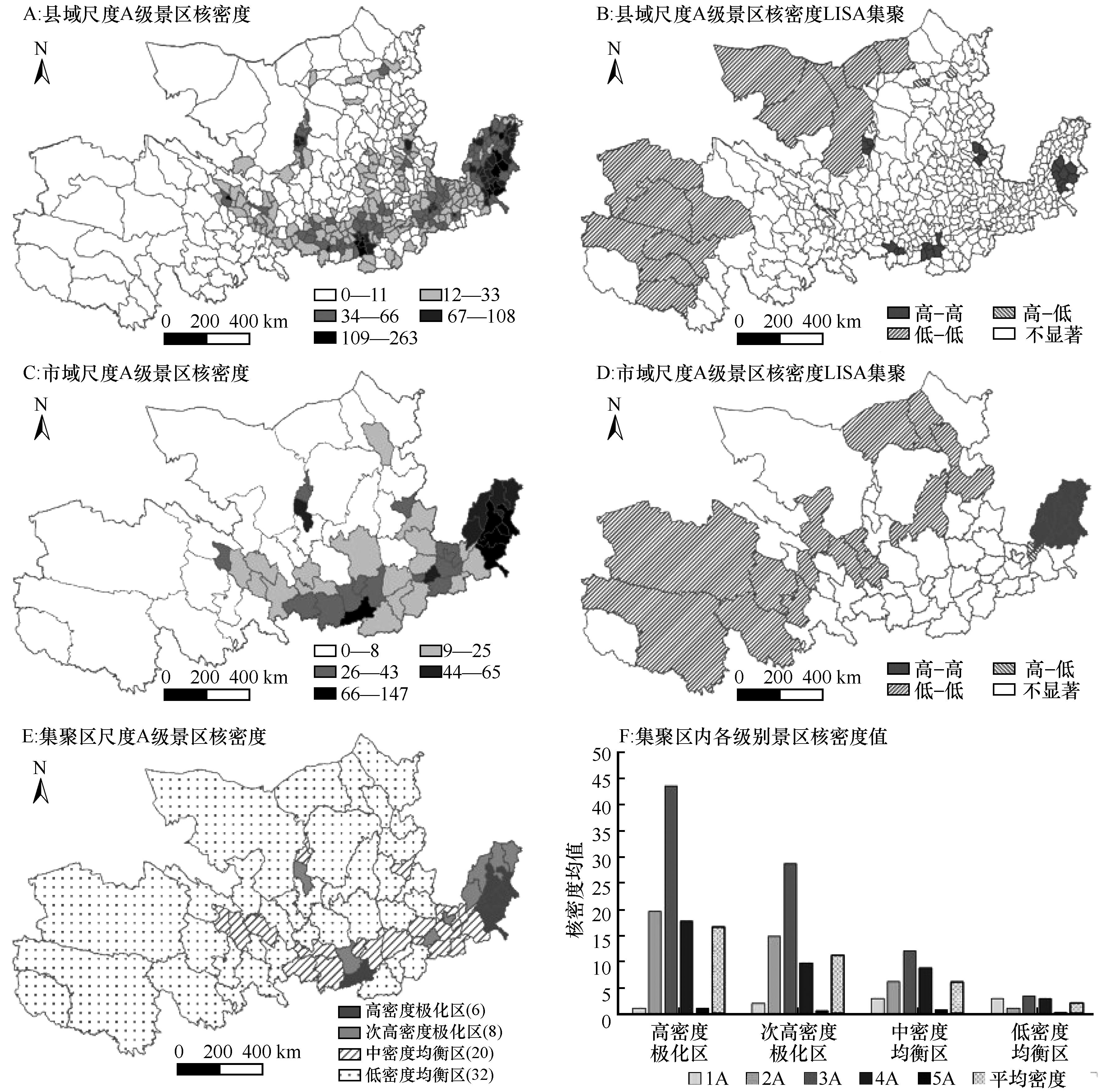
Fig.4 The spatial distribution of A-grade scenic spots at three scales in the Yellow River Basin
| 显著性因子 | 因子符号 | P值 | q值 | 解释力排序 |
|---|---|---|---|---|
| 全国重点文物保护 单位密度 | Heritage | 0.000 | 0.145 | 1 |
| 植被覆盖度 | NDVI | 0.000 | 0.046 | 2 |
| 年降水量 | PRE | 0.000 | 0.045 | 3 |
| 到最近河流距离 | River | 0.005 | 0.037 | 4 |
| 国家湿地公园密度 | Wetland | 0.036 | 0.029 | 5 |
Table 4 Significance influencing factors of the A-grade scenic spots at county scale( P ≤0.05)
| 显著性因子 | 因子符号 | P值 | q值 | 解释力排序 |
|---|---|---|---|---|
| 全国重点文物保护 单位密度 | Heritage | 0.000 | 0.145 | 1 |
| 植被覆盖度 | NDVI | 0.000 | 0.046 | 2 |
| 年降水量 | PRE | 0.000 | 0.045 | 3 |
| 到最近河流距离 | River | 0.005 | 0.037 | 4 |
| 国家湿地公园密度 | Wetland | 0.036 | 0.029 | 5 |
| 交互因子 | q值 | 解释力排序 | 交互因子 | q值 | 解释力排序 |
|---|---|---|---|---|---|
| Heritage ∩ DEM | 0.203 | 3 | NDVI ∩ Road | 0.066 | 18 |
| Heritage ∩ Village | 0.196 | 4 | NDVI ∩ City | 0.078 | 14 |
| Heritage ∩ POP | 0.183 | 6 | PRE ∩ DEM | 0.072 | 17 |
| Heritage ∩ Industry | 0.127 | 9 | PRE ∩ POP | 0.058 | 23 |
| Heritage ∩ PERGDP | 0.195 | 5 | PRE ∩ PERGDP | 0.061 | 22 |
| Heritage ∩ Railway | 0.231 | 2 | PRE ∩ Railway | 0.094 | 10 |
| Heritage ∩ Road | 0.298 | 1 | PRE ∩ Road | 0.092 | 11 |
| Heritage ∩ City | 0.169 | 8 | River ∩ DEM | 0.062 | 20 |
| Heritage ∩ County | 0.178 | 7 | River ∩ Village | 0.078 | 13 |
| NDVI ∩ DEM | 0.077 | 15 | River ∩ Railway | 0.057 | 25 |
| NDVI ∩ POP | 0.058 | 24 | River ∩ Road | 0.061 | 21 |
| NDVI ∩ PERGDP | 0.075 | 16 | Wetland ∩ DEM | 0.065 | 19 |
| NDVI ∩ Railway | 0.085 | 12 | Wetland ∩ POP | 0.037 | 26 |
Table 5 Nonlinear enhancements in the interaction detection of the influencing factors at county scale
| 交互因子 | q值 | 解释力排序 | 交互因子 | q值 | 解释力排序 |
|---|---|---|---|---|---|
| Heritage ∩ DEM | 0.203 | 3 | NDVI ∩ Road | 0.066 | 18 |
| Heritage ∩ Village | 0.196 | 4 | NDVI ∩ City | 0.078 | 14 |
| Heritage ∩ POP | 0.183 | 6 | PRE ∩ DEM | 0.072 | 17 |
| Heritage ∩ Industry | 0.127 | 9 | PRE ∩ POP | 0.058 | 23 |
| Heritage ∩ PERGDP | 0.195 | 5 | PRE ∩ PERGDP | 0.061 | 22 |
| Heritage ∩ Railway | 0.231 | 2 | PRE ∩ Railway | 0.094 | 10 |
| Heritage ∩ Road | 0.298 | 1 | PRE ∩ Road | 0.092 | 11 |
| Heritage ∩ City | 0.169 | 8 | River ∩ DEM | 0.062 | 20 |
| Heritage ∩ County | 0.178 | 7 | River ∩ Village | 0.078 | 13 |
| NDVI ∩ DEM | 0.077 | 15 | River ∩ Railway | 0.057 | 25 |
| NDVI ∩ POP | 0.058 | 24 | River ∩ Road | 0.061 | 21 |
| NDVI ∩ PERGDP | 0.075 | 16 | Wetland ∩ DEM | 0.065 | 19 |
| NDVI ∩ Railway | 0.085 | 12 | Wetland ∩ POP | 0.037 | 26 |
| 显著性因子 | 因子 符号 | P值 | q值 | 解释力 排序 |
|---|---|---|---|---|
| 人口密度 | POP | 0.000 | 0.484 | 1 |
| 高程 | DEM | 0.000 | 0.450 | 2 |
| 到最近市级行政中心距离 | City | 0.000 | 0.416 | 3 |
| 到最近县级行政中心距离 | County | 0.000 | 0.341 | 4 |
| 城镇化率 | Urban | 0.000 | 0.327 | 5 |
| 到最近公路距离 | Road | 0.000 | 0.300 | 6 |
| 到最近铁路距离 | Railway | 0.004 | 0.235 | 7 |
| 全国重点文物保护单位密度 | Heritage | 0.006 | 0.260 | 8 |
| 人均GDP | PERGDP | 0.006 | 0.259 | 9 |
| 年降水量 | PRE | 0.010 | 0.247 | 10 |
| 植被覆盖度 | NDVI | 0.040 | 0.169 | 11 |
Table 6 Significance influencing factors of the A-grade scenic spots at municipal scale( P ≤0.05)
| 显著性因子 | 因子 符号 | P值 | q值 | 解释力 排序 |
|---|---|---|---|---|
| 人口密度 | POP | 0.000 | 0.484 | 1 |
| 高程 | DEM | 0.000 | 0.450 | 2 |
| 到最近市级行政中心距离 | City | 0.000 | 0.416 | 3 |
| 到最近县级行政中心距离 | County | 0.000 | 0.341 | 4 |
| 城镇化率 | Urban | 0.000 | 0.327 | 5 |
| 到最近公路距离 | Road | 0.000 | 0.300 | 6 |
| 到最近铁路距离 | Railway | 0.004 | 0.235 | 7 |
| 全国重点文物保护单位密度 | Heritage | 0.006 | 0.260 | 8 |
| 人均GDP | PERGDP | 0.006 | 0.259 | 9 |
| 年降水量 | PRE | 0.010 | 0.247 | 10 |
| 植被覆盖度 | NDVI | 0.040 | 0.169 | 11 |
| 交互因子 | q值 | 解释力排序 | 交互因子 | q值 | 解释力排序 |
|---|---|---|---|---|---|
| POP ∩ NDVI | 0.675 | 6 | DEM ∩ Village | 0.659 | 8 |
| POP ∩ Park | 0.788 | 2 | City ∩ Park | 0.674 | 7 |
| POP ∩ Heritage | 0.811 | 1 | City ∩ Village | 0.642 | 10 |
| POP ∩ Village | 0.595 | 13 | County ∩ Slope | 0.513 | 14 |
| DEM ∩Slope | 0.694 | 5 | County ∩ Park | 0.633 | 11 |
| DEM ∩ NDVI | 0.696 | 4 | County ∩ PERGDP | 0.652 | 9 |
| DEM ∩ River | 0.616 | 12 | Urban ∩ Slope | 0.492 | 15 |
| DEM ∩ Park | 0.731 | 3 | Urban ∩ Park | 0.353 | 16 |
Table 7 Nonlinear enhancements in the interaction detection of the influencing factors at municipal scale
| 交互因子 | q值 | 解释力排序 | 交互因子 | q值 | 解释力排序 |
|---|---|---|---|---|---|
| POP ∩ NDVI | 0.675 | 6 | DEM ∩ Village | 0.659 | 8 |
| POP ∩ Park | 0.788 | 2 | City ∩ Park | 0.674 | 7 |
| POP ∩ Heritage | 0.811 | 1 | City ∩ Village | 0.642 | 10 |
| POP ∩ Village | 0.595 | 13 | County ∩ Slope | 0.513 | 14 |
| DEM ∩Slope | 0.694 | 5 | County ∩ Park | 0.633 | 11 |
| DEM ∩ NDVI | 0.696 | 4 | County ∩ PERGDP | 0.652 | 9 |
| DEM ∩ River | 0.616 | 12 | Urban ∩ Slope | 0.492 | 15 |
| DEM ∩ Park | 0.731 | 3 | Urban ∩ Park | 0.353 | 16 |
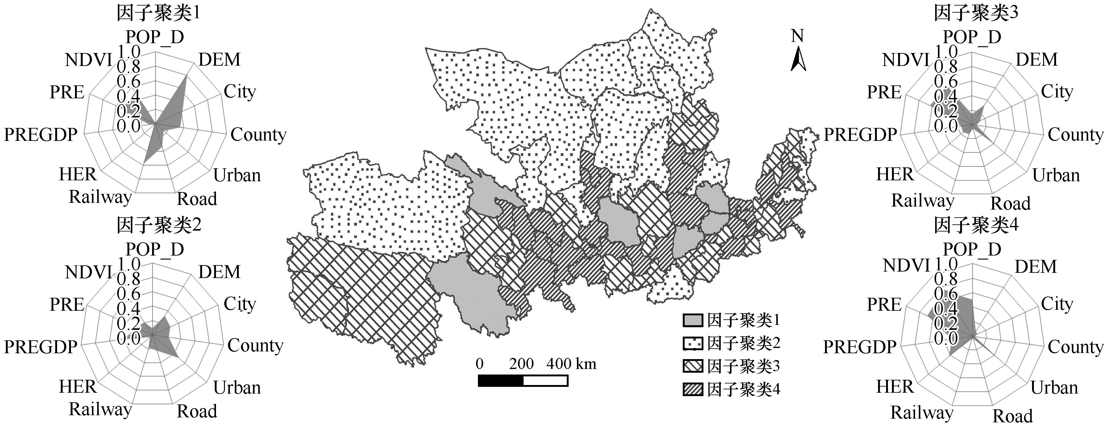
Fig.5 Influencing factors clusters and the spatial distribution of A-grade scenic spots in the Yellow River Basin
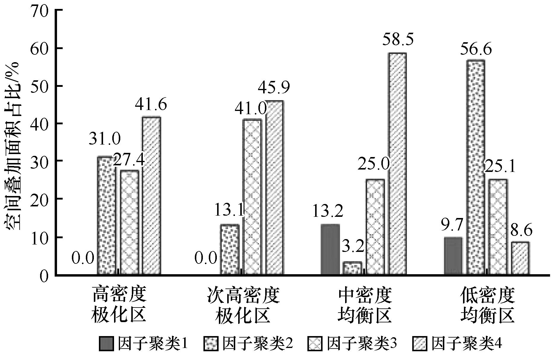
Fig.6 Spatial overlay of the influencing factors clusters and A-grade scenic spot clusters in the Yellow River Basin
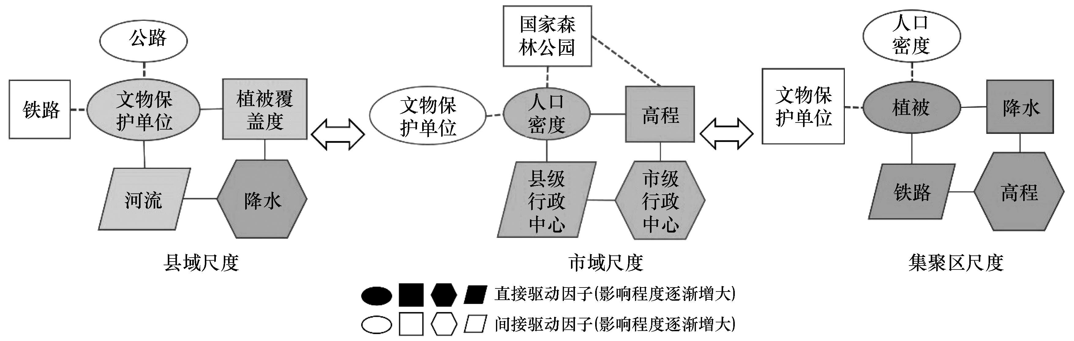
Fig.7 Multi-scale influencing factors of spatial pattern of A-grade scenic spots in the Yellow River Basin
| 1 | 张凌云.旅游景区景点管理[M].北京:旅游教育出版社,2003. |
| 2 | 杨永春,穆焱杰,张薇.黄河流域高质量发展的基本条件与核心策略[J].资源科学,2020,42(3):409-423. |
| 3 | 钟林生.可持续旅游发展历程与未来研究论题探讨[J].旅游学刊,2014,29(3):6-7. |
| 4 | 邹统钎.中国旅游景区管理模式研究[M].天津:南开大学出版社,2006. |
| 5 | 马勇,李玺.旅游规划与开发[M].北京:高等教育出版社,2012. |
| 6 | 李光勤,方徐兵.黄河流域绿色发展水平时空演变特征[J].中国沙漠,2021,41(4):140-150. |
| 7 | 薛明月,王成新,赵金丽,等.黄河流域旅游经济空间分异格局及影响因素[J].经济地理,2020,40(4):21-29. |
| 8 | 穆学青,郭向阳,明庆忠,等.黄河流域旅游生态安全的动态演变特征及驱动因素[J].地理学报,2022,77(3):714-735. |
| 9 | 汪芳,安黎哲,党安荣,等.黄河流域人地耦合与可持续人居环境[J].地理研究,2020,39(8):1707-1724. |
| 10 | 徐勇,王传胜.黄河流域生态保护和高质量发展:框架,路径与对策[J].中国科学院院刊,2020,35(7):875-883. |
| 11 | 郭来喜,吴必虎,刘锋,等.中国旅游资源分类系统与类型评价[J].地理学报,2000,55(3):294-301. |
| 12 | 吴必虎,唐子颖.旅游吸引物空间结构分析:以中国首批国家4A级旅游区(点)为例[J].人文地理,2003,18(1):1-5,28. |
| 13 | 朱竑,陈晓亮.中国A级旅游景区空间分布结构研究[J].地理科学,2008(5):607-615. |
| 14 | 李鹏,虞虎,王英杰.中国3A级以上旅游景区空间集聚特征研究[J].地理科学,2018,38(11):1883-1891. |
| 15 | 潘竟虎,李俊峰.中国A级旅游景点空间分布特征与可达性[J].自然资源学报,2014,29(1):55-66. |
| 16 | 唐承财,孙孟瑶,万紫微.京津冀城市群高等级景区分布特征及影响因素[J].经济地理,2019,39(10):204-213. |
| 17 | 刘敏,郝炜.山西省国家A级旅游景区空间分布影响因素研究[J].地理学报,2020,75(4):878-888. |
| 18 | 宁志中,王婷,杨雪春.2001年以来中国旅游景区时空格局演变与景区群形成[J].地理研究,2020,39(7):1654-1666. |
| 19 | 麻学锋,杨雪.大湘西高级别景区时空分布特征及影响因素的空间异质性[J].自然资源学报,2019,34(9):1902-1916. |
| 20 | 贾垚焱,胡静,刘大均,等.长江中游城市群A级旅游景区空间演化及影响机理[J].经济地理,2019,39(1):198-206. |
| 21 | 李冬花,张晓瑶,陆林,等.黄河流域高级别旅游景区空间分布特征及影响因素[J].经济地理,2020,40(5):73-83. |
| 22 | 吴清,李细归,吴黎.湖南省A级旅游景区分布格局及空间相关性分析[J].经济地理,2017,37(2):193-200. |
| 23 | 刘敏,郝炜,张芙蓉.山西省A级景区空间分布与影响因素[J].经济地理,2020,40(8):233-242. |
| 24 | 袁俊,余瑞林,刘承良.武汉城市圈国家A级旅游景区的空间结构[J].经济地理,2010,30(2):324-328. |
| 25 | 程海峰,胡文海.池州市A级旅游景区空间结构[J].地理科学,2014,34(10):1275-1280. |
| 26 | 傅伯杰.地理学综合研究的途径与方法:格局与过程耦合[J].地理学报,2014,69(8):1052-1059. |
| 27 | 刘云刚,王丰龙.尺度的人文地理内涵与尺度政治:基于1980 年代以来英语圈人文地理学的尺度研究[J].人文地理,2011,3:1-6. |
| 28 | 张宇硕,吴殿廷,吕晓.土地利用/覆盖变化对生态系统服务的影响:空间尺度视角的研究综述[J].自然资源学报,2020,35(5):158-175. |
| 29 | 王萍,刘敏.地理要素在传统无形文化传承中的空间印迹:以山西省非物质文化遗产为例[J].地理研究,2020,39(8):1807-1821. |
| 30 | 李双成,蔡运龙.地理尺度转换若干问题的初步探讨[J].地理研究,2005,24(1):11-18. |
| 31 | 陆林,张清源,许艳,等.全球地方化视角下旅游地尺度重组:以浙江乌镇为例[J].地理学报,2020,75(2):410-425. |
| 32 | 李敏纳,蔡舒,覃成林.黄河流域经济空间分异态势分析[J].经济地理,2011,31(3):379-419. |
| 33 | 张鹏岩,李颜颜,康国华,等.黄河流域县域经济密度测算及空间分异研究[J].中国人口·资源与环境,2017,27(8):128-135. |
| 34 | 倪敬峰,张翀,赵昕.陕西省县域旅游景点空间分异与影响机制研究[J].干旱区资源与环境,2022,36(3):202-208. |
| 35 | Berke O.Exploratory disease mapping:kriging the spatial risk function from regional count data[J].International Journal of Health Geographics,2004,3(1):18. |
| 36 | 周爱武,于亚飞.K-Means聚类算法的研究[J].计算机技术与发展,2011,21(2):62-65. |
| 37 | 王劲峰,徐成东.地理探测器:原理与展望[J].地理学报,2017,72(1):116-134. |
| 38 | 周成,柳炳华,张旭红,等.黄河流域文物保护单位空间分布特征及其影响因素[J].中国沙漠,2021,41(6):10-20. |
| 39 | 王洪桥,袁家冬,孟祥君.东北地区A级旅游景区空间分布特征及影响因素[J].地理科学,2017,37(6):895-903. |
| 40 | 王胜鹏,乔花芳,冯娟,等.黄河流域旅游生态效率时空演化及其与旅游经济互动响应[J].经济地理,2020,40(5):81-89. |
| Viewed | ||||||
|
Full text |
|
|||||
|
Abstract |
|
|||||
©2018Journal of Desert Research
Tel:0931-8267545
Email:caiedit@lzb.ac.cn;desert@lzb.ac.cn
Support:Magtech