
- CN 62-1070/P
- ISSN 1000-694X
- Bimonthly 1981
Journal of Desert Research ›› 2022, Vol. 42 ›› Issue (3): 31-40.DOI: 10.7522/j.issn.1000-694X.2021.00162
Previous Articles Next Articles
Lei Xie1,2( ), Renwei He2, Wentao Shi3(), Hongzheng Pu4
Received:2021-08-16
Revised:2021-11-09
Online:2022-05-20
Published:2022-06-01
Contact:
Wentao Shi
CLC Number:
Lei Xie, Renwei He, Wentao Shi, Hongzheng Pu. Spatio-temporal evolution and dynamic mechanism of urban-rural integration development in the Yellow River Basin[J]. Journal of Desert Research, 2022, 42(3): 31-40.
Add to citation manager EndNote|Ris|BibTeX
URL: http://www.desert.ac.cn/EN/10.7522/j.issn.1000-694X.2021.00162
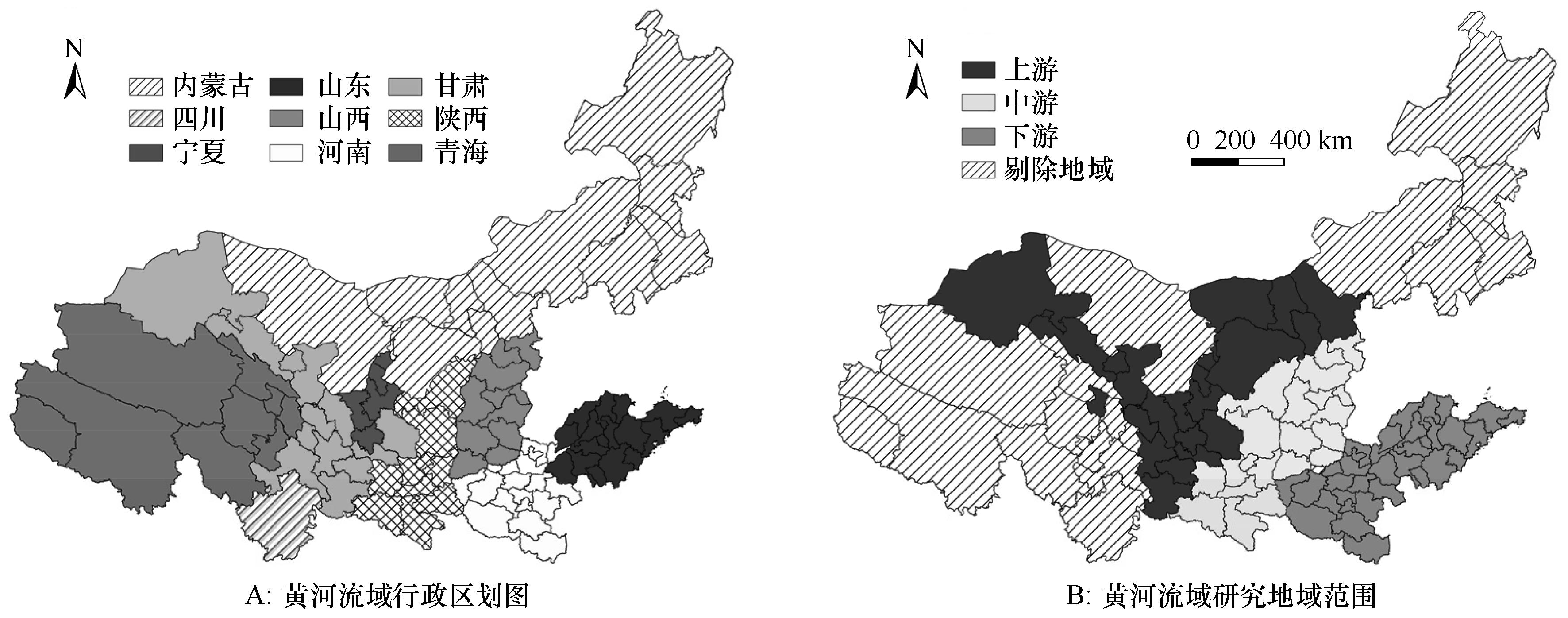
Fig.1 Schematic diagram of administrative divisions (A) and research area (B)
| 指标维度 | 指标 | 指标计算或说明(单位) | 属性 | 权重 |
|---|---|---|---|---|
| 经济融合 | 经济发展水平 | 人均GDP(元) | + | 0.097 |
| 非农产业比重 | 二三产业增加值/GDP(%) | + | 0.013 | |
| 二元对比系数 | 人均二三产业产值/人均一产产值 | - | 0.006 | |
| 人均粮食产量 | 粮食总产量/行政区总人口(kg) | + | 0.043 | |
| 社会融合 | 城乡居民收入比 | 城镇人均可支配收入/农村人均可支配收入 | - | 0.013 |
| 城乡居民医疗保障 | 城乡每万人拥有医生数(人) | + | 0.079 | |
| 城乡居民教育保障 | 城乡每万人拥有中小学教师数(人) | + | 0.025 | |
| 人口城市化 | 城镇人口/行政区总人口(%) | + | 0.043 | |
| 居民消费水平 | 人均社会商品零售总额(元) | + | 0.126 | |
| 空间融合 | 路网密度 | 公路通车里程/行政区土地面积(km·km-2) | + | 0.070 |
| 城市空间扩张 | 建成区面积/行政区土地面积(%) | + | 0.157 | |
| 交通通达性 | 每万人拥有公共汽车数(辆) | + | 0.062 | |
| 城乡互联网普及率 | 互联网用户数/行政区总户数(%) | + | 0.131 | |
| 环境融合 | 绿化覆盖率 | (%) | + | 0.015 |
| 工业固体废弃利用率 | (%) | + | 0.039 | |
| 生活污水集中处理率 | (%) | + | 0.028 | |
| 生活垃圾无害化处理率 | (%) | + | 0.054 |
Table 1 Evaluation index system of urban-rural integration development
| 指标维度 | 指标 | 指标计算或说明(单位) | 属性 | 权重 |
|---|---|---|---|---|
| 经济融合 | 经济发展水平 | 人均GDP(元) | + | 0.097 |
| 非农产业比重 | 二三产业增加值/GDP(%) | + | 0.013 | |
| 二元对比系数 | 人均二三产业产值/人均一产产值 | - | 0.006 | |
| 人均粮食产量 | 粮食总产量/行政区总人口(kg) | + | 0.043 | |
| 社会融合 | 城乡居民收入比 | 城镇人均可支配收入/农村人均可支配收入 | - | 0.013 |
| 城乡居民医疗保障 | 城乡每万人拥有医生数(人) | + | 0.079 | |
| 城乡居民教育保障 | 城乡每万人拥有中小学教师数(人) | + | 0.025 | |
| 人口城市化 | 城镇人口/行政区总人口(%) | + | 0.043 | |
| 居民消费水平 | 人均社会商品零售总额(元) | + | 0.126 | |
| 空间融合 | 路网密度 | 公路通车里程/行政区土地面积(km·km-2) | + | 0.070 |
| 城市空间扩张 | 建成区面积/行政区土地面积(%) | + | 0.157 | |
| 交通通达性 | 每万人拥有公共汽车数(辆) | + | 0.062 | |
| 城乡互联网普及率 | 互联网用户数/行政区总户数(%) | + | 0.131 | |
| 环境融合 | 绿化覆盖率 | (%) | + | 0.015 |
| 工业固体废弃利用率 | (%) | + | 0.039 | |
| 生活污水集中处理率 | (%) | + | 0.028 | |
| 生活垃圾无害化处理率 | (%) | + | 0.054 |
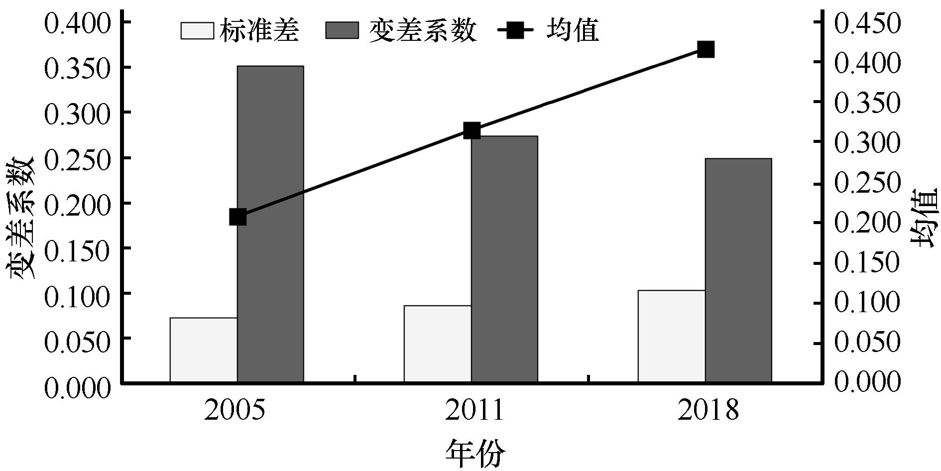
Fig.2 Absolute difference and relative difference of urban-rural integration development
| 年份 | 均值 | 标准差 | 变差系数 | ||||||
|---|---|---|---|---|---|---|---|---|---|
| 上游 | 中游 | 下游 | 上游 | 中游 | 下游 | 上游 | 中游 | 下游 | |
| 2005 | 0.191 | 0.169 | 0.243 | 0.071 | 0.062 | 0.063 | 0.374 | 0.364 | 0.257 |
| 2011 | 0.277 | 0.290 | 0.357 | 0.087 | 0.074 | 0.074 | 0.313 | 0.257 | 0.207 |
| 2018 | 0.375 | 0.363 | 0.478 | 0.093 | 0.085 | 0.088 | 0.247 | 0.234 | 0.184 |
Table 2 Absolute difference and relative difference of urban-rural integration development in upstream, midstream, downstream
| 年份 | 均值 | 标准差 | 变差系数 | ||||||
|---|---|---|---|---|---|---|---|---|---|
| 上游 | 中游 | 下游 | 上游 | 中游 | 下游 | 上游 | 中游 | 下游 | |
| 2005 | 0.191 | 0.169 | 0.243 | 0.071 | 0.062 | 0.063 | 0.374 | 0.364 | 0.257 |
| 2011 | 0.277 | 0.290 | 0.357 | 0.087 | 0.074 | 0.074 | 0.313 | 0.257 | 0.207 |
| 2018 | 0.375 | 0.363 | 0.478 | 0.093 | 0.085 | 0.088 | 0.247 | 0.234 | 0.184 |
| 年份 | 全局莫兰指数I | EI | VI | ZI | P |
|---|---|---|---|---|---|
| 2005 | 0.359 | -0.013 | 0.076 | 4.838 | 0.001 |
| 2011 | 0.428 | -0.013 | 0.076 | 5.783 | 0.001 |
| 2018 | 0.373 | -0.013 | 0.075 | 5.129 | 0.001 |
Table 3 Global Moran's I of urban-rural integration development
| 年份 | 全局莫兰指数I | EI | VI | ZI | P |
|---|---|---|---|---|---|
| 2005 | 0.359 | -0.013 | 0.076 | 4.838 | 0.001 |
| 2011 | 0.428 | -0.013 | 0.076 | 5.783 | 0.001 |
| 2018 | 0.373 | -0.013 | 0.075 | 5.129 | 0.001 |
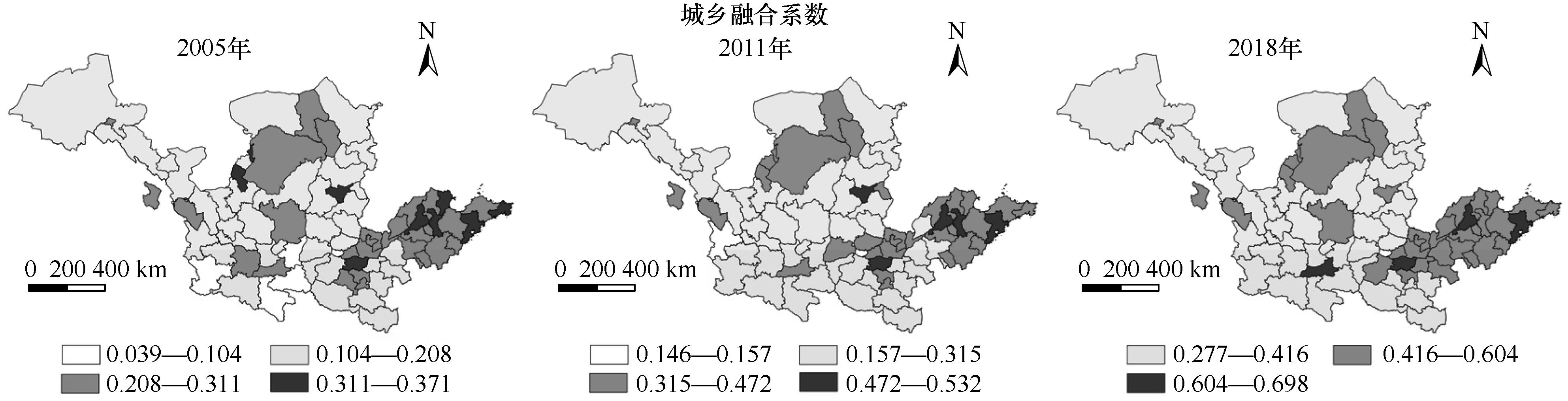
Fig.3 Spatial differentiation of urban-rural integration development

Fig.4 Local Moran's I of urban-rural integration development
| 年份 | 居民消费水平 | 城市空间扩张 | 经济发展水平 | 交通 通达性 | 人口 城市化 |
|---|---|---|---|---|---|
| 均值 | 0.843 | 0.821 | 0.710 | 0.688 | 0.649 |
| 2005 | 0.816 | 0.786 | 0.744 | 0.731 | 0.689 |
| 2011 | 0.841 | 0.808 | 0.656 | 0.715 | 0.585 |
| 2018 | 0.873 | 0.870 | 0.729 | 0.618 | 0.673 |
Table 4 Pearson correlation coefficients of internal factors
| 年份 | 居民消费水平 | 城市空间扩张 | 经济发展水平 | 交通 通达性 | 人口 城市化 |
|---|---|---|---|---|---|
| 均值 | 0.843 | 0.821 | 0.710 | 0.688 | 0.649 |
| 2005 | 0.816 | 0.786 | 0.744 | 0.731 | 0.689 |
| 2011 | 0.841 | 0.808 | 0.656 | 0.715 | 0.585 |
| 2018 | 0.873 | 0.870 | 0.729 | 0.618 | 0.673 |
| 模型参数 | 2005年 | 2011年 | 2018年 |
|---|---|---|---|
| 残差平方和 | 0.032 | 0.033 | 0.039 |
| 有效参数数量 | 7.012 | 17.450 | 11.982 |
| Sigma | 0.021 | 0.023 | 0.024 |
| AICc | -375.383 | -354.139 | -352.231 |
| R2 | 0.924 | 0.945 | 0.955 |
| 校正R2 | 0.917 | 0.930 | 0.947 |
Table 5 Parameters of GWR model in 2005, 2011 and 2018
| 模型参数 | 2005年 | 2011年 | 2018年 |
|---|---|---|---|
| 残差平方和 | 0.032 | 0.033 | 0.039 |
| 有效参数数量 | 7.012 | 17.450 | 11.982 |
| Sigma | 0.021 | 0.023 | 0.024 |
| AICc | -375.383 | -354.139 | -352.231 |
| R2 | 0.924 | 0.945 | 0.955 |
| 校正R2 | 0.917 | 0.930 | 0.947 |
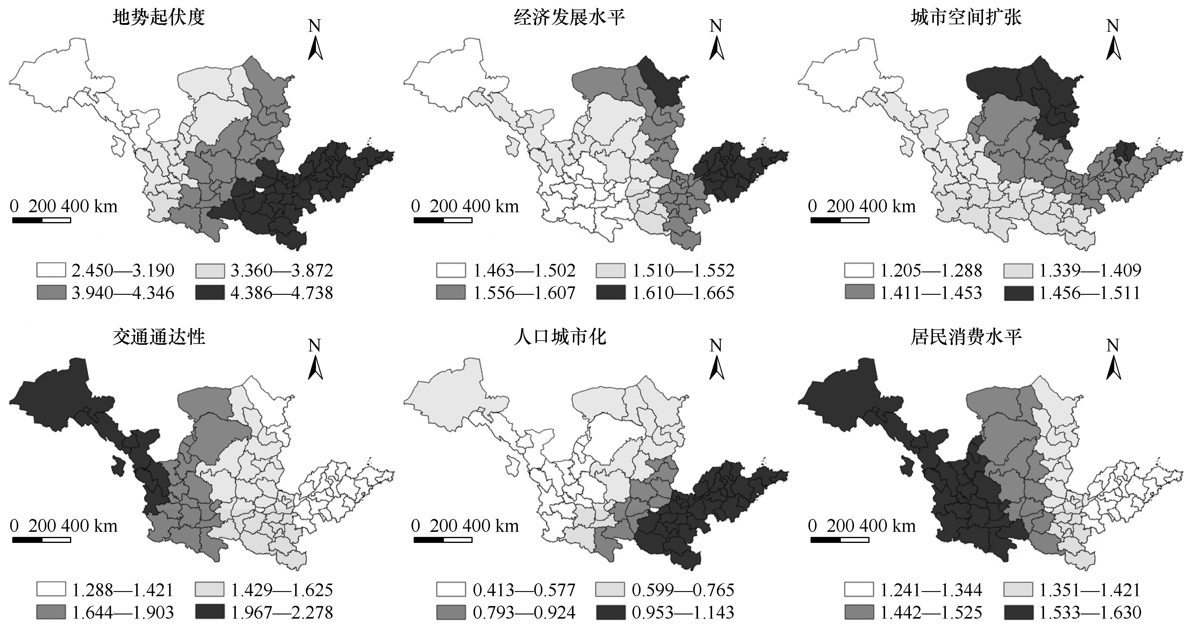
Fig.5 Spatial distribution of GWR model regression coefficient
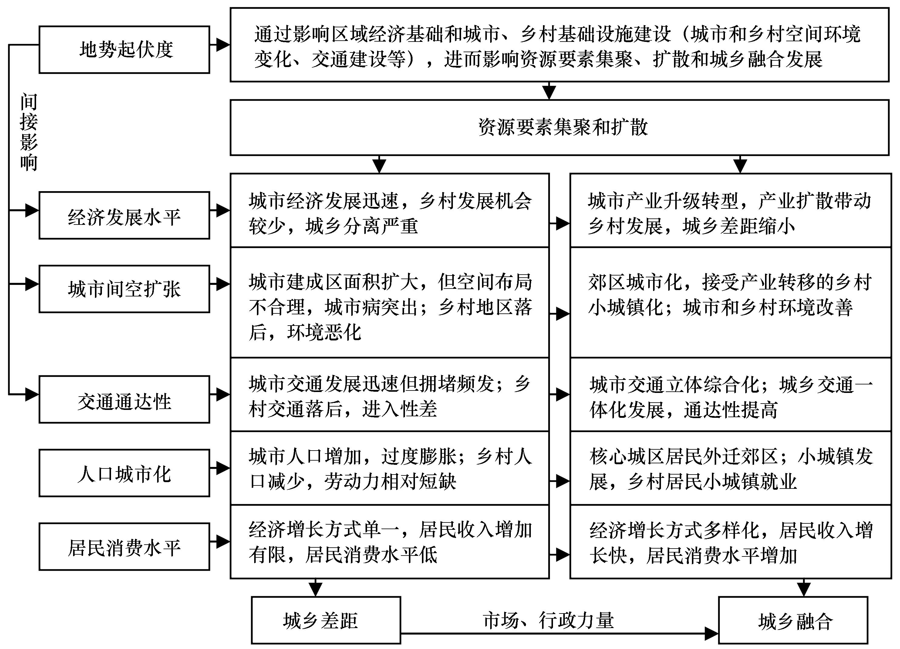
Fig.6 Dynamic mechanism of spatio-temporal evolution of urban-rural integration development
| 1 | 张海鹏.中国城乡关系演变70年:从分割到融合[J].中国农村经济,2019(3):2-18. |
| 2 | 刘彦随,严镔,王艳飞.新时期中国城乡发展的主要问题与转型对策[J].经济地理,2016,36(7):1-8. |
| 3 | 刘先江.马克思恩格斯城乡融合理论及其在中国的应用与发展[J].社会主义研究,2013(6):36-40. |
| 4 | 刘彦随.中国新时代城乡融合与乡村振兴[J].地理学报,2018,73(4):637-650. |
| 5 | 何仁伟.城乡融合与乡村振兴:理论探讨、机理阐释与实现路径[J].地理研究,2018,37(11):2127-2140. |
| 6 | 何仁伟,张海朋,李立娜.非特色型产业模式及其对乡村振兴的启示[J].中国沙漠,2021,41(3):81-91. |
| 7 | 王颖,孙平军,李诚固,等.2003年以来东北地区城乡协调发展的时空演化[J].经济地理,2018,38(7):59-66. |
| 8 | 徐美,刘春腊.中国城乡统筹绩效评估与城乡统筹趋势的相关性分析[J].自然资源学报,2012,27(5):734-746. |
| 9 | 李瑾,冯献,郭美荣,等.城乡一体化发展的时空演变特征与省区差异性分析[J].中国农业资源与区划,2017,38(11):67-77. |
| 10 | 吕连菊,阚大学.城乡一体化发展效率的测度及其分析[J].中国农业资源与区划,2021,42(2):176-183. |
| 11 | 周佳宁,邹伟,秦富仓,等.值化理念下中国城乡融合多维审视级影响因素[J].地理研究,2020,39(8):1836-1851. |
| 12 | 范昊,景普秋.基于互动融合的中国城乡关联-共生发展区域测度研究[J].商业研究,2018(8):45-54. |
| 13 | Liu Y, Lu S, Chen Y.Spatio-temporal change of urban-rural equalized development patterns in China and its driving factors[J].Journal of Rural Studies,2013,32(32):320-330. |
| 14 | Liu Y, Cong S, Li Y.Differentiation regularity of urban-rural equalized development at prefecture-level city in China[J].Journal of Geographical Sciences,2015,25(9):1075-1088. |
| 15 | 郭海红,刘新民,刘录敬.中国城乡融合发展的区域差距及动态演化[J].经济问题探索,2020(10):1-14. |
| 16 | 周佳宁,邹伟,秦富仓,等.值化理念下中国城乡融合多维审视及影响因素[J].地理研究,2020,39(8):1836-1851. |
| 17 | 窦旺胜,王成新,蒋旭,等.基于乡村振兴视角的山东省城乡融合发展水平研究[J].湖南师范大学自然科学学报,2019,42(6):1-8. |
| 18 | 张海朋,何仁伟,李光勤,等.大都市区城乡融合系统耦合协调度时空演化及其影响因素:环首都地区为例[J].经济地理,2020,40(11):56-66. |
| 19 | 周佳宁,毕雪昊,邹伟.“流空间”视域下淮海经济区城乡融合发展驱动机制[J].自然资源学报,2020,35(8):1881-1896. |
| 20 | 张新林,仇方道,朱传耿.时空交互视角下淮海经济区城乡融合发展水平演化[J].自然资源学报,2020,35(8):1867-1880. |
| 21 | 谢守红,周芳冰,吴天灵,等.长江三角洲城乡融合发展评价与空间格局演化[J].城市发展研究,2020,27(3):28-32. |
| 22 | 刘融融,胡佳欣,王星.西北地区城乡融合发展时空特征与影响因素研究[J].兰州大学学报(社会科学版),2019,47(6):106-118. |
| 23 | 许彩铃,李建建.城乡融合发展的科学内涵与实现路径:基于马克思主义城乡管理理论的思考[J].经济学家,2019(1):96-103. |
| 24 | 张毓雄,汤跃跃.我国城乡融合发展的整体性研究与反思:基于主题检索的CSSCI文献[J].社会科学家,2018(4):64-69. |
| 25 | 周晓艳,郝慧迪,叶信岳,等.黄河流域区域经济差异的时空动态分析[J].人文地理,2016(5):119-125. |
| 26 | 李光勤,方徐兵.黄河流域绿色发展水平时空演变特征[J].中国沙漠,2021,41(4):140-150. |
| 27 | 谢磊.中部地区“经济-社会-生态”城市化时空格局测度[D].长沙:湖南师范大学,2014. |
| 28 | 谢磊,李景保.江苏省旅游经济空间差异及影响因素分析[J].兰州财经大学学报,2017,33(1):94-102. |
| 29 | Wu X, Cui P.A study of the time-space evolution characteristics of urban-rural integration development in a mountainousarea based on ESDA-GIS:The case of the Qinling-Daba Mountains in China[J].Sustainability,2016,8(11):1085. |
| Viewed | ||||||
|
Full text |
|
|||||
|
Abstract |
|
|||||
©2018Journal of Desert Research
Tel:0931-8267545
Email:caiedit@lzb.ac.cn;desert@lzb.ac.cn
Support:Magtech