中国沙漠 ›› 2024, Vol. 44 ›› Issue (4): 111-125.DOI: 10.7522/j.issn.1000-694X.2024.00003
卜凡蕊( ), 刘颖, 邹学勇, 张春来
收稿日期:2023-10-28
修回日期:2024-01-05
出版日期:2024-07-20
发布日期:2024-08-29
作者简介:卜凡蕊(1999—),女,安徽亳州人,博士研究生,主要从事土壤风蚀与荒漠化防治研究。E-mail: fanrui@mail.bnu.edu.cn
基金资助:
Fanrui Bu(), Ying Liu, Xueyong Zou, Chunlai Zhang
Received:2023-10-28
Revised:2024-01-05
Online:2024-07-20
Published:2024-08-29
摘要:
在恢复或重建干旱地区的沙地植被时,降水和浅层地下水是决定植被稳定性的关键因素。只有在植被需水量、降水量和地下水补充量达到平衡状态时,植被才能维持稳定,其防风固沙功能才具有可持续性。选择毛乌素沙地和科尔沁沙地,利用具有连续时相的植被覆盖度、气象和地下水观测数据,研究了沙地水分动态变化、植被需水与水分供给的平衡关系。结果表明:(1)毛乌素沙地和科尔沁沙地生长季植被覆盖度分别与前一年、当年的降水量相关性最高,各栅格缓冲区对地下水的响应也多存在一年的滞后性,不同类型植被对降水量和地下水变化发生响应的滞后时间不同。(2)两个沙地的植被生长季各月植被需水量和月平均植被需水量均呈现上升趋势,空间变化差异显著。(3)毛乌素沙地和科尔沁沙地植被需水的主要来源均为地下水,地下水位下降可能导致植被不可持续;由于自然地理差异,毛乌素沙地更依赖降水,科尔沁沙地对地下水更敏感。(4)植被稳定性具有周期性,周期为2~24年。
中图分类号:
卜凡蕊, 刘颖, 邹学勇, 张春来. 中国东部典型沙地植被稳定性与水资源关系特征[J]. 中国沙漠, 2024, 44(4): 111-125.
Fanrui Bu, Ying Liu, Xueyong Zou, Chunlai Zhang. Vegetation sustainability in relation to water resources in typical sandy areas of eastern China[J]. Journal of Desert Research, 2024, 44(4): 111-125.
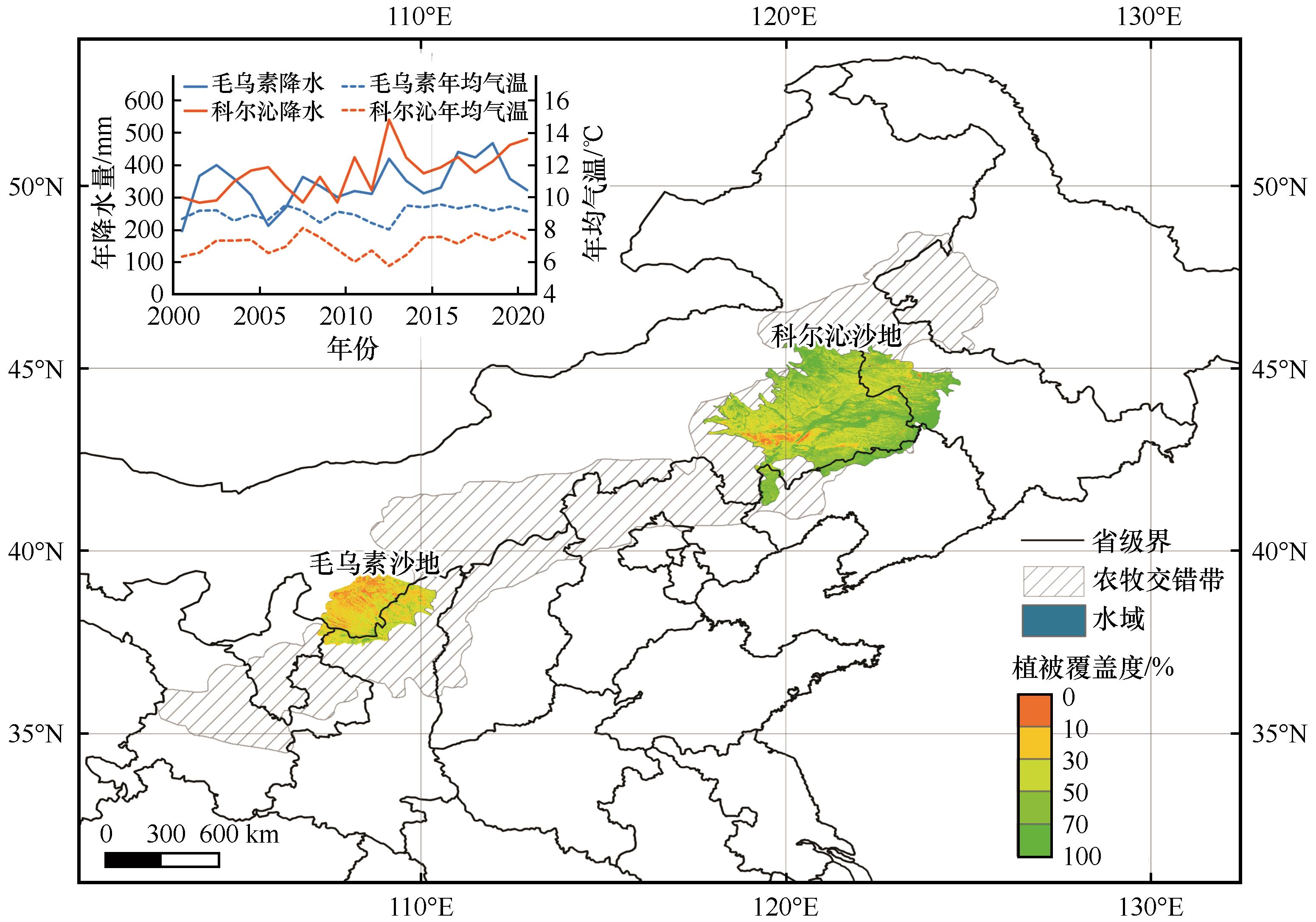
图1 研究区位置和生长季多年平均植被覆盖度及2000—2020年降水量与气温时间序列
Fig.1 The location of the study areas, multi-year average vegetation coverage in the growing season (VCave) and time series of precipitation (P) and temperature during 2000-2020
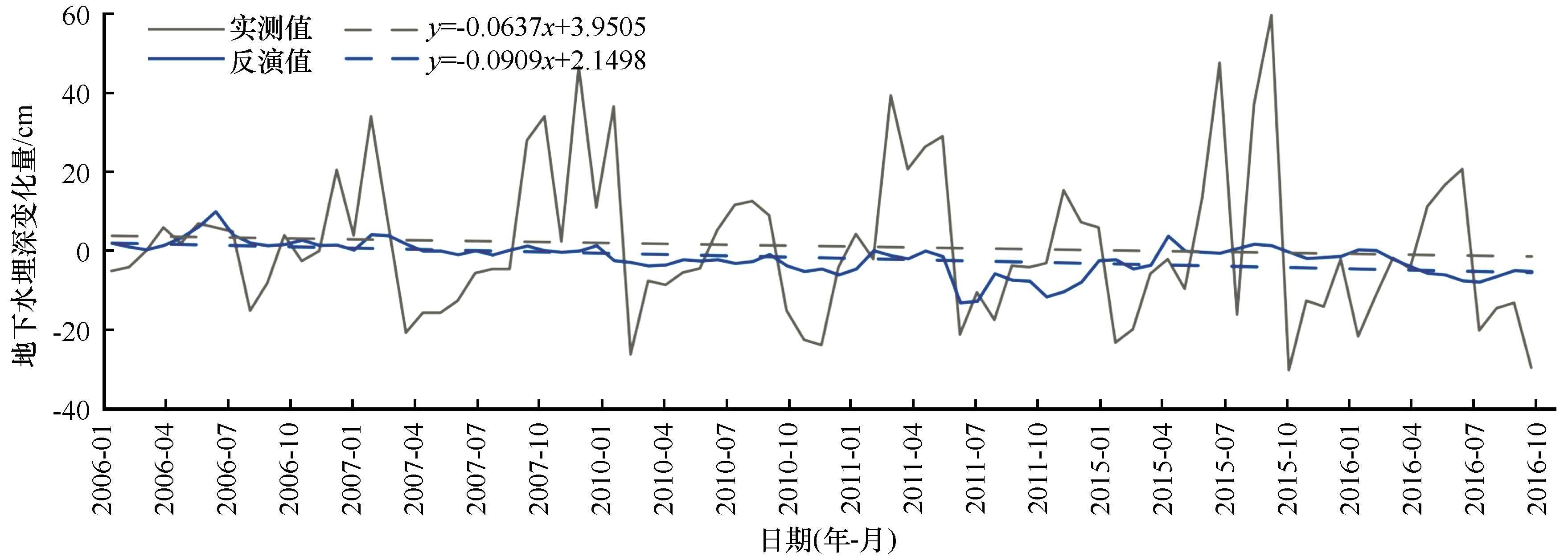
图2 观测点栅格缓冲区和卫星反演栅格数据的地下水埋深的变化趋势对比
Fig.2 Comparison of changes in groundwater depth between grid buffer zone and satellite retrieval grid
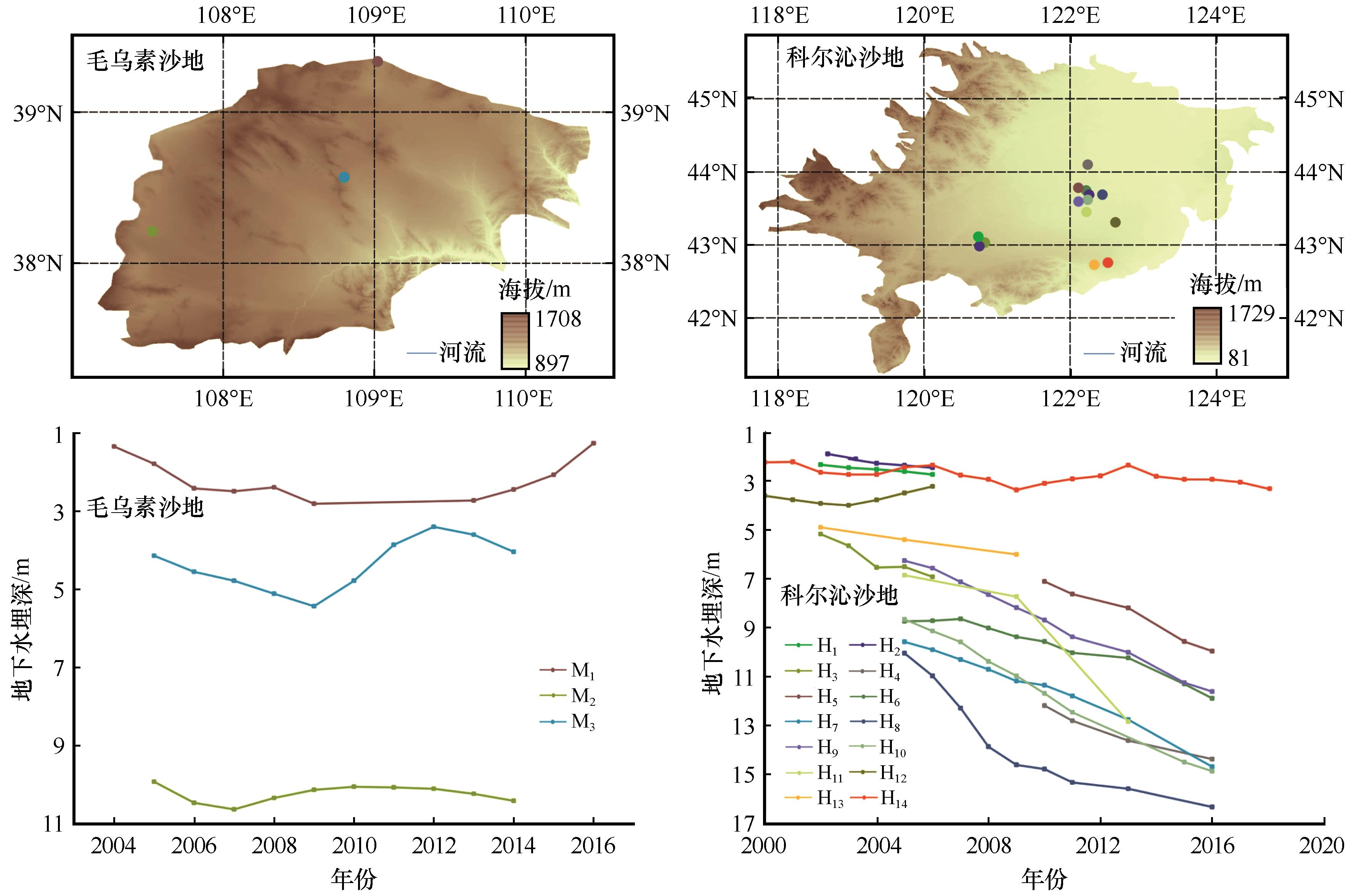
图3 地下水观测点分布和观测期地下水埋深变化
Fig.3 Distribution of groundwater observation points, and groundwater depth during the observation period
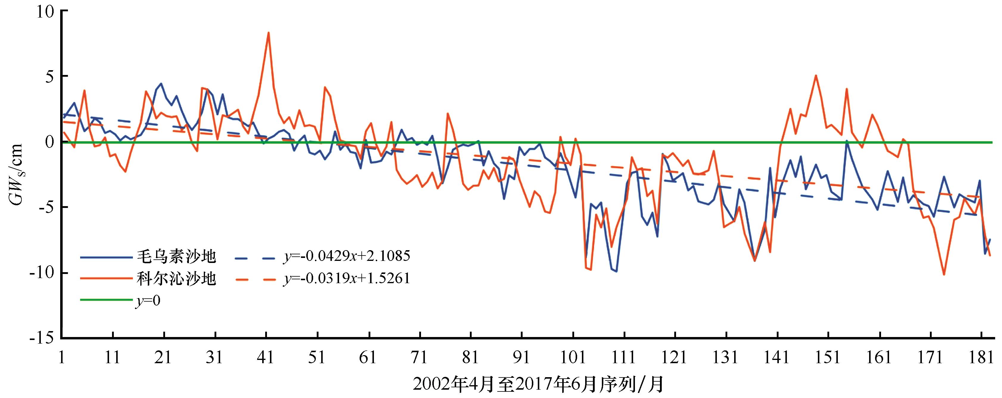
图4 2002年4月至2017年6月毛乌素沙地和科尔沁沙地地下水变化量(GWs)的逐月序列
Fig.4 Monthly series of groundwater changes (GWs) in Mu Us Sandy Land and Horqin Sandy Land during April 2002 to June 2017
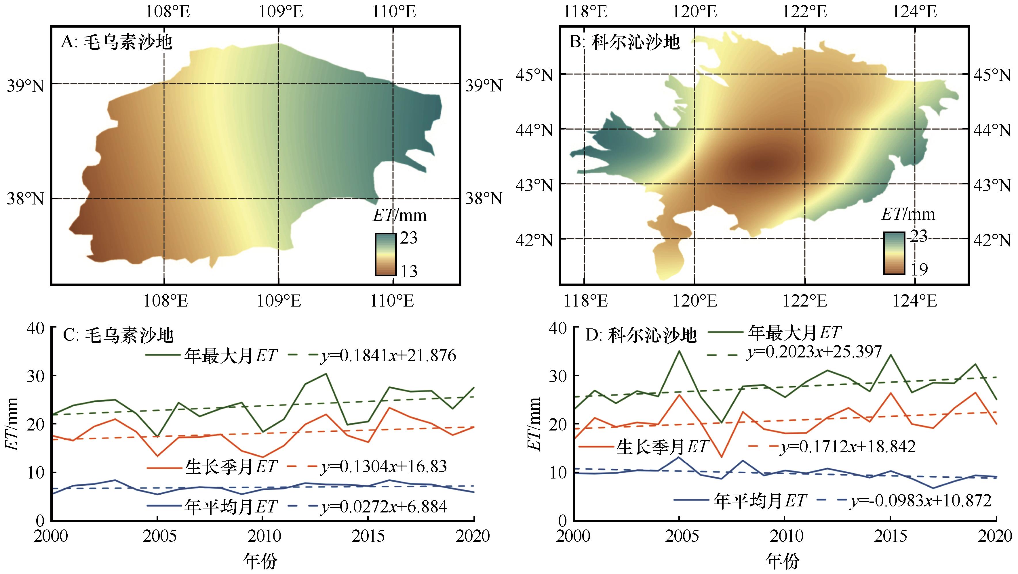
图5 2000—2020年毛乌素沙地和科尔沁沙地生长季多年平均蒸发量(ET)空间分布(A和B)及时间变化(C和D)
Fig.5 Spatial distribution of multi-year average intra-annual evaporation (ET,A and B), and temporal variation (C and D) in Mu Us Sandy Land and Horqin Sandy Land, 2000-2020
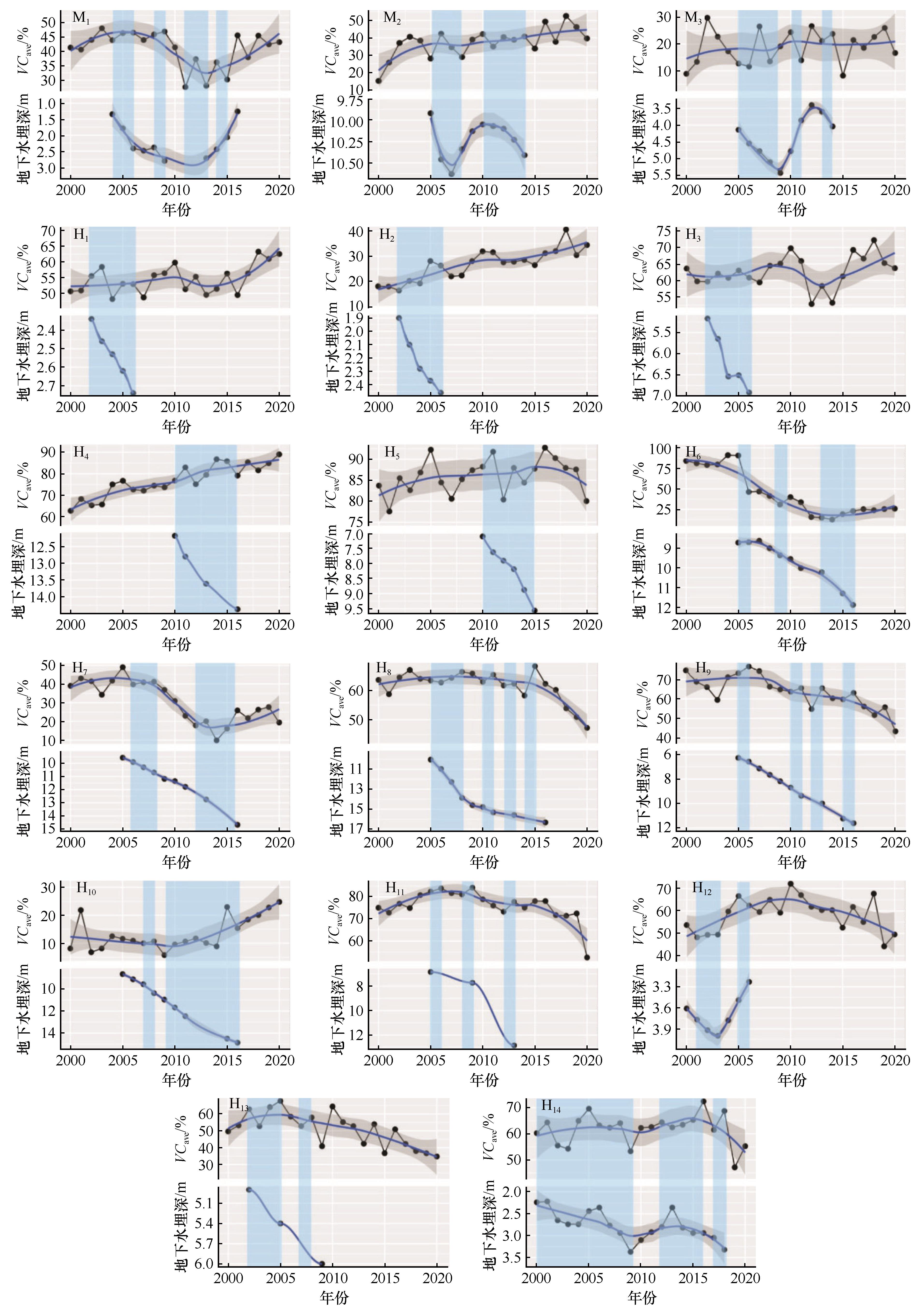
图6 毛乌素沙地和科尔沁沙地栅格缓冲区生长季平均植被覆盖度(VCave)与当年地下水埋深的关系
Fig.6 Relationship between average vegetation coverage (VCave) in growing season and groundwater depth in that year of Mu Us Sandy Land and Horqin Sandy Land
图7 毛乌素沙地和科尔沁沙地栅格缓冲区生长季平均植被覆盖度(VCave)与前一年地下水埋深的关系
Fig.7 Relationship between average vegetation coverage (VCave) in growing season and groundwater depth in the previous year of Mu Us Sandy Land and Horqin Sandy Land
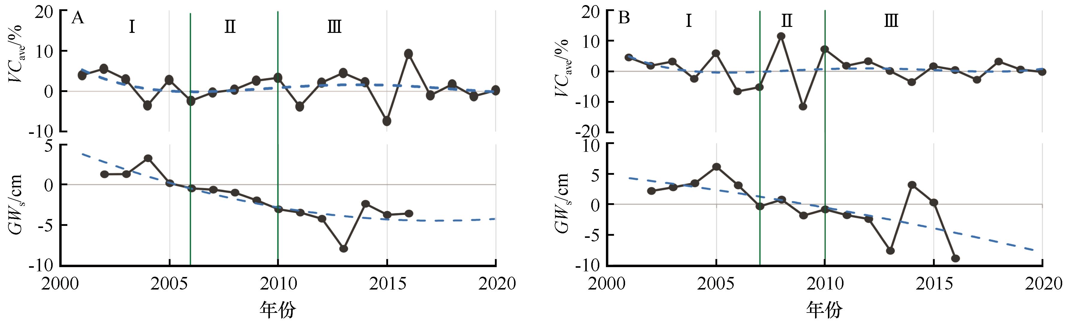
图8 与上一年相比,毛乌素沙地(A)和科尔沁沙地(B)生长季平均植被覆盖度(VCave)与地下水变化量(GWs)动态时间序列(2000—2020年)
Fig.8 Dynamic time series of average vegetation coverage (VCave) in the growing season and groundwater variation (GWs) in Mu Us Sandy Land (A) and Horqin Sandy Land (B), 2000-2020
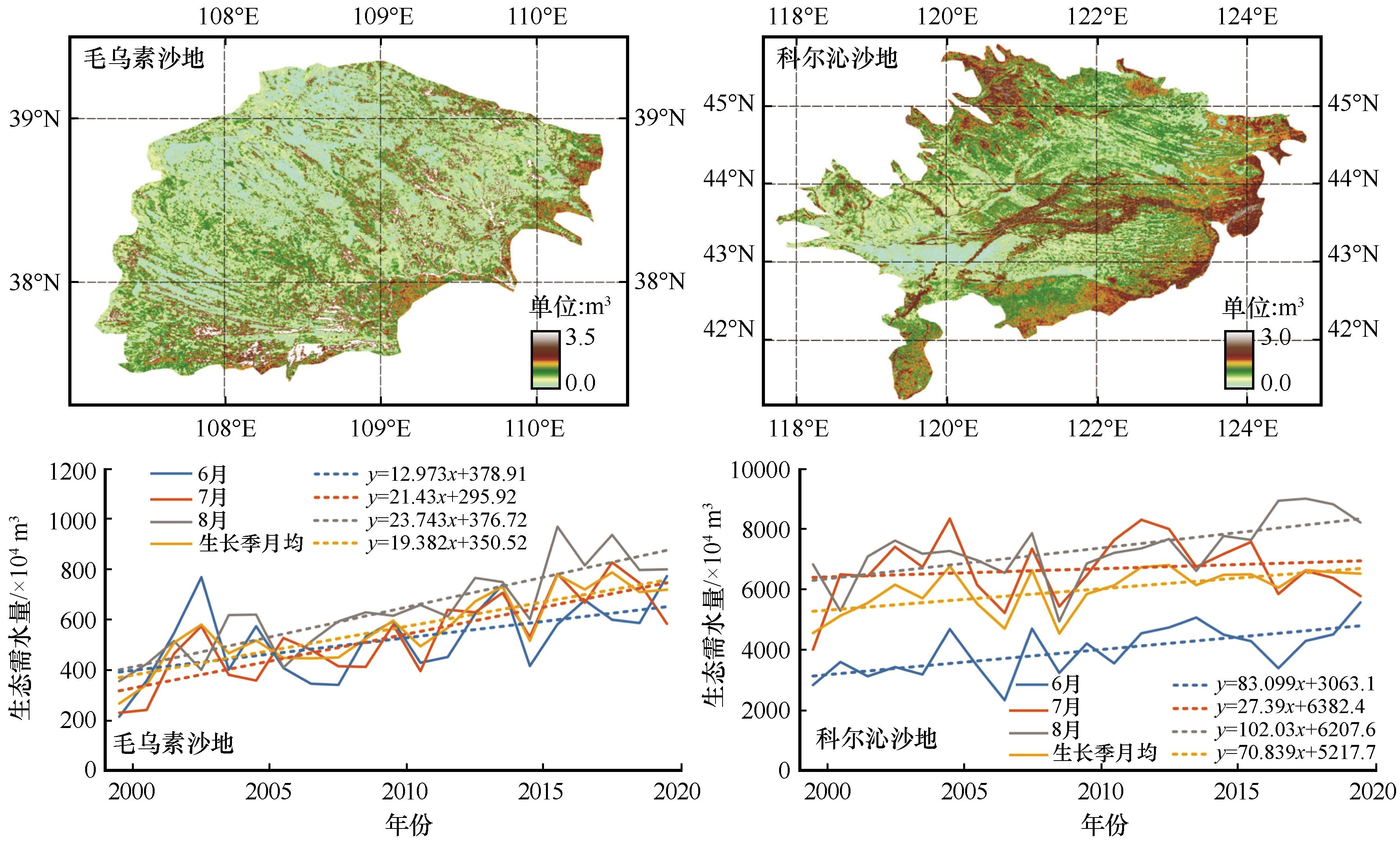
图9 毛乌素沙地和科尔沁沙地2000—2020年统计面积单元内植被生长季需水量平均值空间分布、生长季内各月和月均植被需水量
Fig.9 Mean spatial distribution of vegetation water demand (W) in growing season, monthly and monthly average vegetation water demand (W) in growing season in the statistical area unit of Mu Us Sandy Land and Horqin Sandy Land, 2000-2020
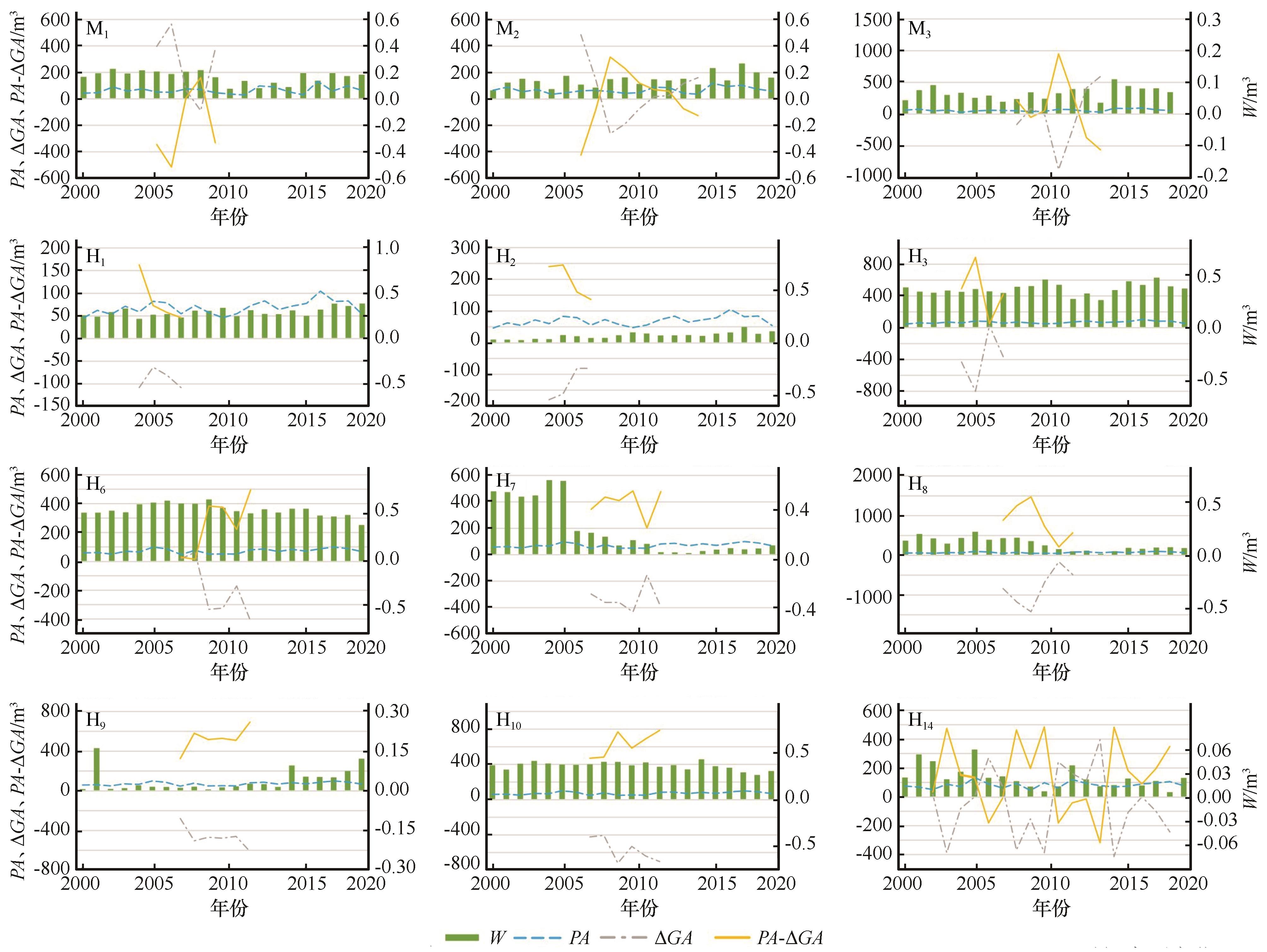
图10 毛乌素沙地(M1~M3)与科尔沁沙地(H1~H3、H6~H10、H14)栅格缓冲区内的W、PA、ΔGA、PA-ΔGA时间序列变化
Fig.10 Time series variation of W, PA, ΔGA and PA-ΔGA in the raster buffer cells for observation of Mu Us Sandy Land (M1-M3) and Horqin Sandy Land (H1-H3, H6-H10, H14)
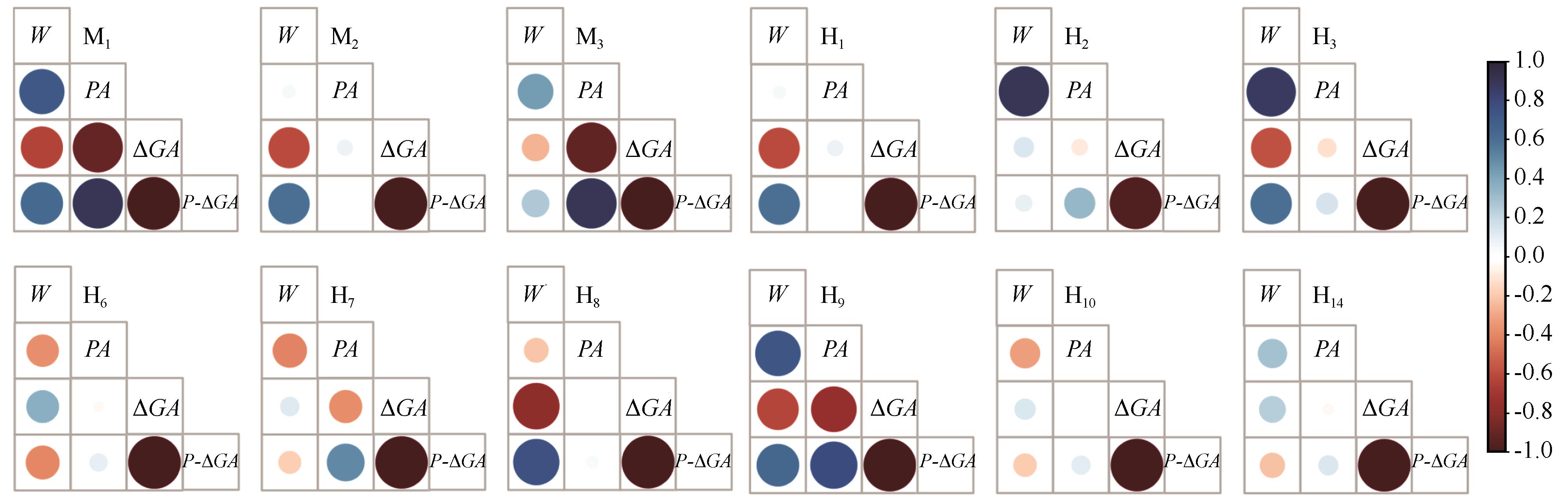
图11 毛乌素沙地(M1~M3)与科尔沁沙地(H1~H3、H6~H10、H14)栅格缓冲区内的W、PA、ΔGA、PA-ΔGA相关性
Fig.11 Correlation between W, PA, ΔGA and PA-ΔGA in the raster buffer cells for observation of Mu Us Sandy Land (M1-M3) and Horqin Sandy Land (H1-H3, H6-H10, H14)
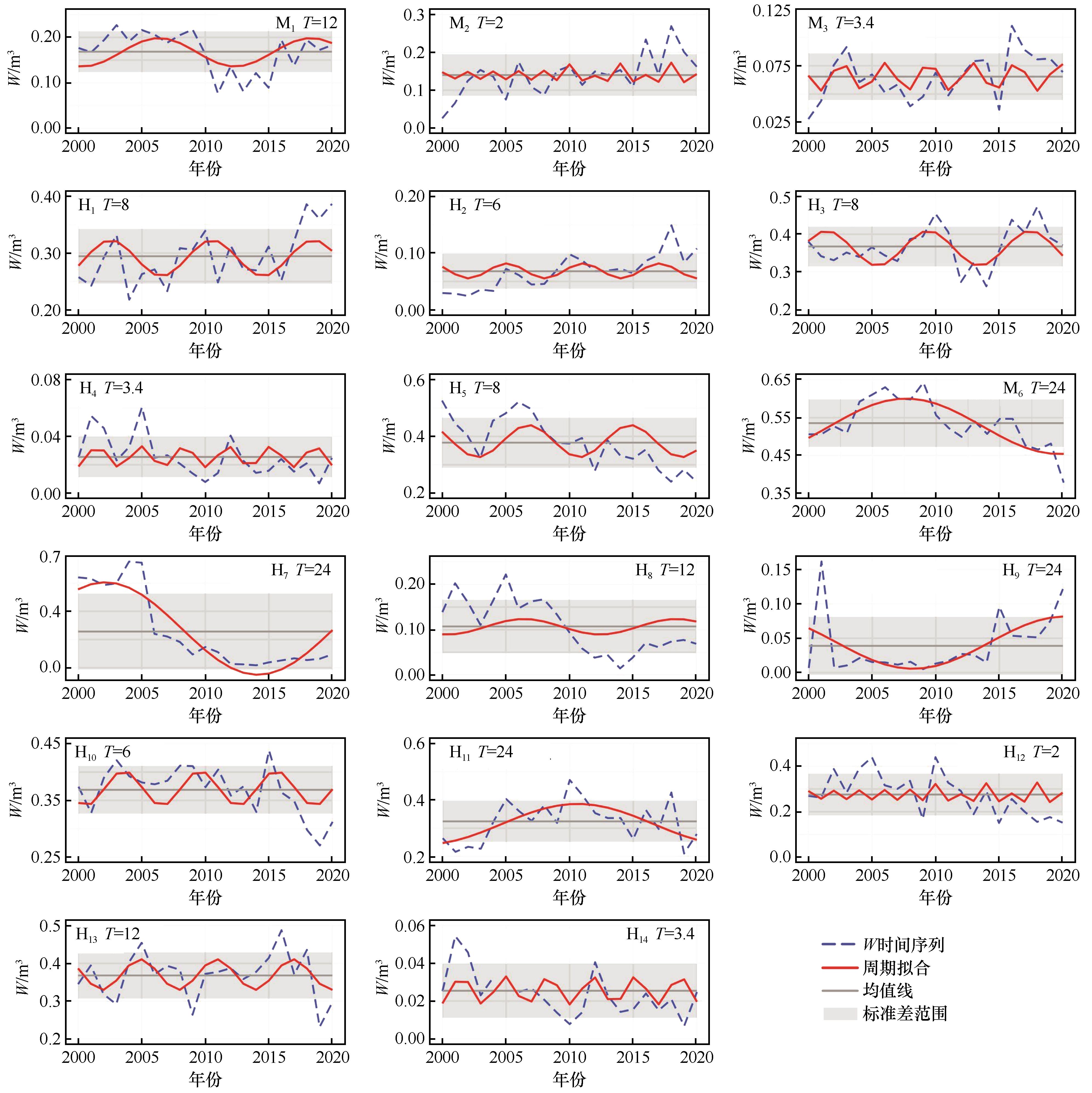
图12 毛乌素沙地与科尔沁沙地观测点栅格缓冲区生长季植被需水量(W)周期拟合
Fig.12 Cyclical fit of vegetation water demand (W) in the growing season of the raster buffer cells for observation in Mu Us Sandy Land and Horqin Sandy Land

图13 中国东部典型沙地植被稳定性与荒漠化问题
Fig.13 Vegetation stability and desertification in typical sandy lands of eastern China
| 观测点 | W/m3 | VC/% | P/m3 | 地下水埋深/m |
|---|---|---|---|---|
| M1 | 0.12~0.21 | 37~47 | 40~146 | 1.34~2.81 |
| M2 | 0.10~0.19 | 28~46 | 48~105 | 9.92~10.41 |
| M3 | 0.05~0.09 | 20~27 | 31~108 | 3.40~5.43 |
| H4 | 0.01~0.04 | 76~94 | 51~112 | 12.18~14.37 |
| H5 | 0.29~0.46 | 59~69 | 55~96 | 7.11~9.96 |
| H6 | 0.47~0.60 | 69~80 | 52~97 | 8.64~11.88 |
| H7 | 0.00~0.50 | 11~60 | 52~111 | 9.90~14.68 |
| H8 | 0.05~0.16 | 23~44 | 52~110 | 10.97~15.32 |
| H9 | 0.00~0.08 | 4~24 | 52~110 | 6.26~10.00 |
| H10 | 0.33~0.41 | 60~68 | 52~112 | 8.66~12.46 |
| H11 | 0.25~0.40 | 52~69 | 55~134 | 7.73~12.84 |
| H12 | 0.18~0.37 | 44~63 | 63~120 | 3.61~4.00 |
| H13 | 0.31~0.43 | 53~70 | 65~120 | 4.90~6.00 |
| H14 | 0.01~0.04 | 7~22 | 50~149 | 2.22~3.37 |
表1 各栅格缓冲区植被呈稳定时参数范围
Table 1 The range of parameters when the vegetation of raster buffer cells were stable
| 观测点 | W/m3 | VC/% | P/m3 | 地下水埋深/m |
|---|---|---|---|---|
| M1 | 0.12~0.21 | 37~47 | 40~146 | 1.34~2.81 |
| M2 | 0.10~0.19 | 28~46 | 48~105 | 9.92~10.41 |
| M3 | 0.05~0.09 | 20~27 | 31~108 | 3.40~5.43 |
| H4 | 0.01~0.04 | 76~94 | 51~112 | 12.18~14.37 |
| H5 | 0.29~0.46 | 59~69 | 55~96 | 7.11~9.96 |
| H6 | 0.47~0.60 | 69~80 | 52~97 | 8.64~11.88 |
| H7 | 0.00~0.50 | 11~60 | 52~111 | 9.90~14.68 |
| H8 | 0.05~0.16 | 23~44 | 52~110 | 10.97~15.32 |
| H9 | 0.00~0.08 | 4~24 | 52~110 | 6.26~10.00 |
| H10 | 0.33~0.41 | 60~68 | 52~112 | 8.66~12.46 |
| H11 | 0.25~0.40 | 52~69 | 55~134 | 7.73~12.84 |
| H12 | 0.18~0.37 | 44~63 | 63~120 | 3.61~4.00 |
| H13 | 0.31~0.43 | 53~70 | 65~120 | 4.90~6.00 |
| H14 | 0.01~0.04 | 7~22 | 50~149 | 2.22~3.37 |
| 1 | 国家林业局.三北防护林体系建设30年发展报告1978-2008[M].北京:中国林业出版社,2008. |
| 2 | 石莎,邹学勇,张春来,等.京津风沙源治理工程区植被恢复效果调查[J].中国水土保持科学,2009,7(2):86-92. |
| 3 | 李世东.中外退耕还林还草之比较及其启示[J].世界林业研究,2002,15(2):22-27. |
| 4 | Lyu Y L, Shi P J, Han G Y,et al.Desertification control practices in China[J].Sustainability,2020,12(8):3258. |
| 5 | Wang X H, Du Yan, Wang Z R,et al.Dynamic changes of the Mu Us Sandy Land and relevant causes[J].Polish Journal of Environmental Studies,2021,30(4):3815-3827. |
| 6 | Ma Z T, Wang W K, Zhang Z Y,et al.Assessing bare-soil evaporation from different water-table depths using lysimeters and a numerical model in the ordos basin,China[J].Hydrogeology Journal,2019,27:2707-2718. |
| 7 | 卢琦.荒漠生态学[M].北京:中国林业出版社,2019:14-15. |
| 8 | Wang J Y, Gao G Z, Jie D M,et al.Aeolian soils on the Eastern Side of the Horqin Sandy Land,China:a provenance and sedimentary environment reconstruction perspective[J].CATENA,2022,210:105945. |
| 9 | Dai Y, Daiki I, Jeison S,et al.MERIT Hydro:a high-resolution global hydrography map based on latest topography dataset[J].Water Resources Research,2019,55(6):5053-5073. |
| 10 | 赵哈林,赵学勇,张铜会,等.东北西部沙地近20年地下水变化动态及其成因分析[J].干旱区研究,2002,19(2):1-6. |
| 11 | Zhang M M, Wu X Q.The rebound effects of recent vegetation restoration projects in Mu Us Sandy Land of China[J].Ecological Indicators,2020,113:106228. |
| 12 | 格日乐.库布齐沙漠梭梭林地SPAC系统水分关系研究[D].北京:北京林业大学,2005. |
| 13 | 杨小平,梁鹏,张德国,等.中国东部沙漠/沙地全新世地层序列及其古环境[J].中国科学(地球科学),2019,49(8):1293-1307. |
| 14 | 朱震达,吴正,刘恕,等.中国沙漠概论[M].北京:科学出版社,1980. |
| 15 | Yan Q L, Zhu J J, Zheng X,et al.Causal effects of shelter forests and water factors on desertification control during 2000-2010 at the Horqin Sandy Land region,China[J].Journal of Forestry Research,2015,26(1):33-45. |
| 16 | 李宁,周海,任珩,等.不同地下水位处梭梭(Haloxylon ammodendron)水分来源特征[J].中国沙漠,2021,41(4):79-86. |
| 17 | 王根绪,程国栋.干旱荒漠绿洲景观空间格局及其受水资源条件的影响分析[J].生态学报,2000,20(3):363-368. |
| 18 | Horton J, Kolb T E, Hart S C.Physiological response to groundwater depth varies among species and with river flow regulation[J].Ecological Applications,2001,11(4):1046-1059. |
| 19 | Hanjra M, Qureshi M.Global water crisis and future food security in an era of climate change[J].Food Policy,2010,35(5):365-377. |
| 20 | Castle S L, Thomas B F, Reager J T,et al.Groundwater depletion during drought threatens future water security of the Colorado River Basin[J].Geophysical Research Letters,2015,41(16):5904-5911. |
| 21 | 蒋良群,陈曦,包安明.塔里木河下游地下水变化动态分析[J].干旱区地理,2005,28(1):33-37. |
| 22 | Marston L, Konar M, Cai X M,et al.Virtual groundwater transfers from overexploited aquifers in the United States[J].Proceedings of the National Academy of Sciences,2015,112 (28):8561-8566. |
| 23 | Cui L L, Shi J.Evaluation and comparison of growing season metrics in arid and semi-arid areas of northern China under climate change[J].Ecological Indicators,2021,121(10):107055. |
| 24 | 王姣月,秦树高,张宇清.毛乌素沙地植被水分利用效率的时空格局[J].中国沙漠,2020,40(5):120-129. |
| 25 | 王静茹,马龙,刘廷玺.1951-2012年科尔沁沙地气温、降水变化特征[J].干旱区研究,2016,33(1):49-58. |
| 26 | 史文娇,刘奕婷,石晓丽.四个历史时期中国北方农牧交错带界线数据集(1970-2010)[J].全球变化数据学报(中英文),2018,2(4):419-425. |
| 27 | 刘志民,余海滨.“山水林田湖草沙生命共同体”理念下的科尔沁沙地生态治理[J].中国沙漠,2022,42(1):34-40. |
| 28 | 石书兵.中国沙漠·沙地·沙生植物[M].北京:中国农业科学技术出版社,2013. |
| 29 | 国家林业和草原科学数据中心.三北防护林体系建设总体规划四期工程[EB/OL].[2024-04-10].. |
| 30 | 国家林业和草原局.中国退耕还林还草20年(1999-2019)[EB/OL].[2024-04-10].. |
| 31 | 王旭升,尹立河,方坤,等.鄂尔多斯浩勒报吉水源地开采地下水的环境影响分析[J].水文地质工程地质,2019,46(2):5-12. |
| 32 | 郑玉峰,王占义,方彪,等.鄂尔多斯市2005-2014年地下水位变化[J].中国沙漠,2015,35(4):1036-1040. |
| 33 | 赵玮,张铜会,赵学勇,等.近5 a来科尔沁沙地典型区域地下水埋深变化分析[J].中国沙漠,2008,28(5):995-1000. |
| 34 | 中国地质环境监测院.中国地质环境监测地下水位年鉴:2006[M].北京:中国大地出版社,2007. |
| 35 | 中国地质环境监测院.中国地质环境监测地下水位年鉴:2007[M].北京:中国大地出版社,2008. |
| 36 | 中国地质环境监测院.中国地质环境监测地下水位年鉴:2008[M].北京:中国大地出版社,2009. |
| 37 | 中国地质环境监测院.中国地质环境监测地下水位年鉴:2010[M].北京:中国大地出版社,2011. |
| 38 | 中国地质环境监测院.中国地质环境监测地下水位年鉴:2011[M].北京:中国大地出版社,2012. |
| 39 | 中国地质环境监测院.中国地质环境监测地下水位年鉴:2013[M].北京:中国大地出版社,2014. |
| 40 | 中国地质环境监测院.中国地质环境监测地下水位年鉴:2015[M].北京:中国大地出版社,2018. |
| 41 | Syed T H, Famiglietti J S, Matthew R,et al.Analysis of terrestrial water storage changes from GRACE and GLDAS[J].Water Resources Research,2008,44:W02433. |
| 42 | Cheung M W, Vijayakumar R.A guide to conducting a meta-analysis[J].Neuropsychol Review,2016,26(2):121-128. |
| 43 | 张高强.乌审召盆地植被、蒸散与地下水的相互关系研究[D].北京:中国地质大学(北京),2019. |
| 44 | Rohatgi,Ankit.WebPlotDigitizer user manual version 3.4[Z].http://arohatgi.info/WebPlotDigitizer/app:1-18. |
| 45 | 卜凡蕊,刘颖,邹学勇.中国东部典型沙地植被覆盖度对降水变化的响应[J].中国沙漠,2023,43(3):9-20. |
| 46 | Hargreaves G H, Samani Z A.Estimation of potential evapotranspiration[J].Journal of Irrigation and Drainage Division,1982,108(3):223-230. |
| 47 | 傅抱璞.论陆面蒸发的计算[J].大气科学,1981,5(1):23-31. |
| 48 | 王忠静,张子雄,索滢.干旱区凝结水评估及对水量平衡方程影响[J].水利学报,2019,50(6):710-720. |
| 49 | Churchill R V.Fourier Series and Boundary Value Problems[M].Now York,USA.McGraw-Hill,1963:322. |
| 50 | 李河.陕北榆林毛乌素沙地新开垦耕地空间分布特征:以靖边县为例[J].安徽农业科学,2021,49(21):79-81. |
| 51 | Lian J, Zhao X Y, Li X,et al.Detecting sustainability of desertification reversion:vegetation trend analysis in part of the agro-pastoral transitional zone in Inner Mongolia,China[J].Sustainability,2017,9(2):211. |
| 52 | Zhang G Q,Cheng,Y T, Liu H D,et al.Evaluation of the groundwater ecological water requirement in the southeast margin of otindag sandy land based on allowable groundwater depth drawdown[J].Water,2023,15(19):3504. |
| 53 | Zheng X, Zhu J J, Yan Q L,et al.Effects of land use changes on the groundwater table and the decline of pinus sylvestris var.mongolica plantations in southern Horqin Sandy Land,Northeast China[J].Agricultural Water Management,2012,109:94-106. |
| 54 | 张本兴,潘云,李小娟.中国不同气候区域Hargreaves模型的修正[J].地理与地理信息科学,2012,28(1):51-54. |
| 55 | Bao Y Z, Liu T X, Duan L M,et al.Comparison of an improved Penman-Monteith model and SWH model for estimating evapotranspiration in a meadow wetland in a semiarid region[J].The Science of the Total Environment,2021,795:148736. |
| 56 | Ngongondo C, Xu C, Tallaksen L,et al.Evaluation of the FAO Penman-Montheith,Priestley-Taylor and Hargreaves models for estimating reference evapotranspiration in southern Malawi[J].Hydrology Research,2013,44(4):706-722. |
| 57 | Meyer W S, Kondrlova G R, Koerber G R.Evaporation of perennial semi-arid woodland in southeastern Australia is adapted for irregular but common dry periods[J].Hydrological Processes,2015,29(17):3714-3726. |
| 58 | Zhang L, Hickel K, Dawes W R,et al.A Rational Function Approach for Estimating Mean Annual Evapotranspiration[J].Water Resources Research,2004,40(2):W02502. |
| 59 | Cheng C W, Liu W Z, Mu Z T,et al.Lumped variable representing the integrative effects of climate and underlying surface system:interpreting Budyko model parameter from earth system science perspective[J].Journal of Hydrology,2023,620:129379. |
| 60 | 韩松俊,胡和平,田富强.基于水热耦合平衡的塔里木盆地绿洲的年蒸散发[J].清华大学学报(自然科学版),2008,48(12):2070-2073. |
| 61 | Bian Y M, Dai H Y, Zhang Q L,et al.Spatial distribution of potential evapotranspiration trends in the Inner Mongolia Autonomous Region (1971-2016)[J].Theoretical and Applied Climatology,2020,140(3/4):1161-1169. |
| 62 | Zhang Y Q, Peña-Arancibia J L, McVicar T R,et al.Multi-decadal trends in global terrestrial evapotranspiration and its components[J].Scientific Reports,2016,6(1):19124. |
| 63 | 李小文,王祎婷.定量遥感尺度效应刍议[J].地理学报,2013,68(9):1163-1169. |
| 64 | Zhang Y Q, Kong D D, Gan R,et al.Coupled estimation of 500 m and 8-day resolution global evapotranspiration and gross primary production in 2002-2017[J].Remote Sensing of Environment,2019,222:165-182. |
| 65 | Mao D H, Wang Z M, Wu B F,et al.Land degradation and restoration in the arid and semiarid zones of China:quantified evidence and implications from satellites[J].Land Degradation Development,2018,29(11):3841-3851. |
| [1] | 康小虎, 李琳, 孙超, 刘鹄. 基于GRACE与GLDAS数据的黄河流域甘肃段地下水可持续性研究[J]. 中国沙漠, 2024, 44(2): 196-206. |
| [2] | 王永鹏, 阿里木江, 周龙, 杨鹏年, 冯思阳, 王延文. 塔里木河下游生态输水效应[J]. 中国沙漠, 2023, 43(4): 231-240. |
| [3] | 牛亚毅, 刘蔚, 董佳蕊, 连杰, 王旭洋, 李玉强. 科尔沁沙地1961—2021年主要气象要素的变化特征[J]. 中国沙漠, 2023, 43(4): 263-273. |
| [4] | 黄韵杰, 李永刚, 尹本丰, 张元明. 齿肋赤藓( Syntrichia caninervis )氮磷计量特征对降水量的响应[J]. 中国沙漠, 2023, 43(2): 1-10. |
| [5] | 张琦, 苏永红, 冯起, 鱼腾飞, 马小红. 以地下水位估算的荒漠河岸胡杨( Populus euphratica )林生态系统地下水蒸散发[J]. 中国沙漠, 2022, 42(6): 243-254. |
| [6] | 李琳, 刘鹄, 孙程鹏, 赵文智. 基于地下水位与土壤含水量的地下水蒸散发估算[J]. 中国沙漠, 2022, 42(6): 277-287. |
| [7] | 李倩, 马龙, 刘廷玺, 王硕. 采煤对海流兔流域大气降水-地表水-地下水-矿井水转化关系的影响[J]. 中国沙漠, 2022, 42(5): 146-157. |
| [8] | 郭新新, 岳平, 李香云, 乔静娟, 胡亚, 左小安. 降水量对荒漠草原骆驼蓬( Peganum harmala )地上生物量的影响[J]. 中国沙漠, 2022, 42(2): 164-172. |
| [9] | 周生辉, 刘廷玺, 段利民, 冀如, 张春雨. 毛乌素沙地海流兔河流域水文地质特征[J]. 中国沙漠, 2021, 41(5): 103-110. |
| [10] | 苏天燕, 刘子涵, 丛安琪, 毛伟, 杨秋. 地下水埋深对半干旱区典型植物群落土壤酶活性的影响[J]. 中国沙漠, 2021, 41(4): 185-194. |
| [11] | 庄立超, 王乃昂, 张洵赫, 赵力强, 苏贤保. 巴丹吉林沙漠典型湖冰冻结-消融的空间模式差异[J]. 中国沙漠, 2021, 41(3): 214-223. |
| [12] | 杨文斌, 王涛, 熊伟, 邹慧, 冯伟, 程一本, 廉泓林. 低覆盖度治沙理论的核心水文原理概述[J]. 中国沙漠, 2021, 41(3): 75-80. |
| [13] | 何建华, 秦文华, 郭嘉兵, 陈沛源, 马金珠. 敦煌绿洲地下水微量元素分布特征及其成因[J]. 中国沙漠, 2021, 41(2): 109-119. |
| [14] | 苏天燕, 刘文杰, 杨秋, 毛伟. 土壤碳循环对地下水位的响应研究进展[J]. 中国沙漠, 2020, 40(5): 180-189. |
| [15] | 王理想, 蔡明玉, 白雪莲, 乔荣荣, 季树新, 常学礼. 乌兰布和沙漠东南缘湖泊群消涨与驱动因素[J]. 中国沙漠, 2020, 40(2): 59-67. |
| 阅读次数 | ||||||
|
全文 |
|
|||||
|
摘要 |
|
|||||
©2018中国沙漠 编辑部
地址: 兰州市天水中路8号 (730000)
电话:0931-8267545
Email:caiedit@lzb.ac.cn;desert@lzb.ac.cn

 甘公网安备 62010202000688号