| 1 |
Levandowski M L, Litt A R, McKenna M F,et al.Multi-method biodiversity assessments from wetlands in Grand Teton National Park[J].Ecological Indicators,2021,131:108205.
|
| 2 |
Zhang Y, Huang D, Jin X,et al.Long-term wetland biomonitoring highlights the differential impact of land use on macroinvertebrate diversity in Dongting Lake in China[J].Communications Earth & Environment,2024,5(1):32.
|
| 3 |
Eid A N M, Olatubara C O, Ewemoje T A,et al.Coastal wetland vegetation features and digital change detection mapping based on remotely sensed imagery:El-Burullus Lake,Egypt[J].International Soil and Water Conservation Research,2020,8(1):66-79.
|
| 4 |
Norman L M, Lal R, Wohl E,et al.Natural infrastructure in dryland streams (NIDS) can establish regenerative wetland sinks that reverse desertification and strengthen climate resilience[J].Science of The Total Environment,2022,849:157738.
|
| 5 |
Wang Y, Wang H, He J S,et al.Iron-mediated soil carbon response to water-table decline in an alpine wetland[J].Nature Communications,2017,8:15972.
|
| 6 |
Zhu X, Jiao L, Wu X,et al.Ecosystem health assessment and comparison of natural and constructed wetlands in the arid zone of northwest China[J].Ecological Indicators,2023,154:110576.
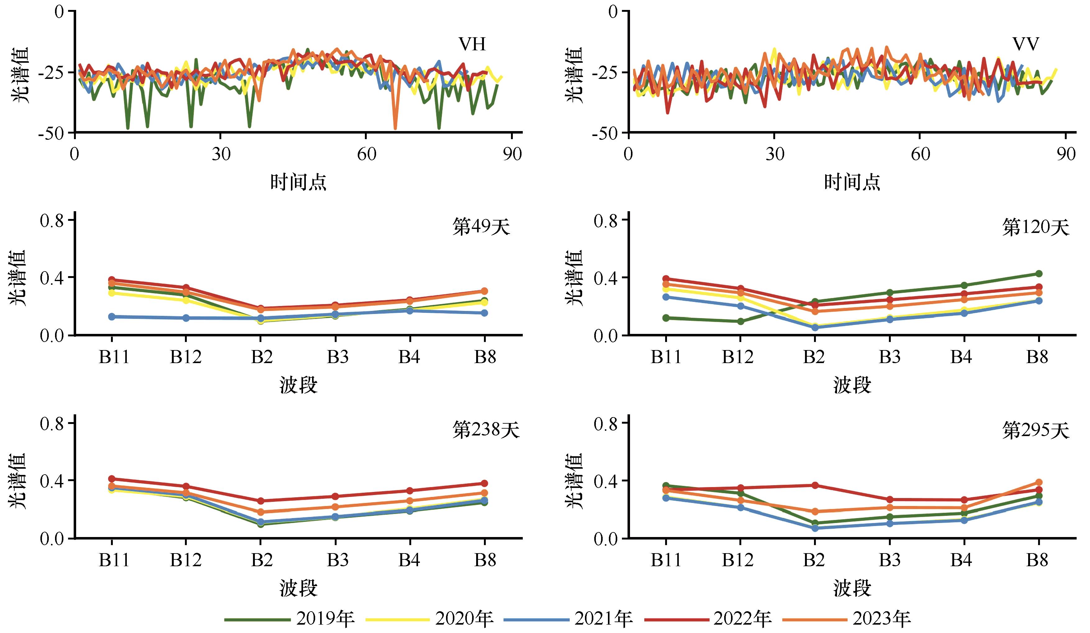
|
| 7 |
Fluet-Chouinard E, Stocker B D, Zhang Z,et al.Extensive global wetland loss over the past three centuries[J].Nature,2023,614(7947):281-286.
|
| 8 |
万洪秀,孙占东,王润.博斯腾湖湿地生态脆弱性评价研究[J].干旱区地理,2006(2):248-254.
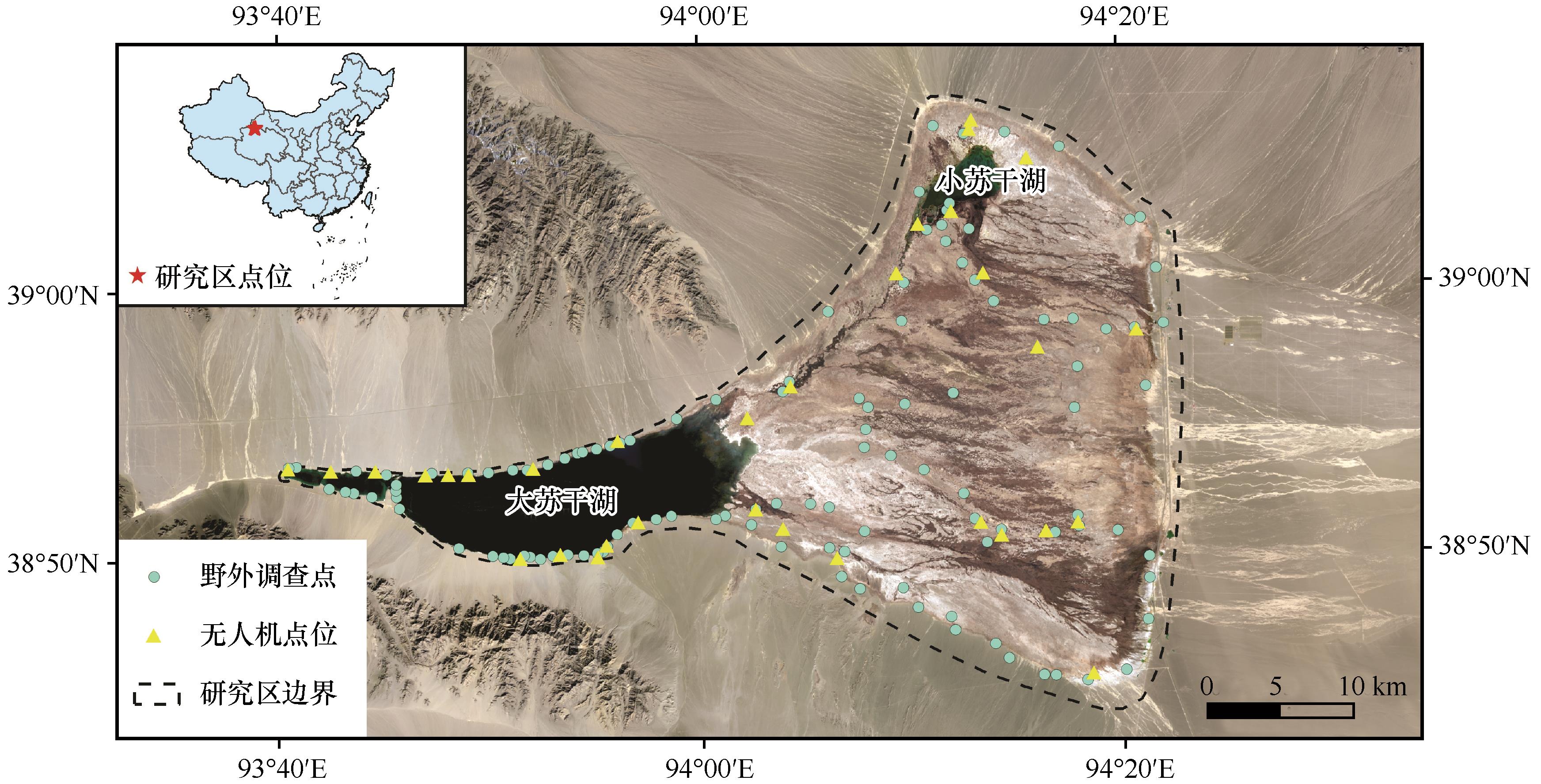
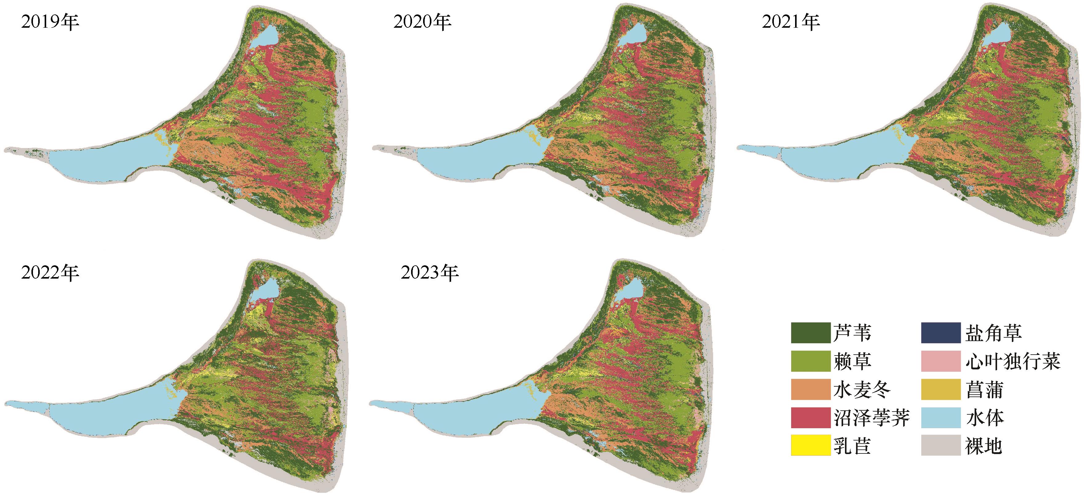
|
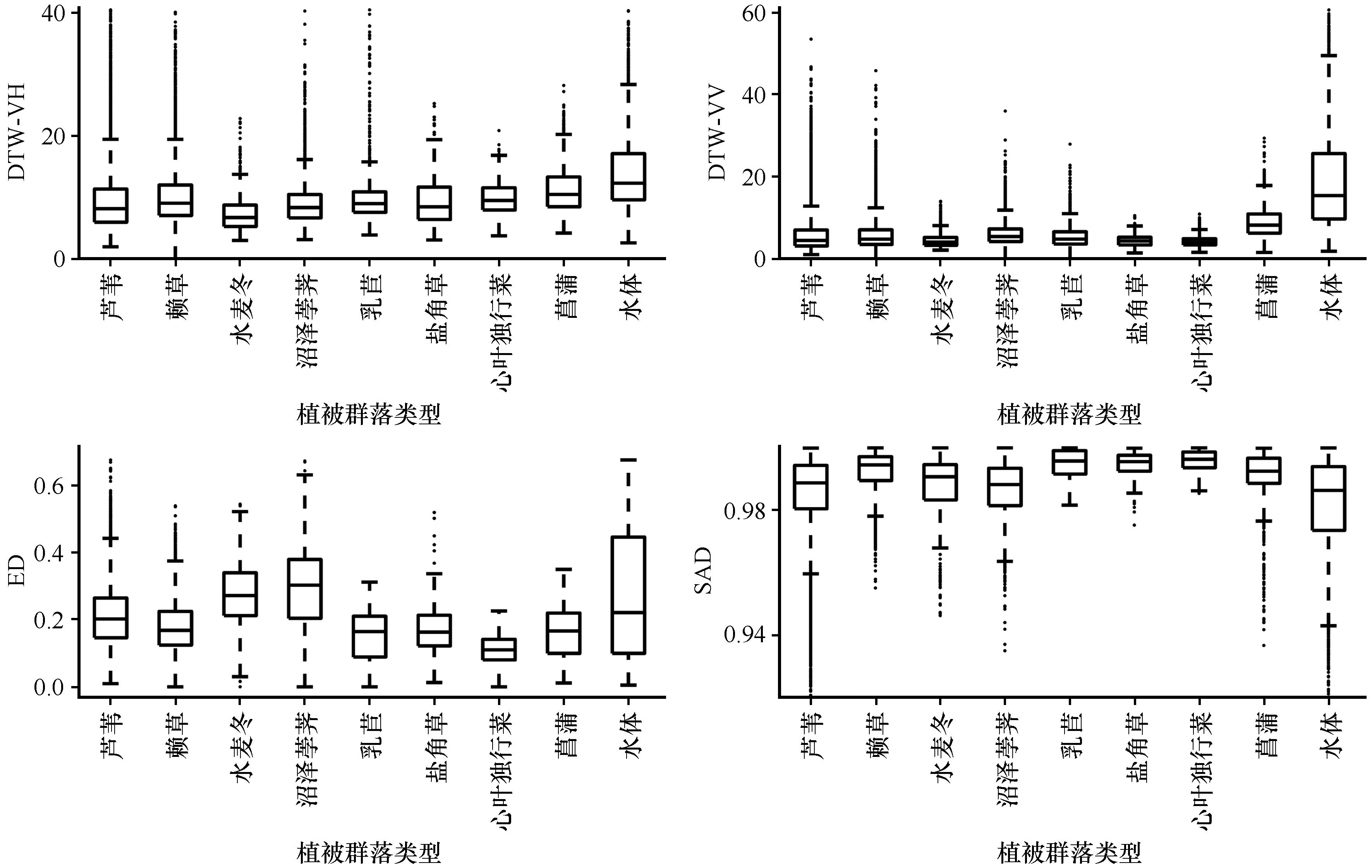
| 9 |
徐贺年,王江林,彭小梅,等.青藏高原东北部祁连圆柏径向生长对不同类型干旱的响应[J].应用生态学报,2022,33:2097-2104.
|
| 10 |
Li C, Fu B, Wang S,et al.Drivers and impacts of changes in China's drylands[J].Nature Reviews Earth & Environment,2021,2(12):858-873.
|
| 11 |
Guo M, Li J, Sheng C,et al.A Review of Wetland Remote Sensing[J].Sensors (Basel),2017,17(4):777.
|
| 12 |
郝斌飞,韩旭军,马明国,等.Google Earth Engine在地球科学与环境科学中的应用研究进展[J].遥感技术与应用,2018,33(4):600-611.
|
| 13 |
芦瑞杰,刘树林,康文平,等.结合GEE平台与机器学习算法的荒漠信息提取[J].中国沙漠,2023,43(6):60-70.
|
| 14 |
李森,颜长珍.基于ChinaCover数据集的绿洲结构数据制图:以河西内陆河流域为例[J].中国沙漠,2023,43(3):230-242.
|
| 15 |
Li Y, Hou Z, Zhang L,et al.Long-term spatio-temporal changes of wetlands in Tibetan Plateau and their response to climate change[J].International Journal of Applied Earth Observation and Geoinformation,2023,121:103351.
|
| 16 |
Geant C B, Gustave M N, Schmitz S.Mapping small inland wetlands in the South-Kivu province by integrating optical and SAR data with statistical models for accurate distribution assessment[J].Scientific Reports,2023,13(1):17626.
|
| 17 |
姚杰鹏,杨磊库,陈探,等.基于Sentinel-1,2和Landsat 8时序影像的鄱阳湖湿地连续变化监测研究[J].遥感技术与应用,2021,36(4):760-776.
|
| 18 |
Chen J, Zhang Z.An improved fusion of Landsat-7/8,Sentinel-2,and Sentinel-1 data for monitoring alfalfa:implications for crop remote sensing[J].International Journal of Applied Earth Observation and Geoinformation,2023,124:103533.
|
| 19 |
Blickensdörfer L, Oehmichen K, Pflugmacher D,et al.National tree species mapping using Sentinel-1/2 time series and German National Forest Inventory data[J].Remote Sensing of Environment,2024,304:114069.
|
| 20 |
程天亮,王新平,马雄忠,等.基于无人机影像的阿拉善东南部荒漠灌丛植被空间格局研究[J].生态学报,2022,42(16):6778-6789.
|
| 21 |
江维薇,李文涛,肖衡林.澜沧江流域糯扎渡水库消落带植被的物种组成、空间分布特征及地形解释[J].湖泊科学,2022,34(6):2025-2039.
|
| 22 |
Huang H, Wang J, Liu C,et al.The migration of training samples towards dynamic global land cover mapping[J].ISPRS Journal of Photogrammetry and Remote Sensing,2020,161:27-36.
|
| 23 |
赵夏纬.苏干湖盆地湿地植被时空分布特征及其成因分析[D].兰州:西北师范大学,2021.
|
| 24 |
Keogh E, Ratanamahatana C A.Exact indexing of dynamic time warping[J].Knowledge and Information Systems,2005,7(3):358-386.
|
| 25 |
Ji L, Geng X, Sun K,et al.Target detection method for water mapping using Landsat 8 OLI/TIRS Imagery[J].Water,2015,7(12):794-817.
|
| 26 |
王奕森,夏树涛.集成学习之随机森林算法综述[J].信息通信技术,2018,12(1):49-55.
|
| 27 |
明義森,刘启航,柏荷,等.利用光学和SAR遥感数据的若尔盖湿地植被分类与变化监测[J].遥感学报,2023,27(6):1414-1425.
|
| 28 |
Balling J, Herold M, Reiche J.How textural features can improve SAR-based tropical forest disturbance mapping[J].International Journal of Applied Earth Observation and Geoinformation,2023,124:103492.
|
| 29 |
Qian H, Bao N, Meng D,et al.Mapping and classification of Liao River Delta coastal wetland based on time series and multi-source GaoFen images using stacking ensemble model[J].Ecological Informatics,2024,80:102488.
|
| 30 |
Peng K, Jiang W, Hou P,et al.Continental-scale wetland mapping:a novel algorithm for detailed wetland types classification based on time series Sentinel-1/2 images[J].Ecological Indicators,2023,148:110113.
|
| 31 |
Nedkov R.Orthogonal transformation of segmented images from the satellite Sentinel-2[J].Comptes rendus de l'Academie bulgare des Sciences,2017,70(5):687-692.
|
| 32 |
Dong T, Liu J, Shang J,et al.Assessment of red-edge vegetation indices for crop leaf area index estimation[J].Remote Sensing of Environment,2019,222:133-143.
|
| 33 |
Shen X, Shen M, Wu C,et al.Critical role of water conditions in the responses of autumn phenology of marsh wetlands to climate change on the Tibetan Plateau[J].Global Change Biology,2024,30(1):e17097.
|
| 34 |
康满萍,赵成章,白雪,等.苏干湖湿地植被覆盖度时空变化格局[J].生态学报,2020,40(9):2975-2984.
|
| 35 |
李平平,王晓丹,陈海龙.苏干湖湿地与奎屯诺尔湿地之间水力联系研究[J].干旱区研究,2022,39(2):429-435.
|
| 36 |
王德旺,何萍,张馨予,等.苏干湖流域冰川、湿地对气候变化的响应研究[J].干旱区资源与环境,2023,37(8):107-116.
|
| 37 |
Yang Y, Wu J, Miao Y,et al.Lake changes during the past five decades in Central East Asia:links with climate change and climate future forecasting[J].Water,2022,14(22):3661.
|
| 38 |
康满萍,赵成章,李群.苏干湖湿地土壤全盐含量特征及其与地下水的关联[J].生态学报,2022,42(22):9026-9034.
|
| 39 |
Zhang M, Delgado-Baquerizo M, Li G,et al.Experimental impacts of grazing on grassland biodiversity and function are explained by aridity[J].Nature Communications,2023,14(1):5040.
|
| 40 |
施雅风,沈永平,胡汝骥.西北气候由暖干向暖湿转型的信号、影响和前景初步探讨[J].冰川冻土,2002,24(3):219-226.
|
| 41 |
陈发虎,谢亭亭,杨钰杰,等.我国西北干旱区“暖湿化”问题及其未来趋势讨论[J].中国科学:地球科学,2023,53(6):1246-1262.
|
 ), 苗运法1,2(
 甘公网安备 62010202000688号