中国沙漠 ›› 2026, Vol. 46 ›› Issue (4): 120-134.DOI: 10.7522/j.issn.1000-694X.2025.00284
周畅( ), 杨林海()
收稿日期:2025-06-03
修回日期:2025-12-01
出版日期:2026-07-20
发布日期:2026-08-27
通讯作者:
杨林海
作者简介:周畅(1999—),男,安徽六安人,硕士研究生,主要从事风沙地貌研究。E-mail: zhouchang910@snnu.edu.cn
基金资助:
Chang Zhou(), Linhai Yang()
Received:2025-06-03
Revised:2025-12-01
Online:2026-07-20
Published:2026-08-27
Contact:
Linhai Yang
摘要:
雅鲁藏布江(简称雅江)河谷作为全球高海拔河流-风沙系统分布区,风沙地貌普遍发育且十分典型,其中以发育在谷坡上的爬坡沙丘最具特色。爬坡沙丘是雅江流域荒漠化景观的重要构成单元,过去相关研究主要在爬坡沙丘的分布与形态、物质组成、动力学及流场特征等方面,对于其物质来源及其与水沙等其他物源的迁移转化过程和较长时间尺度的形成演化过程的研究还比较薄弱。系统的年代学工作是研究沙漠、沙地演化过程以及正确认识沙丘形成发育气候背景的基础。目前雅江流域风成沙的年代数据主要集中在30 ka BP以来,特别是13 ka BP以来,之前的风沙记录存在缺失。雅江流域爬坡沙丘的形成及其演化机制是今后的研究重点,其中,利用有效的钻孔取芯技术,选择多个地点的爬坡沙丘,在其延伸方向和垂直堆积方向上获取高分辨率的年代数据和沉积物指标数据,是重建其形成演化历史的关键。
中图分类号:
周畅, 杨林海. 雅鲁藏布江河谷爬坡沙丘研究进展[J]. 中国沙漠, 2026, 46(4): 120-134.
Chang Zhou, Linhai Yang. Research progress on climbing dunes in the Yarlung Zangbo River Valley, southern Tibetan Plateau[J]. Journal of Desert Research, 2026, 46(4): 120-134.
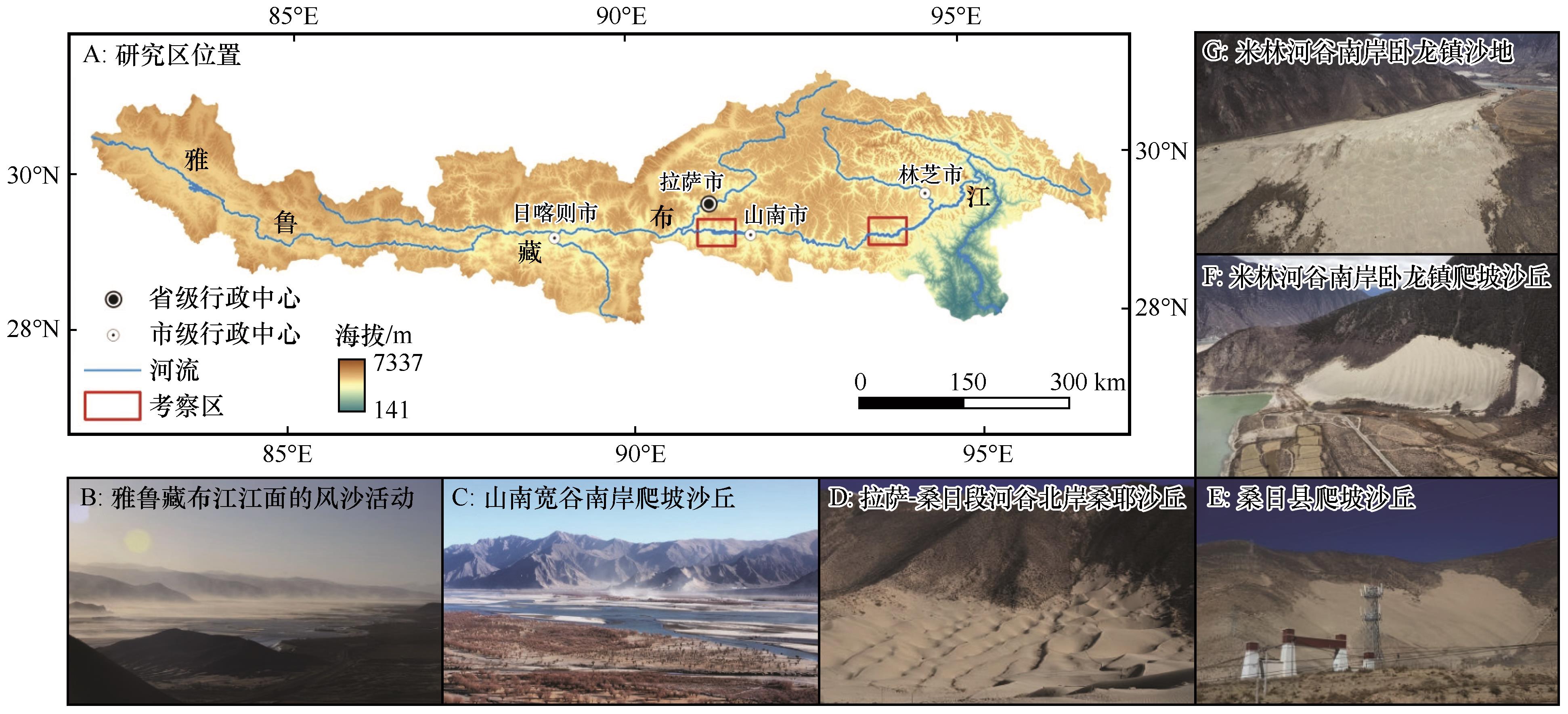
图1 研究区位置及雅鲁藏布江河谷内的风沙地貌景观
Fig.1 The location of research area and aeolian landforms in Yarlung Zangbo River Valley
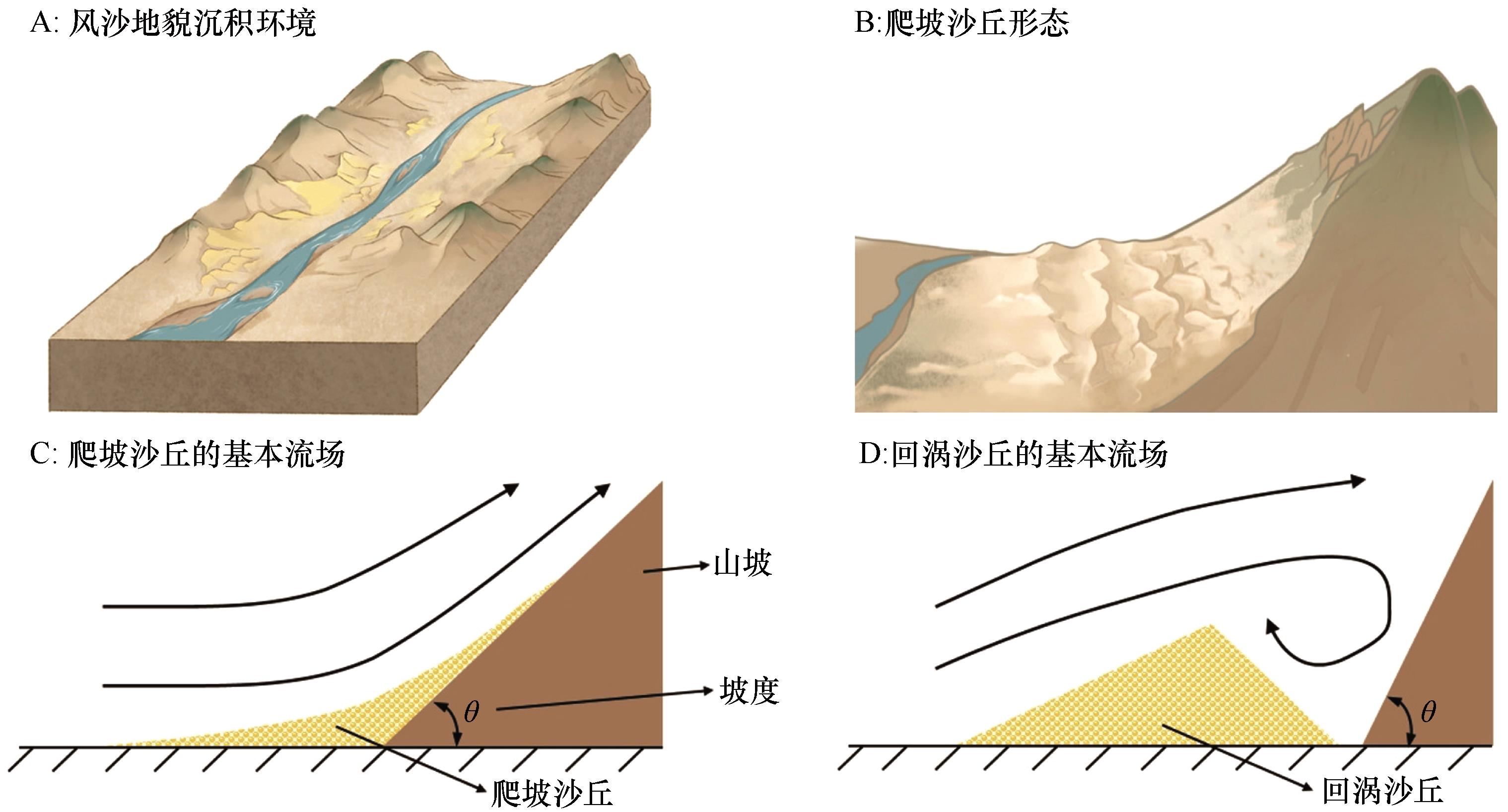
图2 雅鲁藏布江河谷爬坡沙丘形态及形成机制示意图
Fig.2 Schematic diagram of the morphology and formation mechanism of climbing dunes in Yarlung Zangbo River Valley
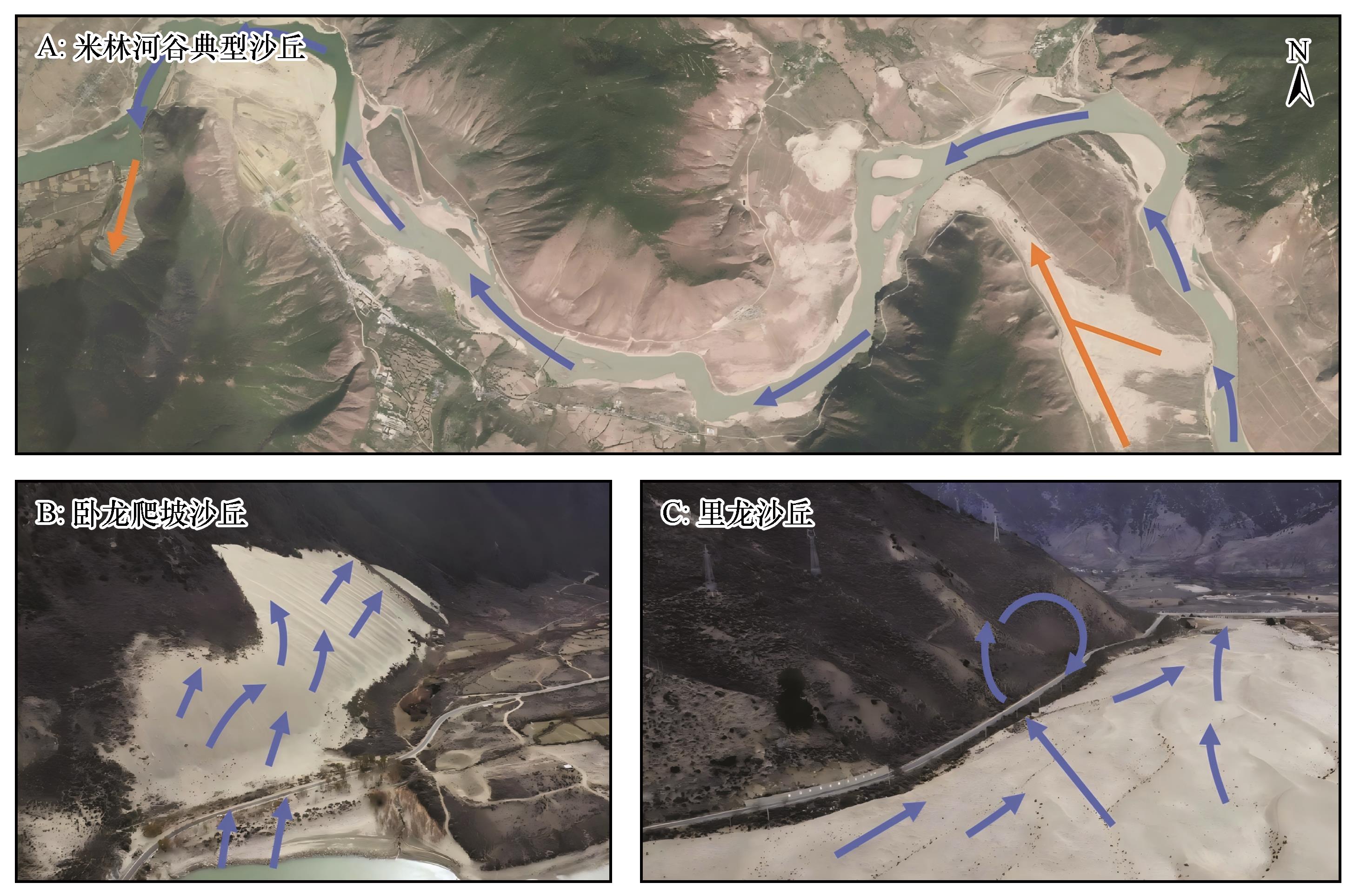
图3 雅鲁藏布江河谷米林段的典型沙丘注:橙色箭头为河谷内风成物质运移方向,蓝色箭头代表近地表气流
Fig.3 Typical aeolian dunes in the Mainling valley of Yarlung Zangbo River
| 编号 | 剖面/样品 | 地理坐标 | 海拔/m | 地貌部位 | 深度/cm | 年代/ka BP | 测年方法 | 参考文献 |
|---|---|---|---|---|---|---|---|---|
| 1 | SRP | 29°15′N,91°59′E | 3 553 | 河谷山麓 | 70 | 0.4±0.1 | OSL | [ |
| 2 | 140 | 0.8±0.1 | ||||||
| 3 | 210 | 1.0±0.1 | ||||||
| 4 | 280 | 1.1±0.1 | ||||||
| 5 | 350 | 1.0±0.1 | ||||||
| 6 | 420 | 1.2±0.1 | ||||||
| 7 | 490 | 4.1±0.4 | ||||||
| 8 | MLP | 29°07′N,93°46′E | 3 004 | 河谷山麓 | 650 | 4.5±0.3 | ||
| 9 | 1 000 | 6.2±0.5 | ||||||
| 10 | JJ | 28°32′N,87°49′E | 4 063 | 山前坡地 | 26 | 0.2±0.11 | OSL | [ |
| 11 | 170 | 3.7±0.51 | ||||||
| 12 | XL | 28°21′N,87°41′E | 4 060 | 河流阶地 | 22 | 0.4±0.05 | ||
| 13 | 164 | 2.4±0.2 | ||||||
| 14 | 248 | 7.5±0.28 | ||||||
| 15 | 江塘剖面 | 29°18′N,90°41'E | 3 600 | 河流阶地 | 125 | 5.57±0.13 | 14C | [ |
| 16 | 209 | 7.83±0.13 | ||||||
| 17 | 泽当剖面 | 29°14′N,91°42′E | 3 561 | 河流阶地 | 630 | 8.5±0.6 | OSL | [ |
| 18 | Cha'er | 29°23′N,89°17′E | 3 856 | 河流阶地 | 65 | 2.23±0.1 | 14C | [ |
| 19 | 363 | 8.56±0.7 | TL | |||||
| 20 | ZD20 | 29°14′N,91°42′E | 3 559 | 河谷山麓 | 30 | 1.22±0.08 | OSL | [ |
| 21 | 80 | 2.21±0.19 | ||||||
| 22 | 400 | 7.67±0.40 | ||||||
| 23 | 450 | 7.95±0.63 | ||||||
| 24 | 500 | 8.44±0.51 | ||||||
| 25 | 550 | 8.60±0.47 | ||||||
| 26 | 600 | 9.04±0.65 | ||||||
| 27 | 680 | 9.24±0.47 | ||||||
| 28 | 730 | 9.85±0.62 | ||||||
| 29 | 780 | 10.35±0.94 | ||||||
| 30 | 830 | 10.62±0.70 | ||||||
| 31 | 880 | 11.35±0.79 | ||||||
| 32 | Pala | 28°18′N,87°25′E | 4 325 | 下沉高地 | 80 | 8.6±0.9 | OSL | [ |
| 33 | 170 | 11.0±1.2 | ||||||
| 34 | 260 | 11.0±1.5 | ||||||
| 35 | ZZ | 29°52′N,83°47′E | 4 720 | 河谷山麓 | 70 | 0.21±0.08 | OSL | [ |
| 36 | 240 | 4.6±0.89 | ||||||
| 37 | 300 | 23.9±5.4 | ||||||
| 38 | Section59 | 30°08′N,95°30′E | 3 070 | 低山山麓 | 29 | 25.5±4.0 | TL | [ |
| 39 | STA-1 | 29°38′N,91°06′E | 3 658 | 河谷山麓 | 50 | 2.9±0.2 | OSL | [ |
| 40 | 180 | 4.1±0.4 | ||||||
| 41 | 280 | 6.7±0.5 | ||||||
| 42 | QUX1 | 29°21′N,90°43′E | 3 603 | 河谷山麓 | 280 | 8.5±0.7 | ||
| 43 | QUX2 | 29°21′N,90°45′E | 3 536 | 河流阶地 | 130 | 17.2±1.4 | ||
| 44 | CHI1 | 29°22′N,90°54′E | 3 820 | 山前坡地 | 70 | 14.4±1.1 | ||
| 45 | 300 | 19.8±1.9 | ||||||
| 46 | 650 | 23.9±2.1 | ||||||
| 47 | 1000 | 21.3±1.8 | ||||||
| 48 | JIN2 | 29°26′N,90°54′E | 3 597 | 河谷山麓 | 130 | 7.7±0.8 | ||
| 49 | 250 | 14.3±1.6 | ||||||
| 50 | 340 | 18.8±2.0 | ||||||
| 51 | DRE18 | 29°40′N,91°03′E | 3 707 | 河谷山麓 | 330 | 32.3±3.2 | ||
| 52 | MOG4 | 29°47′N,91°49′E | 3 894 | 河谷山麓 | 130 | 28.2±3.1 | ||
| 53 | 350 | 81±7 | ||||||
| 54 | 米林卧龙 | 29°08′N,93°40′E | — | 山前坡地 | — | 29±3 | TL | [ |
| 55 | 贡嘎多基扎 | 29°21′N,91°05′E | — | 山前坡地 | — | 48.7±2.4 | ||
| 56 | SY | 29°16′N,91°28′E | 3 568 | — | 340 | 7.93±0.39 | OSL | [ |
| 57 | 410 | 10.23±0.64 | ||||||
| 58 | 480 | 11.17±0.67 | ||||||
| 59 | 530 | 10.63±0.68 | ||||||
| 60 | HZ | 29°17′N,91°03′E | 3 580 | 河流阶地 | 300 | 9.64±0.50 | OSL | [ |
| 61 | 325 | 9.69±0.57 |
表1 已发表的雅鲁藏布江流域风成沙年代数据
Table 1 Published ages for aeolian sands in the Yarlung Zangbo River Valley
| 编号 | 剖面/样品 | 地理坐标 | 海拔/m | 地貌部位 | 深度/cm | 年代/ka BP | 测年方法 | 参考文献 |
|---|---|---|---|---|---|---|---|---|
| 1 | SRP | 29°15′N,91°59′E | 3 553 | 河谷山麓 | 70 | 0.4±0.1 | OSL | [ |
| 2 | 140 | 0.8±0.1 | ||||||
| 3 | 210 | 1.0±0.1 | ||||||
| 4 | 280 | 1.1±0.1 | ||||||
| 5 | 350 | 1.0±0.1 | ||||||
| 6 | 420 | 1.2±0.1 | ||||||
| 7 | 490 | 4.1±0.4 | ||||||
| 8 | MLP | 29°07′N,93°46′E | 3 004 | 河谷山麓 | 650 | 4.5±0.3 | ||
| 9 | 1 000 | 6.2±0.5 | ||||||
| 10 | JJ | 28°32′N,87°49′E | 4 063 | 山前坡地 | 26 | 0.2±0.11 | OSL | [ |
| 11 | 170 | 3.7±0.51 | ||||||
| 12 | XL | 28°21′N,87°41′E | 4 060 | 河流阶地 | 22 | 0.4±0.05 | ||
| 13 | 164 | 2.4±0.2 | ||||||
| 14 | 248 | 7.5±0.28 | ||||||
| 15 | 江塘剖面 | 29°18′N,90°41'E | 3 600 | 河流阶地 | 125 | 5.57±0.13 | 14C | [ |
| 16 | 209 | 7.83±0.13 | ||||||
| 17 | 泽当剖面 | 29°14′N,91°42′E | 3 561 | 河流阶地 | 630 | 8.5±0.6 | OSL | [ |
| 18 | Cha'er | 29°23′N,89°17′E | 3 856 | 河流阶地 | 65 | 2.23±0.1 | 14C | [ |
| 19 | 363 | 8.56±0.7 | TL | |||||
| 20 | ZD20 | 29°14′N,91°42′E | 3 559 | 河谷山麓 | 30 | 1.22±0.08 | OSL | [ |
| 21 | 80 | 2.21±0.19 | ||||||
| 22 | 400 | 7.67±0.40 | ||||||
| 23 | 450 | 7.95±0.63 | ||||||
| 24 | 500 | 8.44±0.51 | ||||||
| 25 | 550 | 8.60±0.47 | ||||||
| 26 | 600 | 9.04±0.65 | ||||||
| 27 | 680 | 9.24±0.47 | ||||||
| 28 | 730 | 9.85±0.62 | ||||||
| 29 | 780 | 10.35±0.94 | ||||||
| 30 | 830 | 10.62±0.70 | ||||||
| 31 | 880 | 11.35±0.79 | ||||||
| 32 | Pala | 28°18′N,87°25′E | 4 325 | 下沉高地 | 80 | 8.6±0.9 | OSL | [ |
| 33 | 170 | 11.0±1.2 | ||||||
| 34 | 260 | 11.0±1.5 | ||||||
| 35 | ZZ | 29°52′N,83°47′E | 4 720 | 河谷山麓 | 70 | 0.21±0.08 | OSL | [ |
| 36 | 240 | 4.6±0.89 | ||||||
| 37 | 300 | 23.9±5.4 | ||||||
| 38 | Section59 | 30°08′N,95°30′E | 3 070 | 低山山麓 | 29 | 25.5±4.0 | TL | [ |
| 39 | STA-1 | 29°38′N,91°06′E | 3 658 | 河谷山麓 | 50 | 2.9±0.2 | OSL | [ |
| 40 | 180 | 4.1±0.4 | ||||||
| 41 | 280 | 6.7±0.5 | ||||||
| 42 | QUX1 | 29°21′N,90°43′E | 3 603 | 河谷山麓 | 280 | 8.5±0.7 | ||
| 43 | QUX2 | 29°21′N,90°45′E | 3 536 | 河流阶地 | 130 | 17.2±1.4 | ||
| 44 | CHI1 | 29°22′N,90°54′E | 3 820 | 山前坡地 | 70 | 14.4±1.1 | ||
| 45 | 300 | 19.8±1.9 | ||||||
| 46 | 650 | 23.9±2.1 | ||||||
| 47 | 1000 | 21.3±1.8 | ||||||
| 48 | JIN2 | 29°26′N,90°54′E | 3 597 | 河谷山麓 | 130 | 7.7±0.8 | ||
| 49 | 250 | 14.3±1.6 | ||||||
| 50 | 340 | 18.8±2.0 | ||||||
| 51 | DRE18 | 29°40′N,91°03′E | 3 707 | 河谷山麓 | 330 | 32.3±3.2 | ||
| 52 | MOG4 | 29°47′N,91°49′E | 3 894 | 河谷山麓 | 130 | 28.2±3.1 | ||
| 53 | 350 | 81±7 | ||||||
| 54 | 米林卧龙 | 29°08′N,93°40′E | — | 山前坡地 | — | 29±3 | TL | [ |
| 55 | 贡嘎多基扎 | 29°21′N,91°05′E | — | 山前坡地 | — | 48.7±2.4 | ||
| 56 | SY | 29°16′N,91°28′E | 3 568 | — | 340 | 7.93±0.39 | OSL | [ |
| 57 | 410 | 10.23±0.64 | ||||||
| 58 | 480 | 11.17±0.67 | ||||||
| 59 | 530 | 10.63±0.68 | ||||||
| 60 | HZ | 29°17′N,91°03′E | 3 580 | 河流阶地 | 300 | 9.64±0.50 | OSL | [ |
| 61 | 325 | 9.69±0.57 |
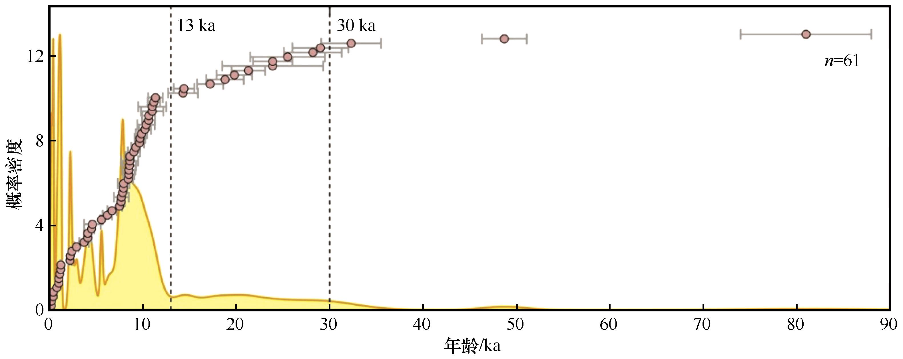
图4 雅鲁藏布江流域风成沙年代概率密度曲线(数据来自于表1中的参考文献)
Fig.4 Probability density of ages from aeolian sands of Yarlung Zangbo River Valley
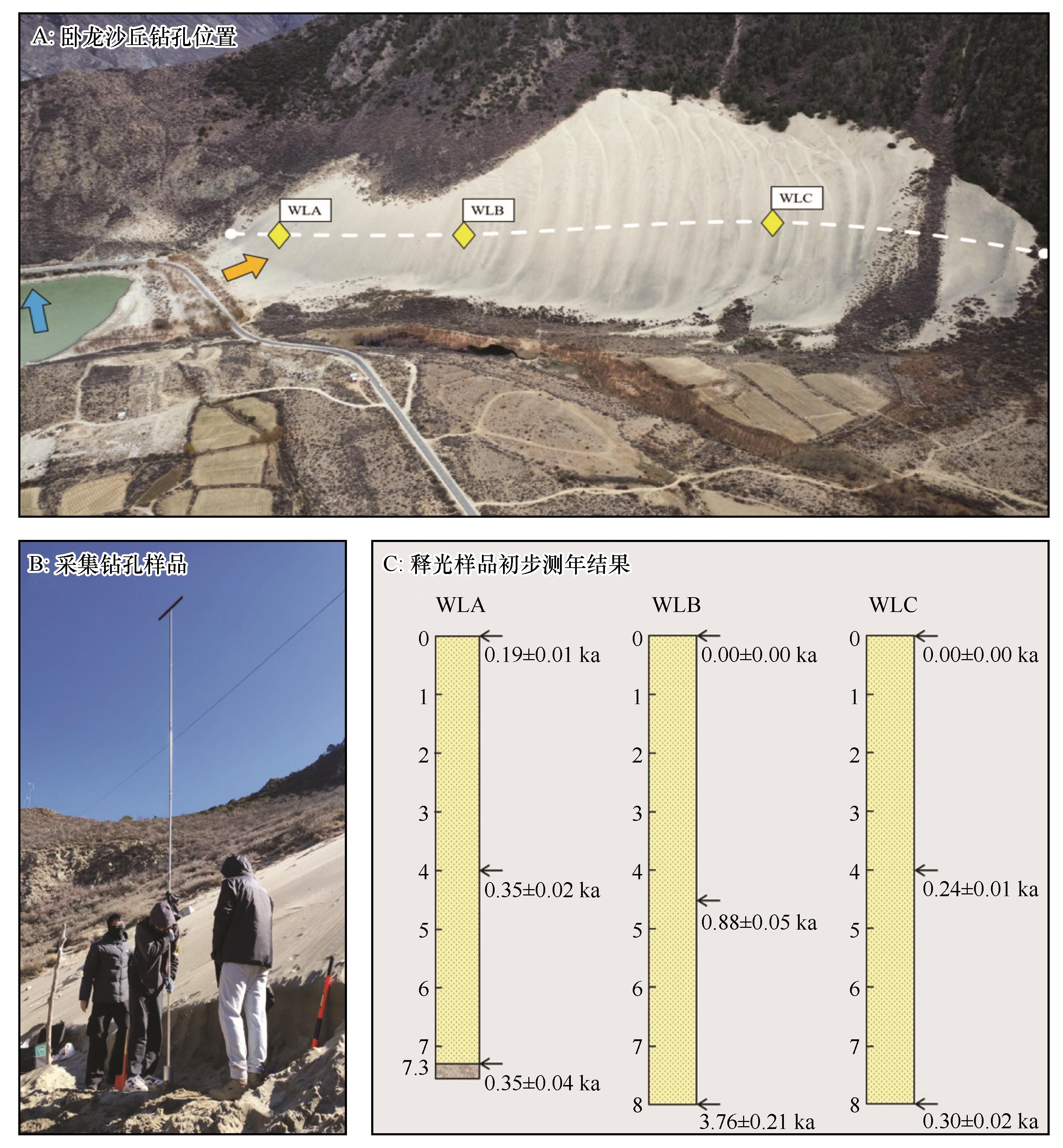
图5 雅鲁藏布江河谷米林段卧龙爬坡沙丘钻孔采样及初步测年结果注:图A中蓝色和橙色箭头分别指向河流流向和近地表风向;图C中黄色代表风成沙,深灰色代表基岩
Fig.5 Borehole sampling in Wolong climbing dune and preliminary dating results
| [1] | 董治宝,等.青藏高原风沙地貌图集[M].西安:西安地图出版社,2017. |
| [2] | Dong Z B, Hu G Y, Qian G Q,et al.High-altitude aeolian research on the Tibetan Plateau[J].Reviews of Geophysics,2017,55(4):864-901. |
| [3] | Kaiser K, Lai Z P, Schneider B,et al.Stratigraphy and palaeoenvironmental implications of Pleistocene and Holocene aeolian sediments in the Lhasa area,southern Tibet (China)[J].Palaeogeography Palaeoclimatology Palaeoecology,2009,271(3/4):329-342. |
| [4] | 李森,王跃,哈斯,等.雅鲁藏布江河谷风沙地貌分类与发育问题[J].中国沙漠,1997,17(4):10-18. |
| [5] | Zhang C L, Li Q, Shen Y P,et al.Monitoring of aeolian desertification on the Qinghai-Tibet Plateau from the 1970s to 2015 using Landsat images[J].Science of the Total Environment,2018,619:1648-1659. |
| [6] | Dong M, Yan P, Liu B L,et al.Distribution patterns and morphological classification of climbing dunes in the Qinghai-Tibet Plateau[J].Aeolian Research,2018,35:58-68. |
| [7] | 董苗,严平,王晓旭,等.共和盆地多石在沟爬坡沙丘沉积物特征及环境意义[J].干旱区资源与环境,2022,36(5):79-86. |
| [8] | Hack J T.Dunes of the Western Navajo Country[J].Geographical Review,1941,31(2):240-263. |
| [9] | Pye K, Tsoar H.Aeolian Sand and Sand Dunes[M].London,UK:Unwin Hyman,1990:89-93. |
| [10] | Tsoar H.Wind tunnel modeling of echo and climbing dunes[J].Developments in Sedimentology,1983,38:247-259. |
| [11] | 钱广强,董治宝,罗万银,等.不同坡度障碍物前气流场特征及其对回涡沙丘形成的影响[J].中国科学:地球科学,2012,42(1):34-41. |
| [12] | Dluzewski M, Rotnicka J, Hesp P A,et al.Airflow dynamics and aeolian sand transport across a beach-climbing dune-clifftop dune system[J].Journal of Geophysical Research-Earth Surface,2023,128(11):JF007316. |
| [13] | Jackson D W T, Cooper J G, Green A N.A preliminary classification of coastal sand dunes of KwaZulu-Natal[J].Journal of Coastal Research,2014:718-722. |
| [14] | Blight G B, Blight J, Blight G F.South Africa's mountain-climbing sand dunes mechanism of formation and present status[J].Journal of the South African Institution of Civil Engineering,2013(8):11-19. |
| [15] | Li S, Liu X W, Li H C,et al.A wind tunnel simulation of the dynamic processes involved in sand dune formation on the western coast of Hainan Island[J].Journal of Geographical Sciences,2007,17(4):453-468. |
| [16] | Ferraz M, Cowell P, Rebêlo L.Coastal-change estimates inferred from remnant cliff-top dunes[J].Journal of Coastal Research,2011,64(SI):661-665. |
| [17] | Arce-Chamorro C, Vidal-Romaní J R, Sanjurjo-Sánchez J.Chronology of four climbing dune outcrops on the Atlantic Coast of Galicia (NW Spain) Linked to the sea level fall during the MIS6 and MIS4 isotopic stages[J].Journal of Marine Science and Engineering,2022,10(3):312. |
| [18] | Howard A.Interaction of sand transport with topography with local winds in the northern Peruvian coastal desert[C]//Barndorff-Nielsen O E.International Workshop on the Physics of Blown Sand.Commonwealth of Virginia,USA:University of Virginia,1985(8):511-544. |
| [19] | Evans J R.Falling and climbing sand dunes in the Cronese (“Cat”) Mountain Area,San Bernardino County,California[J].Journal of Geology,1962,70(1):107-113. |
| [20] | Lancaster N, Tchakerian V P.Geomorphology and sediments of sand ramps in the Mojave Desert[J].Geomorphology,1996,17(1):151-165. |
| [21] | Bateman M D, Bryant R G, Foster I D L,et al.On the formation of sand ramps:a case study from the Mojave Desert[J].Geomorphology,2012,161:93-109. |
| [22] | White B R, Tsoar H.Slope effect on saltation over a climbing sand dune[J].Geomorphology,1998,22(2):159-180. |
| [23] | 李森,董光荣,申建友,等.雅鲁藏布江河谷风沙地貌形成机制与发育模式[J].中国科学(D辑:地球科学),1999(1):88-96. |
| [24] | Dong M, Yan P, Wang X X,et al.Morphological characteristics and dynamic changes of typical climbing dunes on the Qinghai-Tibet Plateau[J].Geomorphology,2023,440:108869. |
| [25] | Chojnacki M, Moersch J E, Burr D M.Climbing and falling dunes in Valles Marineris,Mars[J].Geophysical Research Letters,2010,37:L08201. |
| [26] | Wang B N, Gong J F, Zuza A V,et al.Aeolian sand dunes alongside the Yarlung River in southern Tibet:a provenance perspective[J].Geological Journal,2021,56(5):2625-2536. |
| [27] | 杨逸畴.雅鲁藏布江河谷风沙地貌的初步观察[J].中国沙漠,1984,4(3):16-19. |
| [28] | Zhang J Q, Zhang C L, Li Q,et al.Grain-size distribution of surface sediments of climbing and falling dunes in the Zedang valley of the Yarlung Zangbo River,southern Tibetan Plateau[J].Journal Of Earth System Science,2019,128(1):11. |
| [29] | Na Z, Qing L, Zhang C L,et al.Grain size characteristics of aeolian sands and their implications for the aeolian dynamics of dunefields within a river valley on the southern Tibet Plateau:a case study from the Yarlung Zangbo River Valley[J].Catena,2021,196:104794. |
| [30] | 周娜,张春来,刘永刚.雅鲁藏布江米林宽谷段爬升沙丘粒度分异特征研究[J].地理研究,2012,31(1):82-94. |
| [31] | Liang W D, Hu X M, Garzanti E,et al.Fluvial-aeolian interaction and compositional variability in the river-fed Yarlung Tsangpo dune system (southern Tibet)[J].Journal Of Geophysical Research-Earth Surface,2023,128(5):JF006920. |
| [32] | Ling Z Y, Li J S, Jin J H,et al.Geochemical characteristics and provenance of aeolian sediments in the Yarlung Tsangpo Valley,southern Tibetan Plateau[J].Environmental Earth Sciences,2021,80(18):623. |
| [33] | 杨军怀,夏敦胜,高福元,等.雅鲁藏布江流域风成沉积研究进展[J].地球科学进展,2020,35(8):863-877. |
| [34] | 马晓莉,李顺,岳雅慧.基于碎屑锆石特征的雅鲁藏布江山南宽谷风成沙丘物源示踪[J].第四纪研究,2023,43(5):1157-1171. |
| [35] | 张正偲,张焱,马鹏飞,等.雅鲁藏布江中游风沙区典型下垫面空气动力学参数研究[J].干旱区研究,2022,39(4):997-1005. |
| [36] | 刘婷,贾晓鹏,陈定梅,等.雅鲁藏布江中游平坦流沙地表空气动力学特征[J].中国沙漠,2023,43(5):194-203. |
| [37] | 靳鹤龄,董光荣,刘玉璋,等.0.8 Ma B.P.以来西藏雅鲁藏布江中游地区沙地演化和气候变化[J].中国沙漠,1998,18(2):2-9. |
| [38] | 聂宁,张万昌,邓财.雅鲁藏布江流域1978-2009年气候时空变化及未来趋势研究[J].冰川冻土,2012,34(1):64-71. |
| [39] | Yao T D, Li Z G, Yang W,et al.Glacial distribution and mass balance in the Yarlung Zangbo River and its influence on lakes[J].Chinese Science Bulletin,2010,55(20):2072-2078. |
| [40] | Hou J Z, D'andrea W J, Wang M D,et al.Influence of the Indian monsoon and the subtropical jet on climate change on the Tibetan Plateau since the late Pleistocene[J].Quaternary Science Reviews,2017,163:84-94 |
| [41] | 杨逸畴,李炳元,尹泽生,等.西藏高原地貌的形成和演化[J].地理学报,1982(1):76-87. |
| [42] | Zhu S, Wu Z H, Zhao X T,et al.Ages and genesis of terrace flights in the middle reaches of the Yarlung Zangbo River,Tibetan Plateau,China[J].Boreas,2014,43(2):485-504. |
| [43] | 詹琪琪,赵伟,杨梦娇,等.雅鲁藏布江中部流域土地沙化遥感识别[J].地球信息科学学报,2022,24(2):391-404. |
| [44] | 李永霞,方江平.西藏雅鲁藏布江中游地区土地沙化面积变化分析[J].贵州农业科学,2011,39(12):71-74. |
| [45] | 孙明,沈渭寿,李海东,等.雅鲁藏布江源区风沙化土地演变趋势[J].自然资源学报,2010,25(7):1163-1171. |
| [46] | Liu Y, Wang Y S, Shen T.Spatial distribution and formation mechanism of aeolian sand in the middle reaches of the Yarlung Zangbo River[J].Journal of Mountain Science,2019,16(9):1987-2000. |
| [47] | Rowell A, Thomas D, Bailey R,et al.Controls on sand ramp formation in southern Namibia[J].Earth Surface Processes and Landforms,2018,43(1):150-171. |
| [48] | Zhou N, Zhang C L, Wu X X,et al.The geomorphology and evolution of aeolian landforms within a river valley in a semi-humid environment:a case study from Mainling Valley,Qinghai-Tibet Plateau[J].Geomorphology,2014,224:27-38. |
| [49] | Chojnacki M, Burr D M, Moersch J E.Valles Marineris dune fields as compared with other martian populations:diversity of dune compositions,morphologies,and thermophysical properties[J].Icarus,2014,230:96-142. |
| [50] | Tirsch D, Craddock R A, Platz T,et al.Spectral and petrologic analyses of basaltic sands in Ka'u Desert (Hawaii):implications for the dark dunes on Mars[J].Earth Surface Processes and Landforms,2012,37(4):434-448. |
| [51] | Zhang Z C, Dong Z B.Grain size characteristics in the Hexi Corridor desert[J].Aeolian Research,2015,18:55-67. |
| [52] | 张正偲,董治宝.风沙地貌形态动力学研究进展[J].地球科学进展,2014,29(6):734-747. |
| [53] | 钱广强,董治宝,罗万银,等.横向沙丘背风侧气流重附风洞模拟[J].中国沙漠,2008,28(1):16-20. |
| [54] | 董苗,严平,王晓旭,等.雅鲁藏布江山南宽谷段爬坡沙丘表层沉积物特征[J].中国沙漠,2022,42(2):153-163. |
| [55] | 潘美慧,杨安娜,伍永秋,等.雅江河谷佛掌沙丘表层沉积物粒度特征[J].自然资源学报,2020,35(12):3076-3088. |
| [56] | 董苗,严平,王晓旭,等.青藏高原不同气候带爬坡沙丘沉积物特征及其环境指示[J].地理学报,2023,78(7):1825-1846. |
| [57] | 李小妹,严平,吴伟,等.克里雅河中下游流域地表沉积物的粒度与化学元素空间分布[J].地理科学,2016,36(8):1269-1276. |
| [58] | 田伟东,杨军怀,王树源,等.雅鲁藏布江河谷沙丘沉积物粒度特征及其环境指示[J].干旱区资源与环境,2022,36(1):128-134. |
| [59] | Péwé T L, Liu T S, Slatt R M,et al.Origin and character of loess like silt in the southern Qinghai-Xizang (Tibet) Plateau,China[J].USGS Professional Paper,1995,1549:1-55. |
| [60] | Ling Z Y, Yang X Y, Wang Y X,et al.OSL chronology of the Liena archeological site in the Yarlung Tsangpo Valley throws new light on human occupation of the Tibetan Plateau[J].Holocene,2020,30(7):1043-1052. |
| [61] | Klinge M, Lehmkuhl F.Holocene aeolian mantles and inter-bedded paleosols on the southern Tibetan Plateau[J].Quaternary International,2015,372:33-44. |
| [62] | 杨小平,梁鹏,方伊曼,等.中国沙漠与环境演变[M].北京:科学出版社,2024 |
| [63] | Sun J M, Li S H, Muhs D R,et al.Loess sedimentation in Tibet:provenance,processes,and link with Quaternary glaciations[J].Quaternary Science Reviews,2007,26(17/18):2265-2280. |
| [64] | 马鹏飞,论珠群培,张焱,等.雅鲁藏布江中游江心洲、河漫滩面积及其指示的沙源特征[J].中国沙漠,2021,41(3):25-33. |
| [65] | 张焱,马鹏飞,曾林,等.基于沉积物理化性质的雅鲁藏布江中游粉尘物源研究[J].中国沙漠,2021,41(3):92-100. |
| [66] | 王晓枝,董治宝,南维鸽,等.拉萨河谷爬坡沙丘沉积物特征[J].中国沙漠,2022,42(4):22-31. |
| [67] | Du S S, Wu Y Q, Tan L H,et al.Geochemical characteristics of fine and coarse fractions of sediments in the Yarlung Zangbo River Basin (southern Tibet,China)[J].Environmental Earth Sciences,2018,77(9):337. |
| [68] | 罗万银,董治宝,钱广强,等.戈壁表层沉积物地球化学元素组成及其沉积意义[J].中国沙漠,2014,34(6):1441-1453. |
| [69] | Yang S L, Ding F, Ding Z L.Pleistocene chemical weathering history of Asian arid and semi-arid regions recorded in loess deposits of China and Tajikistan[J].Geochimica Et Cosmochimica Acta,2006,70(7):1695-1709. |
| [70] | 刘连友,刘志民,王建华,等.雅鲁藏布江江当宽谷地区沙源物质与现代沙漠化过程[J].中国沙漠,1997,17(4):45-48. |
| [71] | Yang J H, Xia D S, Wang S Y,et al.Near-surface wind environment in the Yarlung Zangbo River Basin,southern Tibetan Plateau[J].Journal of Arid Land,2020,12(6):917-936. |
| [72] | 董治宝,屈建军,钱广强,等.库姆塔格沙漠风沙地貌区划[J].中国沙漠,2011,31(4):805-814. |
| [73] | Shen W, Li H, Sun M,et al.Dynamics of aeolian sandy land in the Yarlung Zangbo River Basin of Tibet,China from 1975 to 2008[J].Global and Planetary Change,2012,86/87:37-44. |
| [74] | 张令光,沈才生,黄艳丽,等.雅鲁藏布江流域输沙势空间特征[J].中国沙漠,2025,45(1):304-317. |
| [75] | Chen F H, Zhang J F, Liu J B,et al.Climate change,vegetation history,and landscape responses on the Tibetan Plateau during the Holocene:a comprehensive review[J].Quaternary Science Reviews,2020,243:106444. |
| [76] | 高建锋,朱宝维,董金湖.雅鲁藏布江中部流域降雨特征及成因分析[J].气象,1993(4):44-49. |
| [77] | 罗万银,董治宝,钱广强,等.栅栏绕流减速效应风洞实验模拟[J].中国沙漠,2010,30(1):1-7. |
| [78] | 屈建军,刘贤万,雷加强,等.尼龙网栅栏防沙效应的风洞模拟实验[J].中国沙漠,2001,21(3):62-66. |
| [79] | 凌智永,靳建辉,吴铎,等.MIS 3以来雅鲁藏布江流域风成沉积及环境意义[J].地理学报,2019,74(11):2385-2400. |
| [80] | 褚佳琦,严平,苏志珠,等.雅鲁藏布江米林段爬坡沙丘形态演变及移动规律[J].中国沙漠,2024,44(6):220-230. |
| [81] | 杨林海,赖忠平,周杰,等.光释光测年和孢粉分析揭示的晚冰期以来科尔沁沙地演化过程[J].地理科学,2011,31(6):695-701. |
| [82] | Stauch G.Geomorphological and palaeoclimate dynamics recorded by the formation of aeolian archives on the Tibetan Plateau[J].Earth-Science Reviews,2015,150:393-408. |
| [83] | 夏敦胜,杨胜利.雅鲁藏布江中上游地表粉尘空间特征与演化[M].北京:科学出版社,2023. |
| [84] | 夏敦胜,杨军怀,王树源,等.雅鲁藏布江流域风成沉积空间格局、沉积模式及其环境效应[J].地学前缘,2023,30(4):229-244. |
| [85] | Cheng L Q, Long H, Zhang Z,et al.Changes in Late Pleistocene dust activity in the southern Tibetan Plateau in response to orbital precession and mountain glaciers[J].Journal of Geophysical Research-Earth Surface,2024,129(6):JF007615. |
| [86] | Yang J H, Chen S Q, Ling Z Y,et al.Spatiotemporal evolution of aeolian sedimentary landscapes on the southern Tibetan Plateau during the late Quaternary:a review and recent advances[J].Earth-Science Reviews,2025,261:105035. |
| [87] | Lehmkuhl F, Klinge M, Rees-Jones J,et al.Late Quaternary aeolian sedimentation in central and south-eastern Tibet[J].Quaternary International,2000,68:117-132. |
| [88] | Ling Z Y, Yang S L, Wang X,et al.Spatial-temporal differentiation of eolian sediments in the Yarlung Tsangpo catchment,Tibetan Plateau,and response to global climate change since the last glaciation[J].Geomorphology,2020,357:107104. |
| [89] | Pan M H, Wu Y Q, Zheng Y H,et al.Holocene aeolian activity in the Dinggye area (Southern Tibet,China)[J].Aeolian Research,2014,12:19-27. |
| [90] | 郑影华.青藏高原典型区全新世风沙活动对气候变化的响应:以藏南雅鲁藏布江中游宽谷区和青海共和盆地为例[D].北京:北京师范大学,2009. |
| [91] | Zheng Y, Wu Y, Li S,et al.Grain-size characteristics of sediments formed since 8600 yr BP in middle reaches of Yarlung Zangbo River in Tibet and their paleoenvironmental significance[J].Chinese Geographical Science,2009,19(2):113-119. |
| [92] | Yang J H, Wang H Y, Gao F Y,et al.Holocene forcing of aeolian dust activity over the Tibetan Plateau and its surroundings[J].Global and Planetary Change,2024,235:104400. |
| [93] | Gao Y, Zhang K Q, Wu Z H,et al.Factors controlling the Early-Mid Holocene aeolian sediment accumulation in the Pum Qu catchment and environmental implications for the southern Tibetan Plateau[J].Quaternary International,2023,652:17-32. |
| [94] | Li T Y, Wu Y Q, Du S S,et al.Geochemical characterization of a Holocene aeolian profile in the Zhongba area (southern Tibet,China) and its paleoclimatic implications[J].Aeolian Research,2016,20:169-175. |
| [95] | Lai Z P, Kaiser K, Bruckner H.Luminescence-dated aeolian deposits of late Quaternary age in the southern Tibetan Plateau and their implications for landscape history[J].Quaternary Research,2009,72(3):421-430. |
| [96] | Kaiser K, Lai Z P, Schneider B,et al.Late Pleistocene genesis of the middle Yarlung Zhangbo Valley,southern Tibet (China),as deduced by sedimentological and luminescence data[J].Quaternary Geochronology,2010,5(2/3):200-204. |
| [97] | Kaiser K, Opgenoorth L, Schoch W H,et al.Charcoal and fossil wood from palaeosols,sediments and artificial structures indicating late Holocene woodland decline in southern Tibet (China)[J].Quaternary Science Reviews,2009,28(15/16):1539-1554. |
| [98] | Yang J H, Xia D S, Chen Z X,et al.Differentiating detrital and pedogenic contributions to the magnetic properties of aeolian deposits in the southern Tibetan Plateau:implications for paleoclimatic reconstruction[J].Catena,2023,220:106736. |
| [99] | 杨小平,杜金花,梁鹏,等.晚更新世以来塔克拉玛干沙漠中部地区的环境演变[J].科学通报,2021,66(24):3205-3218. |
| [100] | Sarnthein M.Sand deserts during glacial maximum and climatic optimum[J].Nature,1978,272:43-44. |
| [101] | Hu H P, Feng J L, Chen F.Sedimentary records of a palaeo-lake in the middle Yarlung Tsangpo:implications for terrace genesis and outburst flooding[J].Quaternary Science Reviews,2018,192:135-148. |
| [102] | Wang H Y, Wang P, Hu G,et al.Impact of extreme debris flow-induced paleodamming events on the sedimentological evolution of the middle Yarlung Tsangpo River reaches since the late Pleistocene,Tibet[J].Frontiers in Earth Science,2023,10:1017858. |
| [103] | Wang P, Wang H Y, Hu G,et al.Reconstructing post-mid Pleistocene glacial-dammed paleolakes in the Tsangpo Gorge,southeastern Tibetan Plateau[J].Quaternary Science Reviews,2023,314:108228. |
| [104] | Stone A E C, Thomas D S G.Linear dune accumulation chronologies from the Southwest Kalahari,Namibia:challenges of reconstructing late Quaternary palaeoenvironments from aeolian landforms[J].Quaternary Science Reviews,2008,27(17/18):1667-1681. |
| [105] | Liu X W, Li S, Shen J Y.Wind tunnel simulation experiment of mountain dunes[J].Journal of Arid Environments,1999,42(1):49-59. |
| [106] | 王晓旭,严平,王勇,等.坡度和坡形对爬坡沙丘形成影响的风洞模拟实验[J].中国沙漠,2020,40(6):118-126. |
| [107] | Wang X X, Yan P, Dong M,et al.The effect of gradient and shape on the formation process of climbing dunes in a wind-tunnel experiment[J].Journal of Geophysical Research-Earth Surface,2022,127(11): JF006858. |
| [108] | 靳鹤龄,董光荣,高尚玉,等.距今30万年来西藏中部地区环境变化与西南季风变迁[J].中国沙漠,2000,20(3):3-6. |
| [109] | Bailey R M, Thomas D S G.A quantitative approach to understanding dated dune stratigraphies[J].Earth Surface Processes and Landforms,2014,39(5):614-631. |
| [110] | Thomas D S, Bailey R M.Is there evidence for global-scale forcing of southern Hemisphere Quaternary desert dune accumulation?:a quantitative method for testing hypotheses of dune system development[J].Earth Surface Processes and Landforms,2017,42(14):2280-2294. |
| [111] | 孟小楠,严平,董苗.爬坡沙丘的研究进展[J].北京师范大学学报(自然科学版),2018,54(3):391-396. |
| [112] | 靳鹤龄,董光荣,张春来.雅鲁藏布江河谷黄土的沉积特征及成因[J].中国沙漠,2000,20(1):15-20. |
| [113] | Chang Z H, Zhou L P.Evidence for provenance change in deep sea sediments of the Bengal Fan:a 7 million year record from IODP U1444A[J].Journal of Asian Earth Sciences,2019,186:104008. |
| [114] | Zhang A M, Gao Q H, Rahman S M,et al.Luminescence fingerprints fluvial sediment transport from the Tibetan Plateau to the Bangladesh Delta[J].Earth and Planetary Science Letters,2023,622:118387. |
| [115] | Pietsch T J, Olleya J M, Nanson G C.Fluvial transport as a natural luminescence sensitiser of quartz[J].Quaternary Geochronology,2008,3(4):365-376. |
| [116] | Sawakuchi A O, Blair M W, Dewitt R,et al.Thermal history versus sedimentary history:OSL sensitivity of quartz grains extracted from rocks and sediments[J].Quaternary Geochronology,2011,6(2):261-272. |
| [117] | do Nascimento D R, Sawakuchi A O, Guedes C C F,et al.Provenance of sands from the confluence of the Amazon and Madeira rivers based on detrital heavy minerals and luminescence of quartz and feldspar[J].Sedimentary Geology,2015,316:1-12. |
| [118] | Chamberlain E L, Wallinga J, Reimann T,et al.Luminescence dating of delta sediments:novel approaches explored for the Ganges-Brahmaputra-Meghna Delta[J].Quaternary Geochronology,2017,41:97-111. |
| [1] | 曾泳昕, 鄂崇毅, 史运坤, 孙永娟, 汪家伟, 张兆康. 柴达木盆地柽柳( Tamarix chinensis )灌丛沙堆的光释光年代记录[J]. 中国沙漠, 2026, 46(2): 122-130. |
| [2] | 赵华刚, 王晓旭, 褚佳琦, 高雅婷, 袁文杰, 严平. 西北干旱区爬坡沙丘顶部表层沉积物特征[J]. 中国沙漠, 2026, 46(2): 95-103. |
| [3] | 褚佳琦, 严平, 苏志珠, 袁文杰, 王晓旭, 张潇, 赵华刚. 雅鲁藏布江米林段爬坡沙丘形态演变及移动规律[J]. 中国沙漠, 2024, 44(6): 220-230. |
| [4] | 许岱玉, 靳建辉, 李志忠, 卫俊杰, 侯晨阳. 福建晋江颜厝老红砂的光释光测年及其环境指示意义[J]. 中国沙漠, 2024, 44(2): 11-24. |
| [5] | 王晓枝, 董治宝, 南维鸽, 李超, 高冲, 张欣. 拉萨河谷爬坡沙丘沉积物特征[J]. 中国沙漠, 2022, 42(4): 22-31. |
| [6] | 刘芬良, 高红山, 潘保田, 李宗盟. 金沙江干热河谷华弹段黄土状土的成因、年龄及其古气候指示意义[J]. 中国沙漠, 2022, 42(4): 60-70. |
| [7] | 贾虹, 孙智妍, 谢金明, 陈杰, 郑影华, 强明瑞. 中国海岸风沙沉积记录的环境变化[J]. 中国沙漠, 2022, 42(3): 51-62. |
| [8] | 董苗, 严平, 王晓旭, 张国明, 孟小楠, 纪欣然, 王勇. 雅鲁藏布江山南宽谷段爬坡沙丘表层沉积物特征[J]. 中国沙漠, 2022, 42(2): 153-163. |
| [9] | 董玉祥, 李志忠. 近40年中国海岸风沙地貌研究回顾[J]. 中国沙漠, 2022, 42(1): 12-22. |
| [10] | 赵晖, 杨宏宇, 王兴繁, 汪克奇. 巴丹吉林沙漠典型沉积物年代学研究评述[J]. 中国沙漠, 2022, 42(1): 57-65. |
| [11] | 田敏, 钱广强, 杨转玲, 罗万银, 逯军峰. 柴达木盆地东北部哈勒腾河流域风况特征及其对风沙地貌发育的影响[J]. 中国沙漠, 2021, 41(1): 1-9. |
| [12] | 王晓旭, 严平, 王勇, 董苗, 王一娇, 张潇. 坡度和坡形对爬坡沙丘形成影响的风洞模拟实验[J]. 中国沙漠, 2020, 40(6): 118-126. |
| [13] | 刘慧, 李晓英, 夏翠珍, 姚正毅. 雅鲁藏布江河谷加查-米林段沙丘成因[J]. 中国沙漠, 2020, 40(3): 16-26. |
| [14] | 邵梅, 罗万银, 车雪华. COSI-Corr技术在风沙地貌研究中的初步应用及精度检验[J]. 中国沙漠, 2020, 40(3): 151-158. |
| [15] | 杨林, 董玉祥, 黄德全. 台风群后海岸爬坡沙丘形态变化特征[J]. 中国沙漠, 2020, 40(2): 1-8. |
| 阅读次数 | ||||||
|
全文 |
|
|||||
|
摘要 |
|
|||||
©2018中国沙漠 编辑部
地址: 兰州市天水中路8号 (730000)
电话:0931-8267545
Email:caiedit@lzb.ac.cn;desert@lzb.ac.cn


 甘公网安备 62010202000688号