img

官方微信

高级检索

中国沙漠 ›› 2020, Vol. 40 ›› Issue (4): 154-162.DOI: 10.7522/j.issn.1000-694X.2020.00043

• • 上一篇    下一篇

腾格里沙漠土壤类型空间分布特征

杨昊天1(), 李新荣1, 闫培洁2, 李云飞1, 马全林3   

  1. 1.中国科学院西北生态环境资源研究院 沙坡头沙漠研究试验站,甘肃 兰州 730000
    2.甘肃农业大学 资源与环境学院,甘肃 兰州 730070
    3.甘肃省荒漠化与风沙灾害防治国家重点实验室培育基地,甘肃 兰州 730070
  • 收稿日期:2020-01-02 修回日期:2020-06-15 出版日期:2020-08-20 发布日期:2020-09-01
  • 作者简介:杨昊天(1985—),男,山西临汾人,博士,副研究员,主要从事恢复生态学研究。E-mail: yanght@lzb.ac.cn
  • 基金资助:
    国家自然科学基金创新群体项目(41621001);国家重大基础资源调查专项(2017FY100203)

Soil types and spatial distribution in Tengger Desert

Haotian Yang1(), Xinrong Li1, Peijie Yan2, Yunfei Li1, Quanlin Ma3   

  1. 1.Shapotou Desert Research and Experiment Station, Northwest Institute of Eco-Environment and Resources, Chinese Academy of Sciences, Lanzhou 730000, China
    2.College of Resources and Environmental Science, Gansu Agricultural University, Lanzhou 730070, China
    3.State Key Laboratory Breeding Base of Desertification and Aeolian Sand Disaster Combating, Lanzhou 730070, China
  • Received:2020-01-02 Revised:2020-06-15 Online:2020-08-20 Published:2020-09-01

摘要:

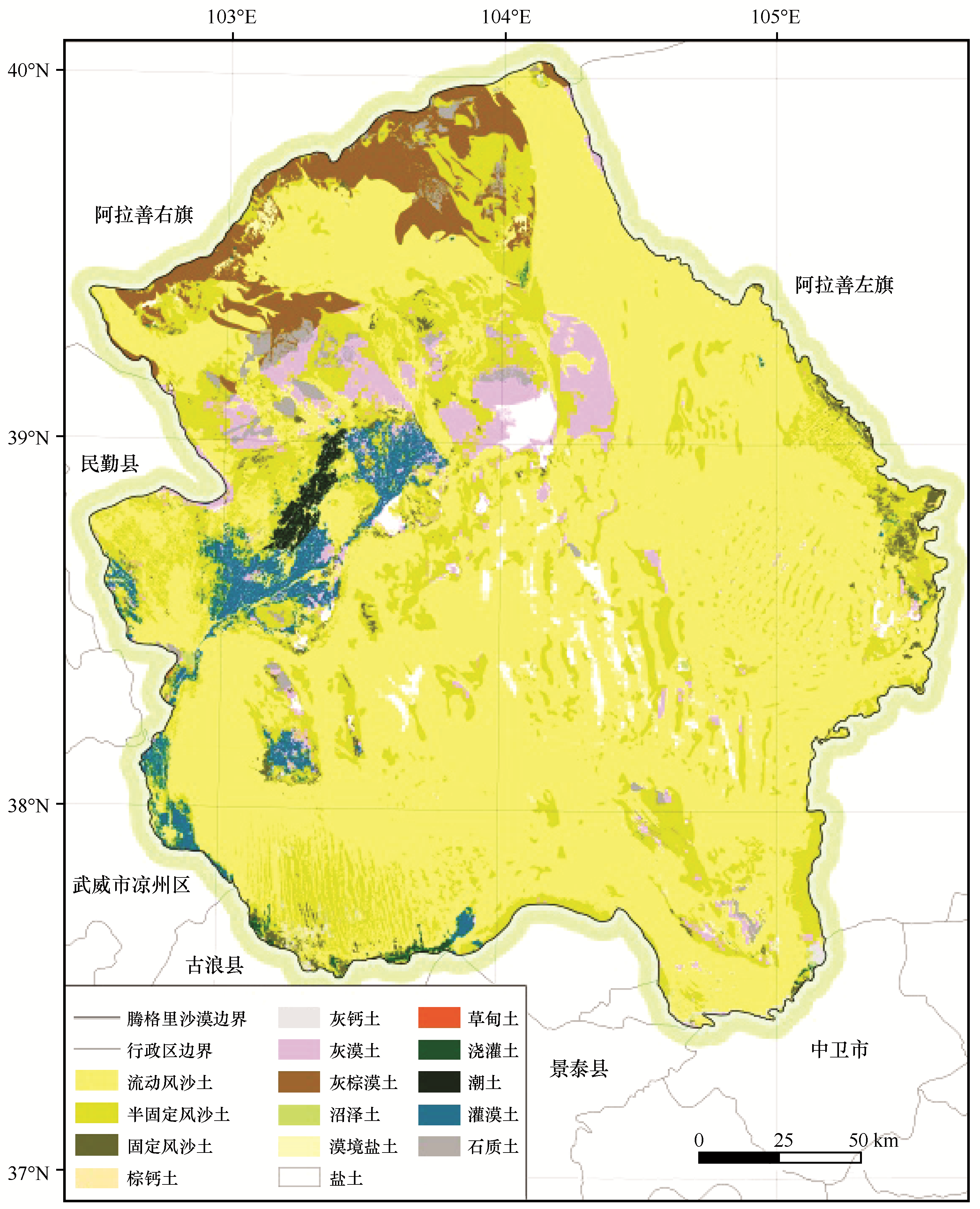
土壤类型空间分布是利用、改良和保护土壤资源的科学依据。腾格里沙漠是中国第四大沙漠,然而对其土壤类型空间分布特征还没有系统的研究。本研究基于中国土壤、内蒙古土壤、甘肃土壤和宁夏土壤等普查成果,以及中国科学院沙坡头沙漠研究试验站综合科学考察的历史资料,在2017—2019年对腾格里沙漠土壤类型及分布进行了大规模考察验证。同时利用遥感(RS)与地理信息系统(GIS)技术,对腾格里沙漠土壤类型进行判读,完成腾格里沙漠土壤类型及分布图制作。腾格里沙漠土壤分类系统共有13个土类,30个亚类,分别归属于7个土纲和10个亚纲。在土壤分布特征方面,腾格里沙漠以非地带性风沙土为主,约占腾格里沙漠面积的83.65%。地带性土壤类型有棕钙土、灰钙土、灰漠土和灰棕漠土,总面积为4 803.20 km2,占腾格里沙漠面积9.42%。其他非地带性土壤有草甸土、沼泽土、盐土、漠境盐土、灌淤土、灌漠土、潮土和石质土,总面积为3 534.83 km2,占腾格里沙漠面积的6.93%。土壤分布存在多种地带与非地带性土壤类型中微域组合。

关键词: 腾格里沙漠, 土壤分类系统, 土壤分布图

Abstract:

Soil types and spatial distribution are the scientific basis for the utilization, improvement and protection of soil resources. The Tengger desert is the fourth largest desert in China, however, the soil types and spatial distribution have not been systematically studied. Based on the national soil, Inner Mongolia soil, Gansu soil and Ningxia soil census results, as well as the comprehensive scientific investigation of Shapotou Desert Research and Experiment Station of Chinese Academy of Sciences, the present study conducted a large-scale investigation and verification on the soil types and distribution of Tengger Desert from 2017 to 2019. Remote sensing (RS) and geographic information system (GIS) were used to detect the soil types of Tengger Desert using the human-machine interactive interpretation method, and the soil classification system and distribution map were completed. There are 13 great group and 30 subgroup in Tengger desert, which belong to 7 order and 10 suborder respectively. Aeolian sandy soil is the most important soil type in Tengger Desert, accounting for 83.65% of the total area of Tengger Desert. The zonal soil are brown pedocals, sierozems, gray desert soil and gray-brown desert soil, with a total area of 4 803.20 km2, accounting for 9.42% of the Tengger desert area. Other non-zonal soils include meadow soil, bog soils, solonchaks, desert solonchaks, irrigated desert soils, fluvo-aquic soils, cumulated irrigated soils, and litho soils, with a total area of 3 534.83 km2, accounting for 6.93% of the Tengger desert area. There are many kinds of micro domain combinations in soil distribution. This study is the basis of land use and planning in the future.

Key words: Tengger Desert, soil classification system, soil distribution map

中图分类号: