
- CN 62-1070/P
- ISSN 1000-694X
- Bimonthly 1981
Journal of Desert Research ›› 2023, Vol. 43 ›› Issue (3): 305-317.DOI: 10.7522/j.issn.1000-694X.2023.00062
Wenfeng Chi1( ), Yuetian Wang1, Xiaohong Dang2, Xiaoguang Wu3,4, Qiancheng Luo1()
Received:2023-03-12
Revised:2023-05-11
Online:2023-05-20
Published:2023-05-31
Contact:
Qiancheng Luo
CLC Number:
Wenfeng Chi, Yuetian Wang, Xiaohong Dang, Xiaoguang Wu, Qiancheng Luo. Temporal variation and spatial pattern of soil erosion in the Yellow River Basin[J]. Journal of Desert Research, 2023, 43(3): 305-317.
Add to citation manager EndNote|Ris|BibTeX
URL: http://www.desert.ac.cn/EN/10.7522/j.issn.1000-694X.2023.00062
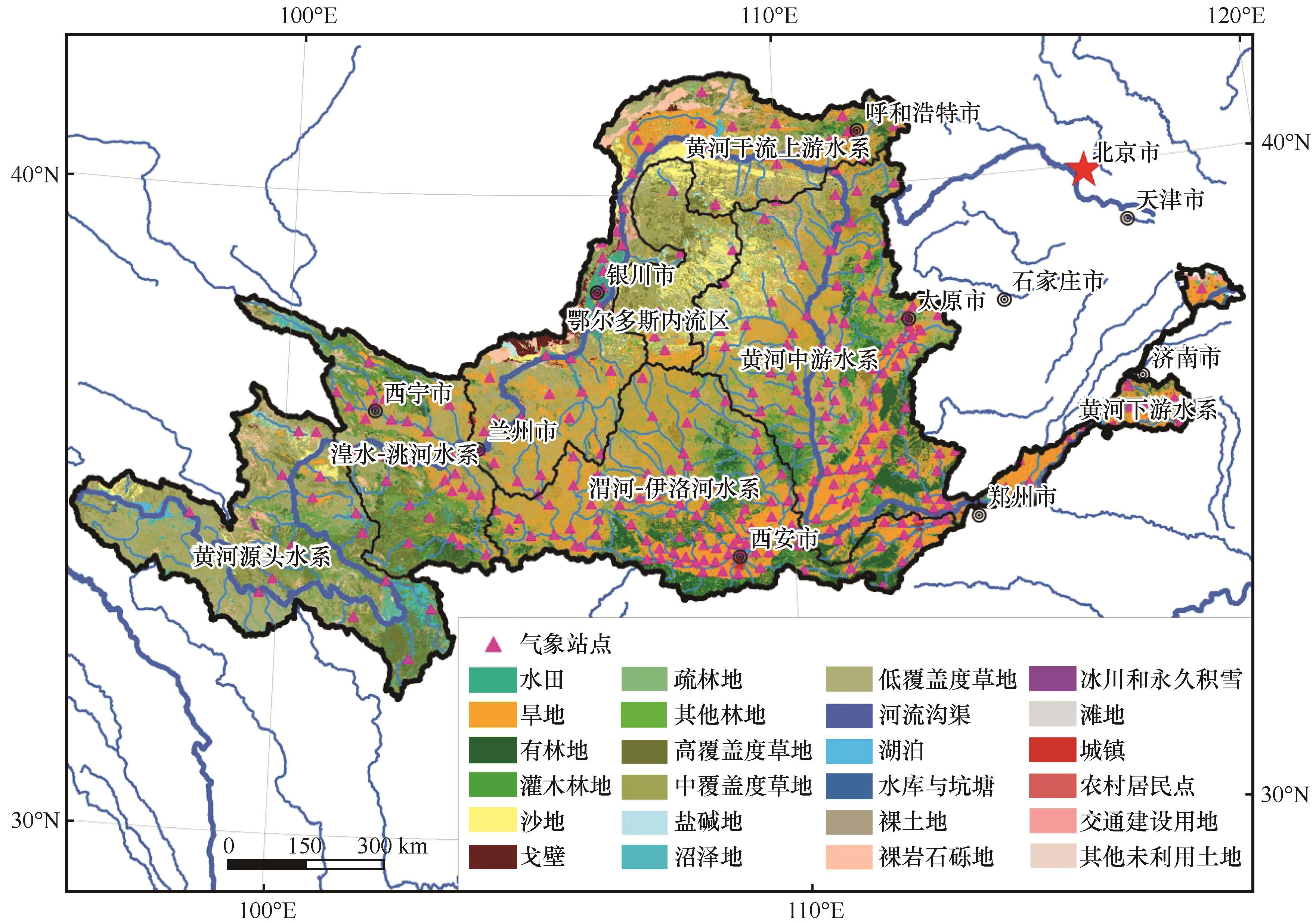
Fig.1 The land use/cover structure and watershed area of 2020 in the Yellow River Basin
| 数据类型 | 空间分辨率/比例尺 | 时间分辨率 | 格式 |
|---|---|---|---|
| 遥感影像 | 2~15 m | 年 | Raster |
| 土地利用/覆盖数据 | 1∶10万 | 年 | shpfile |
| 气象数据 | 监测站点(311个) | 日 | Txt |
| 植被覆盖度(NDVI)数据 | 250 m | 8 d | Raster |
| 土壤类型(含养分)数据 | 1∶100万 | N/A | shpfile |
| 雪覆盖数据 | 1 km | 16 d | Raster |
| 植被覆盖度样方数据 | 样点 | 2010、2015、2020年 | shpfile |
| 土壤表层/剖面样点数据 | 样点 | 2010、2015、2020年 | shpfile |
| 数字高程(DEM)数据 | 30 m | N/A | Raster |
| 基础地理数据 | 1∶25万 | N/A | shpfile |
| 地貌类型数据 | 1∶25万 | N/A | shpfile |
Table 1 Data sources and paranmeters
| 数据类型 | 空间分辨率/比例尺 | 时间分辨率 | 格式 |
|---|---|---|---|
| 遥感影像 | 2~15 m | 年 | Raster |
| 土地利用/覆盖数据 | 1∶10万 | 年 | shpfile |
| 气象数据 | 监测站点(311个) | 日 | Txt |
| 植被覆盖度(NDVI)数据 | 250 m | 8 d | Raster |
| 土壤类型(含养分)数据 | 1∶100万 | N/A | shpfile |
| 雪覆盖数据 | 1 km | 16 d | Raster |
| 植被覆盖度样方数据 | 样点 | 2010、2015、2020年 | shpfile |
| 土壤表层/剖面样点数据 | 样点 | 2010、2015、2020年 | shpfile |
| 数字高程(DEM)数据 | 30 m | N/A | Raster |
| 基础地理数据 | 1∶25万 | N/A | shpfile |
| 地貌类型数据 | 1∶25万 | N/A | shpfile |
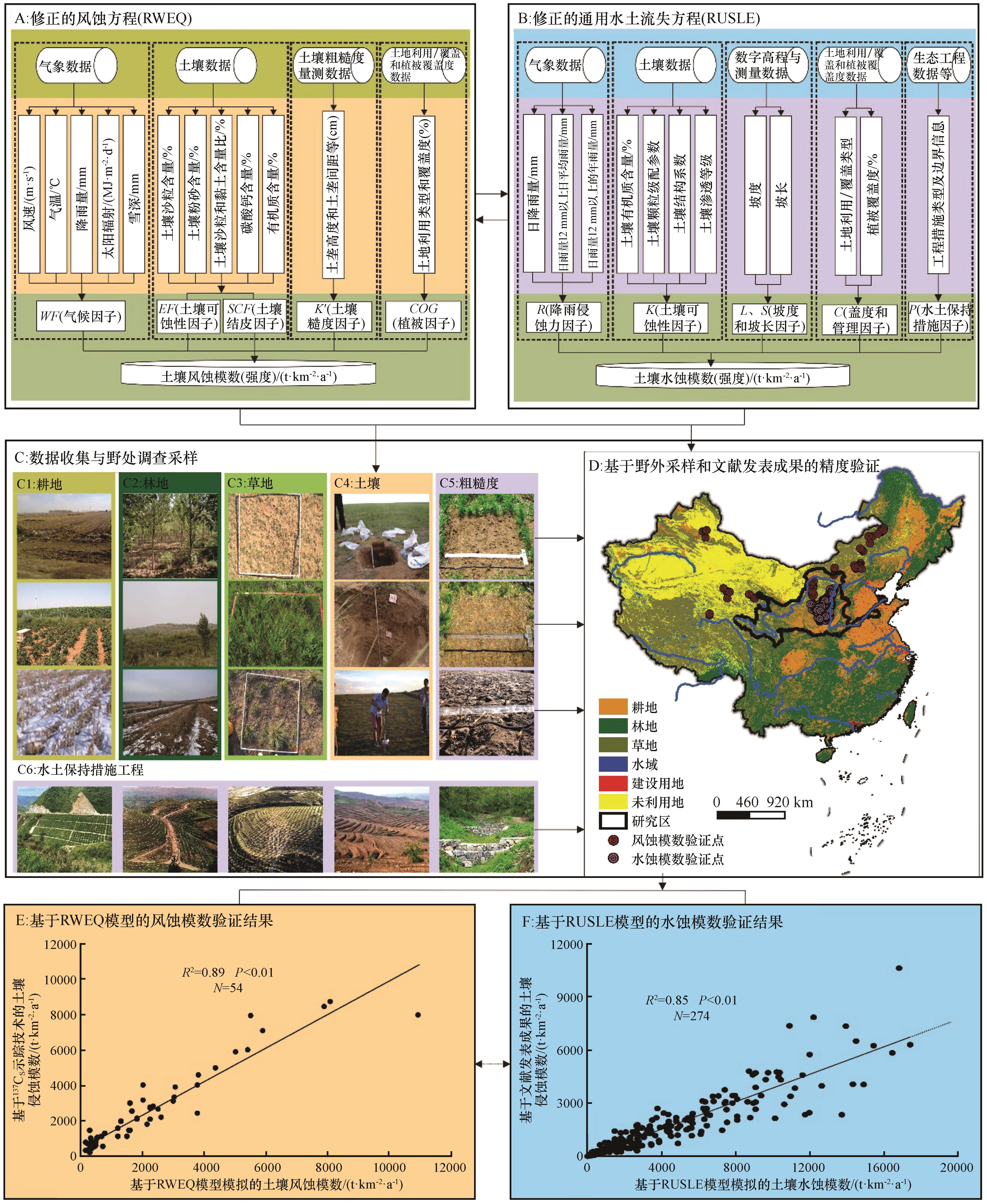
Fig.2 The technical flowchart of this study[2,14,19]
| 分级 | 平均侵蚀模数/(t·km-2·a-1) | 土壤风蚀与水蚀主导区判断规则 |
|---|---|---|
| 1 微度侵蚀 | <200 | 土壤风蚀和水蚀模数< 200 t·km-2·a-1 叠加,风、水蚀均可 |
| 2轻度侵蚀 | 200~2 500 | 土壤风蚀和水蚀模数200~2 500 t·km-2·a-1 叠加,大者赋主导类型(例如;风蚀模 数≥水蚀模数,赋值为风蚀轻度侵蚀区;否则反之,以下分级分类标准一致) |
| 3 中度侵蚀 | 2 500~5 000 | 土壤风蚀和水蚀模数2 500~5 000 t·km-2·a-1 叠加,值大者赋主导类型 |
| 4 强烈侵蚀 | 5 000~8 000 | 土壤风蚀和水蚀模数5 000~8 000 t·km-2·a-1 叠加,值大者赋主导类型 |
| 5 极强烈侵蚀 | 8 000~15 000 | 土壤风蚀和水蚀模数8 000~15 000 t·km-2·a-1 叠加,值大者赋主导类型 |
| 6 剧烈侵蚀 | ≥15 000 | 土壤风蚀和水蚀模数≥15 000 t·km-2·a-1 叠加,值大者赋主导类型 |
Table 2 Classification criterion of soil erosion[39]
| 分级 | 平均侵蚀模数/(t·km-2·a-1) | 土壤风蚀与水蚀主导区判断规则 |
|---|---|---|
| 1 微度侵蚀 | <200 | 土壤风蚀和水蚀模数< 200 t·km-2·a-1 叠加,风、水蚀均可 |
| 2轻度侵蚀 | 200~2 500 | 土壤风蚀和水蚀模数200~2 500 t·km-2·a-1 叠加,大者赋主导类型(例如;风蚀模 数≥水蚀模数,赋值为风蚀轻度侵蚀区;否则反之,以下分级分类标准一致) |
| 3 中度侵蚀 | 2 500~5 000 | 土壤风蚀和水蚀模数2 500~5 000 t·km-2·a-1 叠加,值大者赋主导类型 |
| 4 强烈侵蚀 | 5 000~8 000 | 土壤风蚀和水蚀模数5 000~8 000 t·km-2·a-1 叠加,值大者赋主导类型 |
| 5 极强烈侵蚀 | 8 000~15 000 | 土壤风蚀和水蚀模数8 000~15 000 t·km-2·a-1 叠加,值大者赋主导类型 |
| 6 剧烈侵蚀 | ≥15 000 | 土壤风蚀和水蚀模数≥15 000 t·km-2·a-1 叠加,值大者赋主导类型 |
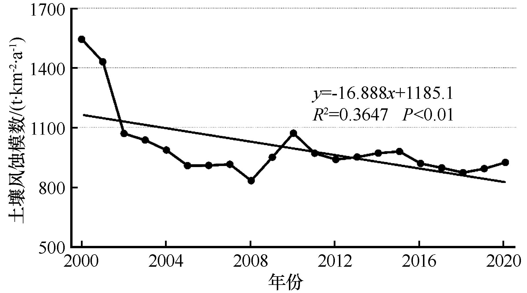
Fig.3 The change of soil wind erosion modulus in the Yellow River Basin from 2000 to 2020
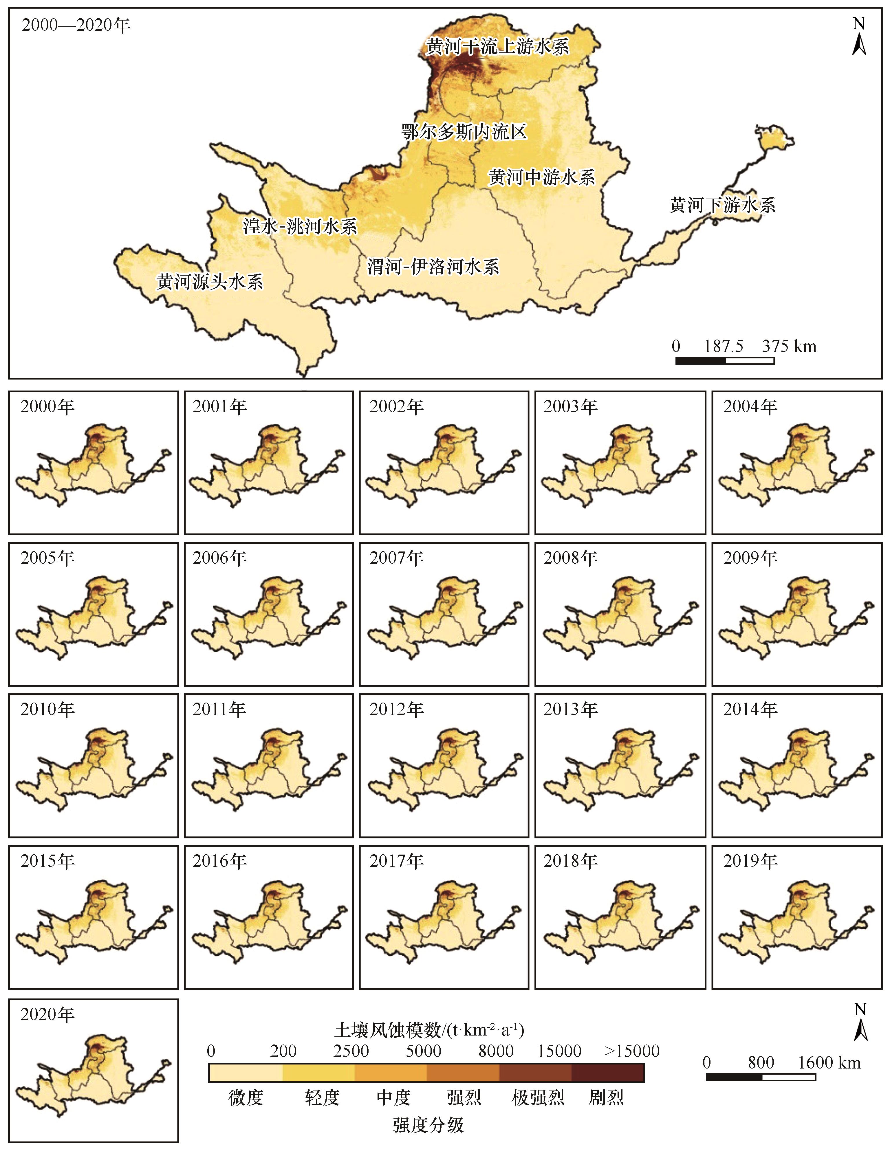
Fig.4 Spatial distribution pattern of soil wind erosion in the Yellow River Basin from 2000 to 2020
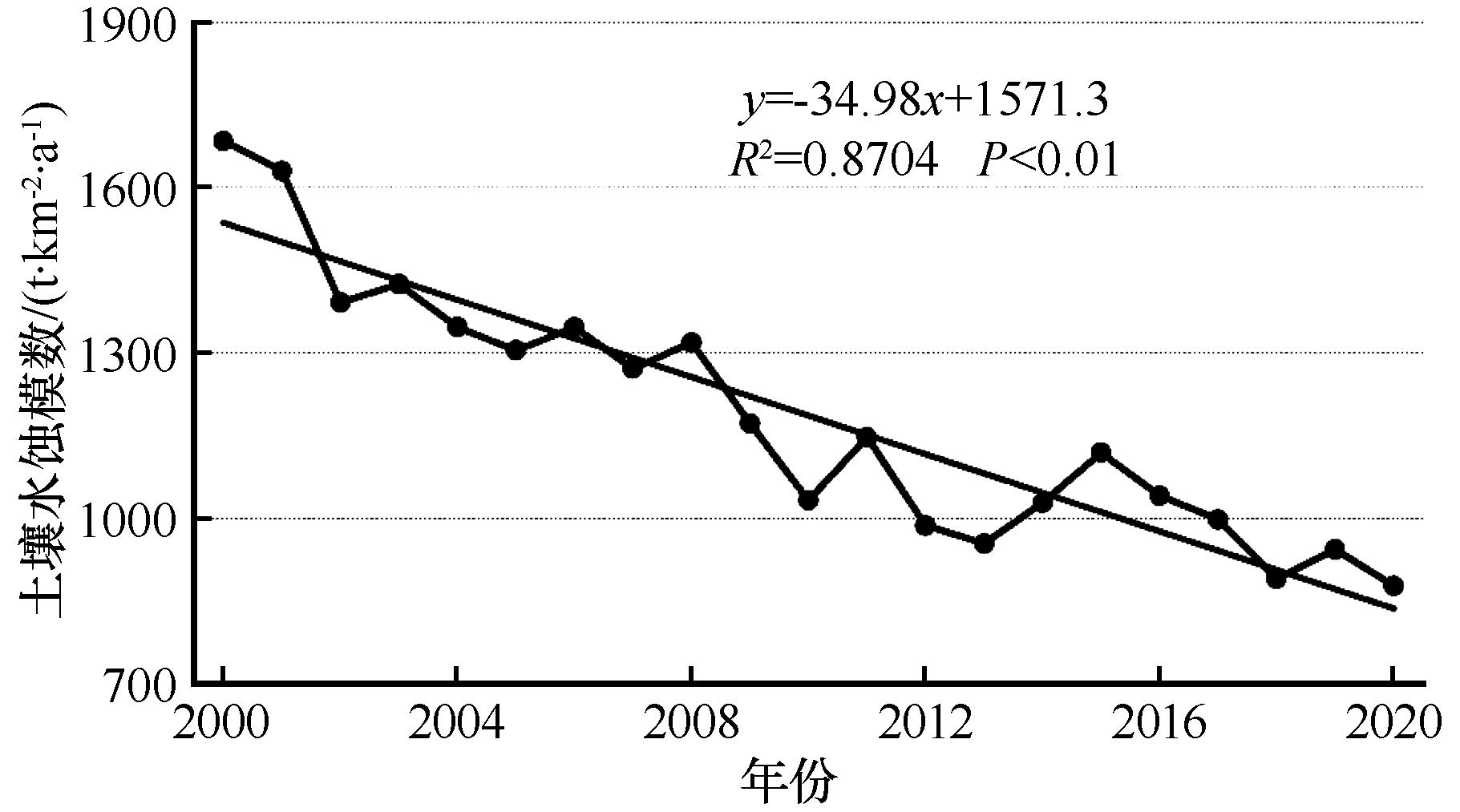
Fig.5 The change of soil water erosion modulus in the Yellow River Basin from 2000 to 2020
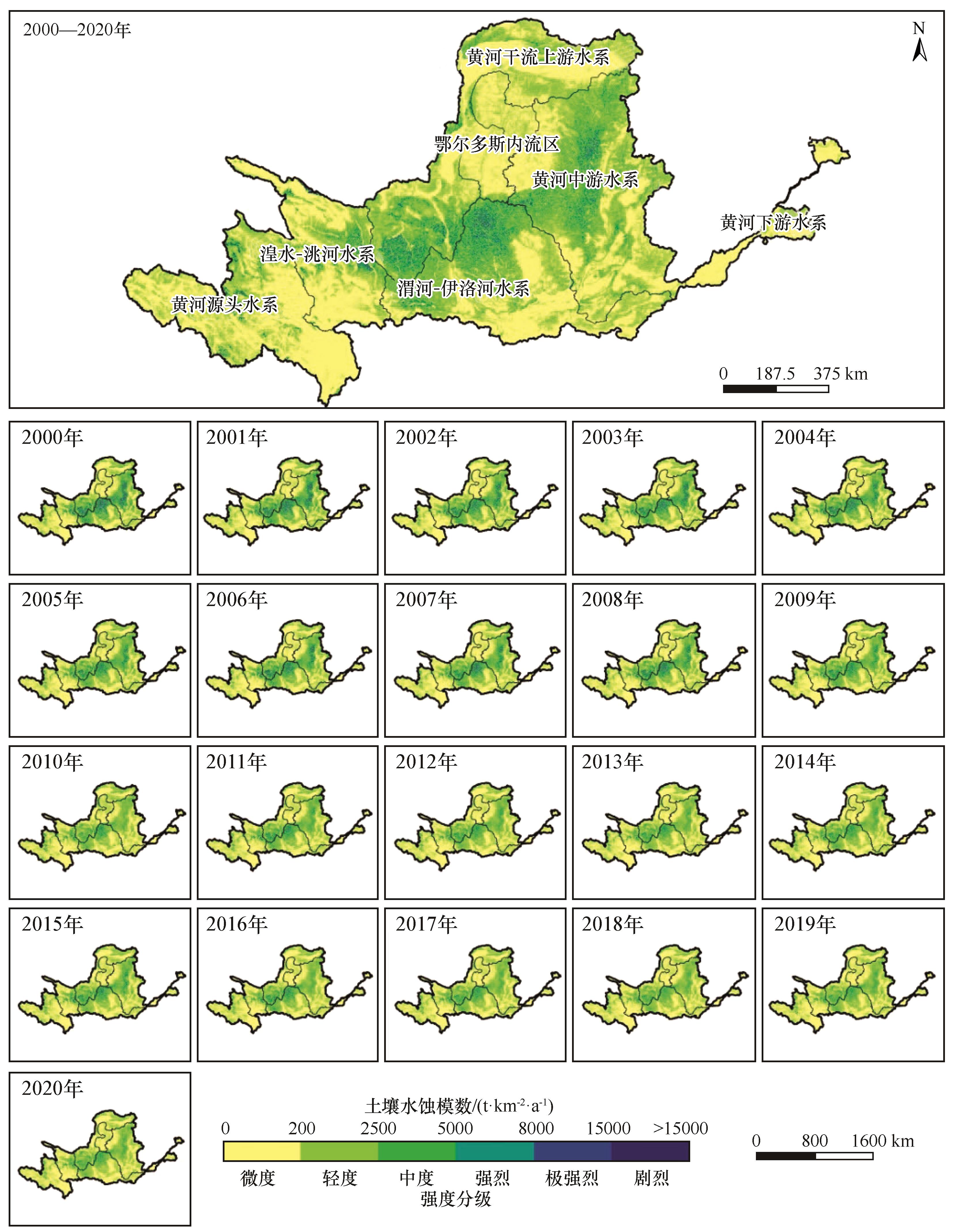
Fig.6 Spatial distribution pattern of soil water erosion in the Yellow River Basin from 2000 to 2020
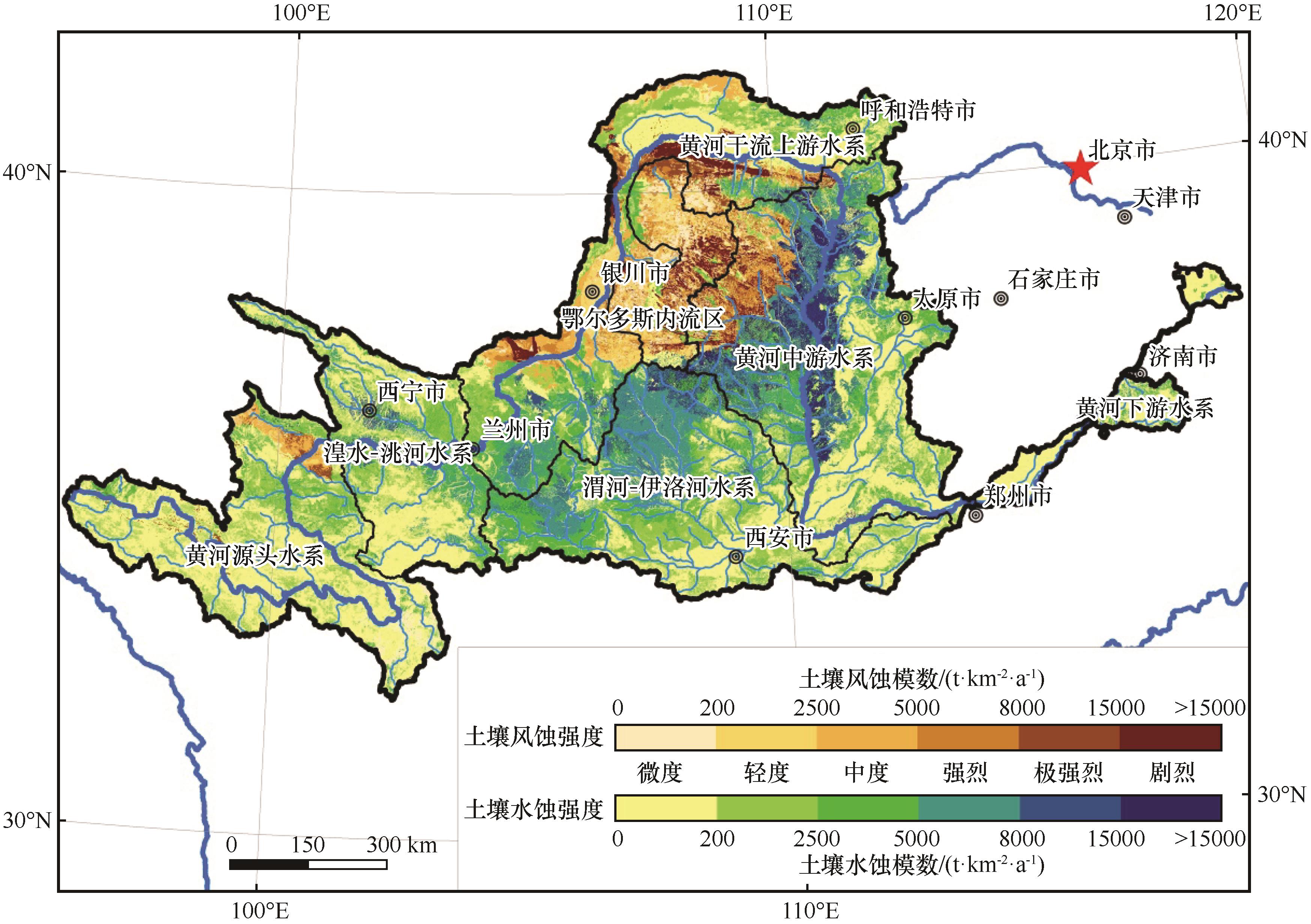
Fig.7 Characteristics of dominant types and intensity pattern of soil wind and water erosion in the Yellow River Basin
| 侵蚀类型 分区 | 侵蚀 强度 | 鄂尔多斯 内流区 | 黄河干流 上游水系 | 黄河源头 水系 | 湟水-洮河 水系 | 黄河下游 水系 | 黄河中游 水系 | 渭河-伊洛河水系 |
|---|---|---|---|---|---|---|---|---|
| 土壤风蚀 | 微度 | 8 887.45 | 7 886.54 | 5 936.91 | 0.20 | 80.33 | 2 681.95 | 0.00 |
| 轻度 | 7 914.29 | 13 674.17 | 731.95 | 0.00 | 0.00 | 3 696.64 | 5.67 | |
| 中度 | 7 774.61 | 16 142.45 | 4 049.34 | 0.00 | 0.00 | 4 935.66 | 0.15 | |
| 强烈 | 4 467.64 | 7 006.11 | 114.08 | 4.08 | 0.00 | 6 620.02 | 0.00 | |
| 极强烈 | 3 916.47 | 3 910.87 | 3 215.53 | 42.54 | 0.00 | 3 060.93 | 0.00 | |
| 剧烈 | 5 064.67 | 6 654.55 | 40.82 | 0.00 | 0.00 | 45 94.53 | 0.00 | |
| 土壤水蚀 | 微度 | 3 273.58 | 43 589.34 | 90 601.16 | 50 252.26 | 22 497.93 | 67 883.22 | 57 601.50 |
| 轻度 | 1 172.81 | 24 995.75 | 25 000.09 | 17 936.13 | 715.75 | 20 749.71 | 27 131.17 | |
| 中度 | 1 777.32 | 20 317.38 | 10 531.54 | 12 591.47 | 2 532.20 | 25 982.12 | 28 285.32 | |
| 强烈 | 394.92 | 14 102.67 | 310.35 | 7 420.71 | 779.23 | 24 913.39 | 33 480.99 | |
| 极强烈 | 56.37 | 2 423.80 | 67.01 | 2 451.98 | 81.65 | 13 704.85 | 4 807.01 | |
| 剧烈 | 191.81 | 81.83 | 138.38 | 271.73 | 12.72 | 17 263.30 | 2 576.10 |
Table 3 Areas of wind-dominated and water-dominated erosion region classified into different erosion intensity in the secondary basins of the Yellow River Basin(km2)
| 侵蚀类型 分区 | 侵蚀 强度 | 鄂尔多斯 内流区 | 黄河干流 上游水系 | 黄河源头 水系 | 湟水-洮河 水系 | 黄河下游 水系 | 黄河中游 水系 | 渭河-伊洛河水系 |
|---|---|---|---|---|---|---|---|---|
| 土壤风蚀 | 微度 | 8 887.45 | 7 886.54 | 5 936.91 | 0.20 | 80.33 | 2 681.95 | 0.00 |
| 轻度 | 7 914.29 | 13 674.17 | 731.95 | 0.00 | 0.00 | 3 696.64 | 5.67 | |
| 中度 | 7 774.61 | 16 142.45 | 4 049.34 | 0.00 | 0.00 | 4 935.66 | 0.15 | |
| 强烈 | 4 467.64 | 7 006.11 | 114.08 | 4.08 | 0.00 | 6 620.02 | 0.00 | |
| 极强烈 | 3 916.47 | 3 910.87 | 3 215.53 | 42.54 | 0.00 | 3 060.93 | 0.00 | |
| 剧烈 | 5 064.67 | 6 654.55 | 40.82 | 0.00 | 0.00 | 45 94.53 | 0.00 | |
| 土壤水蚀 | 微度 | 3 273.58 | 43 589.34 | 90 601.16 | 50 252.26 | 22 497.93 | 67 883.22 | 57 601.50 |
| 轻度 | 1 172.81 | 24 995.75 | 25 000.09 | 17 936.13 | 715.75 | 20 749.71 | 27 131.17 | |
| 中度 | 1 777.32 | 20 317.38 | 10 531.54 | 12 591.47 | 2 532.20 | 25 982.12 | 28 285.32 | |
| 强烈 | 394.92 | 14 102.67 | 310.35 | 7 420.71 | 779.23 | 24 913.39 | 33 480.99 | |
| 极强烈 | 56.37 | 2 423.80 | 67.01 | 2 451.98 | 81.65 | 13 704.85 | 4 807.01 | |
| 剧烈 | 191.81 | 81.83 | 138.38 | 271.73 | 12.72 | 17 263.30 | 2 576.10 |
| 1 | Borrelli P, Robinson D A, Fleischer L R,et al.An assessment of the global impact of 21st century land use change on soil erosion[J].Nature Communications,2017,8(1):2013. |
| 2 | Chi W F, Zhao Y Y, Kuang W H,et al.Impact of cropland evolution on soil wind erosion in Inner Mongolia of China[J].Land,2021,10(6):583. |
| 3 | Li C J, Fu B J, Wang S,et al.Drivers and impacts of changes in China's drylands[J].Nature Reviews Earth and Environment,2021,2(12):858-873. |
| 4 | Rolf N, Benbi D, Reichl F X,et al.Soil-borne gases and their influence on environment and human health[M]//Soil Components and Human Health.Berlin,Germany:Springer,2018:179-221. |
| 5 | Lal R.Accelerated soil erosion as a source of atmospheric CO2 [J].Soil & Tillage Research,2019,188:35-40. |
| 6 | 杨会民,王静爱,邹学勇,等.风水复合侵蚀研究进展与展望[J].中国沙漠,2016,36(4):962-971. |
| 7 | Remus Pravalie.Drylands extent and environmental issues:a global approach[J].Earth Science Reviews,2016,161:259-278. |
| 8 | Gao L, Bryan B A.Finding pathways to national-scale land-sector sustainability[J]. Nature,2017,544(7649):217-222. |
| 9 | Jules P, Benton T G, Pervez B Z,et al.Global assessment of agricultural system redesign for sustainable intensification[J].Nature Sustainability,2018,1(8):441-446. |
| 10 | Nagendra H, Bai X, Brondizio E S,et al.The urban south and the predicament of global sustainability[J].Nature Sustainability,2018,1(7):341-349. |
| 11 | 程清平,钟方雷,左小安,等.美丽中国与联合国可持续发展目标(SDGs)结合的黑河流域水资源承载力评价[J].中国沙漠,2020,40(1):204-214. |
| 12 | 高卿,骆华松,王振波,等.美丽中国的研究进展及展望[J].地理科学进展,2019,38(7):1021-1033. |
| 13 | 刘珺,郭中领,常春平,等.基于RWEQ和WEPS模型的中国北方农牧交错带潜在风蚀模拟[J].中国沙漠,2021,41(2):27-37. |
| 14 | Chi W F, Zhao Y Y, Kuang W H,et al.Impacts of anthropogenic land use/cover changes on soil wind erosion in China[J].Science of the Total Environment,2019,668:204-215. |
| 15 | Skidmore E L, Tatarko J.Stochastic wind simulation for erosion modeling[J].Transactions of the ASABE,1990,33(6):1893-1899. |
| 16 | Bilbro J D, Fryrear D W.Wind erosion losses as related to plant silhouette and soil cover[J].Agronomy Journal,1994,86(3):550-553. |
| 17 | 李宏薇,许尔琪,张红旗.伊犁河谷土壤侵蚀综合分区[J].中国农业资源与区划,2018,39(4):116-124. |
| 18 | Clinton N, Yu L, Gong P.Geographic stacking:Decision fusion to increase global land cover map accuracy[J].ISPRS Journal of Photogrammetry & Remote Sensing,2015,103(5):57-65. |
| 19 | Liu W C, Liu J, Kuang W H.Spatiotemporal patterns of soil protection effect of the Grain for Green Project in northern Shaanxi[J].Acta Geographica Sinica,2019,74(9):1835-1852. |
| 20 | 安志山,李栋梁,王涛,等.气候变化对风水蚀复合区的影响[J].中国沙漠,2012,32(3):610-617. |
| 21 | 傅伯杰.生态系统服务与生态安全[M].北京:高等教育出版社,2013. |
| 22 | Liu Y H, Yang Z L, Lin P,et al.Comparison and evaluation of multiple land surface products for the water budget in the Yellow River Basin[J].Journal of Hydrology,2019,584:124534. |
| 23 | 郑景云,文彦君,方修琦.过去2000年黄河中下游气候与土地覆被变化的若干特征[J].资源科学,2020,42(1):3-19. |
| 24 | 高海东,李占斌,李鹏,等.基于土壤侵蚀控制度的黄土高原水土流失治理潜力研究[J].地理学报,2015,70(9):1503-1515. |
| 25 | 王坤平,黄建胜,赵院.黄河流域生态工程重点小流域治理经验与做法[J].中国水土保持,2002(10):16-17. |
| 26 | 傅伯杰,赵文武,陈利顶,等.多尺度土壤侵蚀评价指数[J].科学通报,2006,51(16):1936-1943. |
| 27 | 刘纪远,匡文慧,张增祥,等.20世纪80年代末以来中国土地利用变化的基本特征与空间格局[J].地理学报,2014,69(1):3-14. |
| 28 | Feng X M, Fu B J, Piao S L,et al.Revegetation in China's Loess Plateau is approaching sustainable water resource limits[J].Nature Climate Change,2016,6:1019-1022. |
| 29 | 孙会慧,石培基,颜丙金,等.黄河上游生态脆弱区土地利用规模和结构调整的环境影响评价研究:以兰州市为例[J].水土保持通报,2013,33(5):245-249. |
| 30 | Fu B J, Wang S, Liu Y,et al.Hydrogeomorphic ecosystem responses to natural and anthropogenic changes in the Loess Plateau of China[J].Annual Review of Earth and Planetary Sciences,2017,45(1):223-243. |
| 31 | 邓鑫欣,张加琼,杨明义,等.黄土高原水蚀风蚀交错带坡耕地土壤风蚀特征[J].水土保持研究,2019,26(3):1-6. |
| 32 | 邓鑫欣,张加琼,杨明义,等.黄土高原水蚀风蚀交错带坡耕地土壤风蚀速率空间分布[J].科学通报,2016,61():511-517. |
| 33 | 李永平,杨改河,冯永忠,等.黄土高原土壤风蚀区玉米起垄覆盖集水效应[J].农业工程学报,2009,25(4):59-65. |
| 34 | Zhang S T, Jia Y G, Fang L,et al.Effects of upward seepage on the resuspension of consolidated silty sediments in the Yellow River Delta[J].Journal of Coastal Research,2020,36(2):643-670. |
| 35 | Bryan B A, Gao L, Ye Y,et al.China's response to a national land-system sustainability emergency[J].Nature,2018,559(7713):193-204. |
| 36 | 周丹,张勃,安美玲,等.黄河流域不同时间尺度干旱对ENSO事件的响应[J].中国沙漠,2015,35(3):753-762. |
| 37 | 王俊杰,拾兵,柏涛,等.黄河流域降水格局及影响因素[J].中国沙漠,2022,42(6):94-102. |
| 38 | Huang S Z, Huang Q, Chang J X,et al.Drought structure based on a nonparametric multivariate standardized drought index across the Yellow River basin,China[J].Journal of Hydrology,2015,530:127-136. |
| 39 | 中华人民共和国水利部.土壤侵蚀分类分级标准:SL190-2007[M].北京:中国水利水电出版社,2008. |
| 40 | 迟文峰,白文科,刘正佳,等.基于RWEQ模型的内蒙古高原土壤风蚀研究[J].生态环境学报,2018,27(6):1024-1033. |
| 41 | Zhao Y Y, Chi W F, Kuang W H,et al.Ecological and environmental consequences of ecological projects in the Beijing-Tianjin sand source region[J].Ecological Indicators,2020,112(5):106111. |
| 42 | Fryrear D W, Krammes C A, Williamson D L,et al.Computing the wind erodible fraction of soils[J].Journal of Soil and Water Conservation,1994,49:183-188. |
| 43 | 刘广峰,吴波,范文义,等.基于像元二分模型的沙漠化地区植被覆盖度提取:以毛乌素沙地为例[J].水土保持研究,2007,14(2):268-271. |
| 44 | Oro L A D, Colazo J C, Buschiazzo D E.RWEQ-wind erosion predictions for variable soil roughness conditions[J].Aeolian Research,2016,20:139-146. |
| 45 | 王仁德,安晨宇,苑依笑,等.不同时间尺度下农田土壤风蚀可蚀性的变化[J].中国沙漠,2021,41(5):202-209. |
| 46 | 章文波,谢云,刘宝元.利用日雨量计算降雨侵蚀力的方法研究[J].地理科学,2002(6):705-711. |
| 47 | Renard K G, Foster G R, Weesises G A,et al.Predicting soil erosion by water:a guide to conservation planning with the Revised Universal Soil Loss equation (RUSLE) [R]//USDA Agriculture Handbook No.703.Washington DC,USA:US Department of Agriculture,1997:1-367. |
| 48 | McCool D K, Foster G R, Mutchler C K.et al.Revised slope length factor for the universal soil loss equation[J].Transactions of the ASAE,1989,32(5):1571-1576. |
| 49 | 刘宝元,张科利.土壤可蚀性及其在侵蚀预报中的应用[J].自然资源学报,1999,14(4):345-350. |
| 50 | 蔡崇法,丁树文,史志华,等.应用USLE模型与地理信息系统IDRISI预测小流域土壤侵蚀量的研究[J].水土保持学报,2000,14(2):19-24. |
| 51 | Wang F, Pan X B, Gerlein-Safdi C,et al.Vegetation restoration in Northern China:a contrasted picture[J].Land Degradation & Development,2020,31(6):669-676. |
| 52 | 雷燕慧,丁国栋,李梓萌,等.京津风沙源治理工程区土地利用/覆盖变化及生态系统服务价值响应[J].中国沙漠,2021,41(6):29-40. |
| 53 | Lv Y H, Fu B J, Feng X M,et al.A policy-driven large scale ecological restoration:quantifying ecosystem services changes in the Loess Plateau of China[J].PLoS One,2012,7(2):e31782. |
| 54 | Chen C, Park T, Wang X H,et al.China and India lead in greening of the world through land-use management[J].Nature Sustainability,2019,2:122-129. |
| 55 | 傅伯杰,陈利顶,马克明.黄土丘陵区小流域土地利用变化对生态环境的影响:以延安市羊圈沟流域为例[J].地理学报,1999,54(3):241-246. |
| 56 | Chi W F, Wang Y T, Lou Y X,et al.Effect of land use/cover change on soil wind erosion in the Yellow River Basin since the 1990s[J].Sustainability,2022,14(19):12930. |
| 57 | Wu Z T, Wu J J, Liu J H,et al.Increasing terrestrial vegetation activity of ecological restoration program in the Beijing-Tianjin Sand Source Region of China[J].Ecological Engineering,2013,52:37-50. |
| 58 | Zhao Y Y, Wu J G, He C Y,et al.Linking wind erosion to ecosystem services in drylands:a landscape ecological approach[J].Landscape Ecology,2017,32(12):2399-2417. |
| Viewed | ||||||
|
Full text |
|
|||||
|
Abstract |
|
|||||
©2018Journal of Desert Research
Tel:0931-8267545
Email:caiedit@lzb.ac.cn;desert@lzb.ac.cn
Support:Magtech